Tag Archives: Squamish

Brew Hut 04/06/10

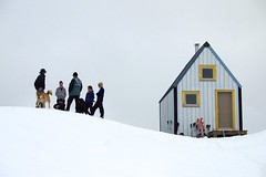
Robert D. at Brew Hut:
“The somewhat unusual timing of a snow shoe trip (Friday evening to Saturday afternoon) proved too good an opportunity for 10 of us to miss. So Paige, Jennifer, Mazy, Robert, Iain, Allan, Mike, Rebeka, Scott and Andrew drove to the trail head on the Roe Creek FSR to follow the winter route. Headlamps and rain gear were used almost from the outset and snow was underfoot pretty quickly too. The trail was surprisingly easy to follow at night in the forested section, the reflective markers easily visible with our headlamps. Once we got up to the alpine, however, a GPS was used (and well needed!) to find the hut. Despite there being plenty of snow underfoot the weather was surprisingly warm. We arrived at the hut about 2 am. Many thanks to those who provided some well-deserved night caps!

Saturday morning was spent exploring around the hut. Most of us hiked back to the cars in as little as 2 hours. The hut itself is small but bright and well built. All in all it was a pleasure to stay there. Always best to check the availability first on
https://www.ubc-voc.com/wiki/VOC_Hut_Registration.”

Brew Mountain

High Falls Creek, 15 May 2010

Su-Laine at High Falls Creek:
“Eight of us enjoyed a mostly-sunny day hiking and scrambling up the steep and varied trail to the High Falls Creek viewpoint, and walking along the gentle logging road back down. The trail was in great shape with no snow and no difficulties with creek crossings. Note that the driving directions in ‘103 Hikes’ 5th edition are less than ideal.”

Sigurd Peak 04/05/10

Erez on Sigurd Peak:
“A bunch of us woke up early and left Vancouver at 6 am for Sigurd Peak near Squamish. We started hiking at 8:30 and the weather was great (blue skies with almost all the peaks around us visible) albeit a pessimistic forecast. The trail is very steep and well-marked until the junction with the trail heading for the creek. Afterwards, the trail markers begin to thin out, and we made our own way towards the ridge. There is quite a lot of fallen trees on the trail especially after the junction. Snow started at 750 m. The snow was quite soft and snowshoes were needed. Two of us also used crampons. We reached the lesser peak (1600 m), from which it is another 300 m climb to the actual peak, at around 14:30 and decided to call it a day after seeing some ominous clouds heading towards us, and being satisfied with the gorgeous view we already see. We made it back to the car at 20:30. On the way back driving the logging road we saw a small black bear. I was in the area last Thursday and saw another (or the same one?) on the trail itself. All in all, it was a great trip with great company.”

DSC02366

Cloudburst 02/05/10

Ahmad on Cloudburst Mountain:
“Doing the same trail exactly on the same day one year before, this I found it less demanding physically but mentally tougher. We parked further up by 2 km than last time which saved good 4 km of logging road hiking which I wasn’t looking forward to do. However, the weather was worse. Once we were on the peak, visibility reduced to zero where I couldn’t see where I was stepping next. It was accompanied by wind and blizzard. Our track to the top was wiped out quickly. We waited for any opportunity of clearing to bypass the cliff section. After a while, our hope for the weather to calm down faded. We decided to negotiate the peak ridge slowly with GPS mainly backed by compass and map as verification. It was quite sketchy.

Snow condition wasn’t bad. There was more snow on the top this time than last year but less at the bottom. we had the entire mountain to ourselves. Pictures and our GPS track are on Live Trails.”

Elfin Lakes 03/04/10

Malin at Elfin Lakes:
“The weekend started out with a blizzard, but ended with beautiful sunshine, warm temperatures and magnificent views. Danette, Brandon, Dennis and I left Vancouver early on Saturday morning and headed towards Squamish. The logging road up to the trailhead was in much better condition than three weeks earlier and no chains were needed. There was however lots of snow on the trail. Around lunchtime the sun teased us by letting a bit of light through the heavy clouds, but after lunch in Red Heather Hut the snow was coming down quite heavily and the wind picked up. The hike along Paul Ridge offered no views and we were quite happy to reach the Elfin Lakes shelter in the late afternoon. The shelter was half covered in snow and had to be entered through the balcony door. The first task after having reserved a bunk bed was to dig out the outhouse, which was completely covered. The shelter filled slowly, but by the time we finished supper every bunk bed was filled. The next morning the fog and clouds had all unexpectedly blown away and the Gargoyles and surrounding peaks were clearly visible against a blue sky. This area is so full of surprises and every visit is a new experience. Due to the gloomy hike up the previous day, we took our time and appreciated every minute of our trip back.”

Cheakamus Canyon 06/02/10

Michelle in Cheakamus Canyon:
“Green mountains and spandex-clad road cyclists cruising down the Sea to Sky, you know – just your typical winter scenery. The only signs of the impending WINTER Olympics were the Olympic Lane signs starting one block East of Kootenay Loop on Hastings St (FYI – may be a tad trickier than anticipated using this meet spot during the games), sign boards blinking about upcoming road restrictions and the two million metal pole lane dividers hiltied into the asphalt at every single set of curves in the road (basically the whole thing). Traffic was light, but lanes are narrow, and driving wasn’t super speedy. Neither was the hiking – we just ambled along the easy trail happily taking pictures all the while. An enjoyable spring like outing whose only hint of winter was the frosty wind that occasionally blasted through the canyon.”

Elfin Lakes 23/01/10

Chris M. at Elfin Lakes:
“Eight snowshoers and a skier left the parking lot before 6 am! The clouds came in but there was still some interesting alpenglow. Enough soft snow to keep us all happy. We went out over the humps of Pauls Ridge then took the regular trail back. Home to Vancouver by 3 pm after a stop at Galileo Coffee in Britannia Beach.”

Early Elfin Jan 24, 09 030

The Chief 01/11/09

Ahmad on the Chief:
“Almost no people when we started at 10 am. It was the first time I’ve seen the Chief that empty especially on a nice day like today. Not much of a difference than it was one month ago except things seemed wetter and colder. The scramble is easy with ropes and all of us managed without a problem. The last one is difficult but the rope makes it easy. We went up also on the second peak and descended via the main trail. Dogs cannot get over the chained-steep section. We saw few dogs got stuck there. This trail is not obvious. It branches off in several places. It took us 6 hours at a luxury pace.”

Sigurd Creek 27/06/09

Steve following Sigurd Creek:
“I hiked with Ming, Dennis, Chad, and Jessica to the knoll on the Sigurd Creek trail near Squamish. On 2 attempts in previous years I got no further than Crooked Falls in May due to snow. This time, no problem due to snow or windfall. That being said, the trail was a bit buggy, and quite steep. Despite a more open view from the knoll, and more broad look at the huge cascading falls, the Crooked Falls viewpoint at the mid-point remained the highlight. This has to be one of the best falls viewpoints I’ve been to in the Lower Mainland, partially because you can get right next to them. Note that the logging road forces you to check in at a construction station, and the construction site saw fit to sign a short-cut for the trail: ignore it and follow the usual trail descriptions (we used 103 Hikes)”

Crooked Falls

Levette Lake 06/06/09

Su-Laine at Levette Lake:
“Lots of changes to this trail since the 5th edition of 109 Walks came out in 2002! Forget about trying to count how many private roads emerge on the left on the way to the lake, and just look for the trail entrance (which no longer looks like a road) that’s immediately before the red metal gate and next to the parking lot. The Skyline trail has few red triangle markers described in the books, but lots of yellow round ones now. And the “Blue Trail” connecting the Skyline trail to the road leading to the parking area appears to have been reopened, which considerably shortens the amount of time you have to spend walking on the road. However, the 109 Walks book was very useful on this trip, especially with its detailed map that we found to be accurate.

The trails we used were dry and, despite rumours on the Internet that they’re badly overgrown, well-maintained except for at least one small bridge that looks like it might collapse any day. A few of us walked over the dry creekbed instead of taking the bridge. Even in dry conditions, you need boots with good tread on this trail though. Views of the Tantalus mountains were good, especially from the shores of the attractive Levette Lake itself. Few wildflowers were blooming, but the forest itself, with its soft floor, was lovely to hike through.”