
Robert on the Lindsay Lake trail:
“Our ambitious group of 12 hikers was successful in hiking the trail to Lindsay Lake and Eagle Peak. All the weather forecasts pointed to a sunny day, however we were in the clouds most of the day which provided its navigating challenges. We started the trail from the Buntzen Lake parking lot at 8:30 am and took the route up along Buntzen Creek to El Paso Junction, 100% snow free. From there you have a choice to take the right trail through various lakes or take the left trail to Lindsay Lake. We took the left. About halfway on this trail we hit some snow, which was easy to walk on and finally reached Lindsay lake, about 3.5 hours after our start. Even though it wasn’t sunny, there was a certain atmosphere of being in the clouds and only being able to see a few metres in front. From Lindsay Lake, we took the only route to Triangulation Point and then on to Eagle Peak. It was also here that we met a hiker from Moscow who was lost so we added another member to our group and will soon recruit a new Wanderung member. I would only recommend doing this trail when the weather is clear because in the clouds it was difficult to see the markers since visibility was extremely limited. When we arrived at Eagle Peak we decided to take the Swan Falls trail to the bottom. This trail warns of being steep and obstructed but it actually isn’t bad at all and you come out of the snow very quickly because you lose elevation so quickly. A walk back for half the group along Lake trail and Powerhouse Road for the other half made the end to a long day! Thank you for all your teamwork and eagle eye (no pun intended) scouting for markers.”
Tag Archives: Buntzen Lake
Eagle Peak 26/04/09
Erez on Eagle Peak:
“Sadra, Lucy, Dan and I hiked to Eagle peak on a nice sunny Sunday. On the way to the the peak we climbed near Swan falls which unfortunately lacked a good point from which to seem them entirely. The trail was well marked and pretty easy to follow except near the very top where the markers where buried in the snow. At that stage, the peak was visible, though, and we also had some footprints to follow. There was less snow than expected: snow patches started around 800m, and completely covered the ground at ~950m. There was a short section which was a steep and a little icy and required careful attention not to slip. Near the top, the terrain levelled and the snow was deep and soft. Only one of us used snowshoes and mini-crampons. It took as about 5 hours to reach Eagle peak and, a little further on, Triangulation point at 1250 m. We had good views of the surrounding peaks, Indian arm, and Coquitlam Lake and some very nice sun at the top. After seeing that the ridge trail to Lindsay Lake was completely buried in snow and no markers were to be seen, we decided to return the way we came. We just barely made it out of the park before the gate closes at 20:00. All in all, a great hike with great company.”
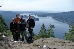
Diez Vistas 21/03/09
Michelle on Diez Vistas:
“Tres Hombres & Un Bebé, Más Dos >> John, Erez and Eric joined me for a fabulous day of pure sunshine and clear views of Vancouver and the lower mainland, Belcarra and Deep Cove, Seymour and the white crested neighbouring mountains and Indian Arm. We all indulged in a little sun basking and eagle watching on the bluffs at viewpoint uno after lunch – at which point we picked up two additional Wanderung fellows who joined our band for the rest of the day. Along the ridge we encountered a few stretches of snow but the patches were shallow, compact and easily tread on – save for a couple steep parts, which poles proved useful on. We still did better than book time. The trail was in great shape with next to no mud and several other groups of hikers were out on the trail. Spring is here and so is hiking season!”
Diez Vistas 16/11/08
Michelle at Diez Vistas:
“The weather people got the days reversed (Sunday and Saturday got each other’s forecast). The rain held off and it was nice and mild, but our band of 6 had 10 spectacular view points of … fog! It promised to clear at lookout 0 as we watched the horizon line and cloud separate, but the ridge became re-enveloped (although we managed to sneak a view of Baker from the Eastern view point). Instead we enjoyed the tranquil misty rain forest trail in all its mossy glory. We surprisingly had very little company on the trail even though the trail was in fine condition and the first parking lot was full (guess everyone was down on the lower trails). Note: Construction is posted as blocking the Eastern side of Trout Lake and the short cut junction at the Northern end of the trail by the log crossing isn’t marked – we took the long way down right to the end of Diez Vistas at the end of Trout Lake where it bottoms out onto the road. Six hours round trip including extra West to East viewpoint loop laps. One quart of ice cream down, 14 to go.”
Lindsay Lake 30/03/08
Hurrian P. at Lindsay Lake:
"Like most great trips, this one didn’t really go as planned, but the day’s adventure made it worthwhile. As we started to ascend up from Buntzen Lake I doubted that we needed snowshoes but by the time we got to the ridge there was 8 feet of snow. We followed the tracks of some errant snowshoers and somehow wandered off the regular trail to some place to the east of Eagle Peak. Luckily we bumped into a mysterious older man named Bob who looked like he had stopped aging a decade or so back. He confirmed that we were nowhere near the Lindsay Lake trail. (All of the signposts were buried.) He said we could find the proper trail again but we’d have to bushwhack through the forest among very deep tree wells to get there. He led us past Cypress Lake and to a great lookout over the eastern Lower Mainland before depositing us back at the proper trail. I think the trip demonstrated the need to also bring a topographical map because 103 Hikes, however good, does not provide sufficiently detailed maps."