Category Archives: Snowshoe

Wedgemount Lake 01/05/11

Dan at Wedgemount Lake:
“Finding ourselves with more sunshine than forecasted, we upgraded our destination and headed to Wedgemount Lake for this glorious weekend. The snow was vastly more abundant and better than last winter; there was hardly any no iciness. A congenial group of seven with varying levels of experience, we snowshoed the entire way with only minimal slipperiness. Routefinding did not pose any problems on this trip.

We reprised last spring’s approach and headed up a ridge beneath Mount Cook – descending back down onto Wedgemount Lake – and bypassed the steep and avy-looking summer route. Once at the lake, we witnessed a few cornice-triggered avalanches. Calum videoed one and it is posted on the Wanderung Flickr site.

Three of us then headed across the lake and onto Wedgemount Glacier. We were awestruck by the vast jaggedness of Nature’s beauty, with brilliant vistas and rugged wonders in every direction that took our breaths away! Let me tell you, this is a must-see winter locale if pristine alpine nature is your thing. We did not run into a single soul the entire day! More photos on my Live Trails report.”

Wanderung trip to Wedgemount Lake, May 1, 2011

Mt Rohr 26/03/11

Ben V. on Mt Rohr:
“The wind was calm, the skies were blue, and the snow was perfect for snowshoe travel. We left the city eager for some time in the alpine. The route to the lake was mostly easy to follow along tape, ski tracks, and some nearly buried orange markers. We found the sign for the turnoff to Rohr Lake just above the snow at ankle height. A bit of routefinding was necessary from this point up to a small clearing below the lake. From the lake it was smooth sailing straight up the valley floor with plenty of alpine scenery to enjoy. We approached the summit ridge from the northwest and took a nice line to the top with only one excessively steep section requiring us to drop down on all fours. The summit was surprisingly hospitable and we were able to sit down and recharge while we soaked up the panoramic views. A big thanks to Adrian and Dan for making this a great trip.”

Mt. Rohr, March 26, 2011

Lost Lake Shelter 26/02/11

Robert D. at the Lost Lake shelter:
“Originally planned as a 2-day, we decided to condense this trip into 1 day with an earlier start. Three of us assembled at 6 am and made our way to the handy parking lot just south of Porteau Cove, the access point for the northern end of the Howe Sound Crest Trail. The trail to Lost Lake shelter follows Kallahne Creek. The route on the ascent was very slow going due to trail breaking in heavy powder. The trail is not the easiest in any condition due to numerous awkward creeks crossing it. It took us 5.5 hours to reach the shelter which was a welcoming place to rest for a late lunch. The shelter itself, situated on the western edge of Lost Lake, is rustic but reasonably maintained and can hold about 6-8 people. The conditions and bad visibility negated any chance of continuing to Deeks Peak but an overnight trip to the bag the peak would be worthy of a future call out. The descent took just 2.5 hours.”

Alouette Mtn 19/02/11

Ben on Alouette Mountain:
“The day was bright and the trail was long. If you are seeking a route that offers some views along the way, look elsewhere. Prior to reaching the summit there is basically nothing to see except stretches of old access road. The portion of the trail that overlaps with the old road is well marked, with wooden signs indicating the turn off points. Beyond the final turn off the markers are a lot more sporadic. Bring your route-finding and tape-spotting skills. We were lucky to be passed at this point by a group of locals who blazed the trail forward. The snow was in good condition. It was fresh but beginning to consolidate. At the top we enjoyed the close up view of the Blanchard Needle, and then retreated from the wind to have our lunch in the shelter of some trees. Thanks to Adrian and Lori for joining me.”

Mt St Benedict 05/02/11

Ben on Mt St Benedict:
“We stayed dry but we have no views to report from this trip. The clouds that hung on the ridge in the morning did not break for us. This hike has potential as a nice winter alternative to the popular North Shore standards. It is accessible in any vehicle and the trail is easy to follow. If you go anytime soon, be prepared to lug your snowshoes up a few hundred metres before finding any snow however. There is also a section of logging road/stream bed to expect. The turn-off of the trail from the road is marked by an old pan, and is pretty easy to spot. We put on our showshoes around McKay Lake and picked our own trail up the ridge. The snow beyond the lake was crusty. Atop the ridge we headed south towards the summit, seeing occasional markers along the way.”

Mt Sproatt 19/12/10

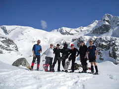
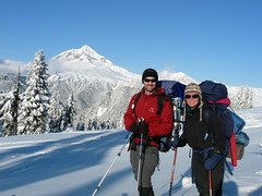
Irina on Mt Sproatt:
“Our hopes for the afternoon clearing were not in vain, as drizzle over Vancouver turned into flurries along the Rainbow Lake trail, and then gave way to patches of blue sky as we were hiking up higher.

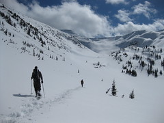
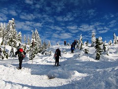
The Rainbow Lake trail was easy to follow with multiple ski tracks. The question was: where to turn off west? Last time I was here, we turned off at the 4.5 km mark before the wooden bridge (https://www.livetrails.com/report/847/0/Mount_Sproatt). This time, we carried on further and turned off at the outhouse. Arriving at the cliff with a massive yellow icicle, we headed up the steep slope. Snowshoes provided us with good traction, but a group of skiers struggled and, after a few unsuccessful attempts at skinning up, took off their skis and were trying to bootpack up. Surprisingly, there were no tracks whatsoever past that point, and we broke trail towards the alpine, in anticipation of open skies.

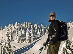
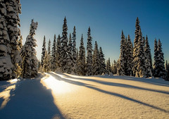
Soon enough, we were out of the trees! With no apparent peak on the horizon, we continued our way along small ridges in the direction of the GPS-indicated summit. While no signs of avalanche activity were visible, the whoompfing under our feet called for frequent group discussions and conservative ascent lines. Buried below the top 20 cm of loose dry storm snow, was a 5 cm rain crust from the weekend before that was giving way. Arriving at one of the summits 4h 15min after the start, we decided to not go around all four of the seemingly identical bumps in search of the slightly higher one, but instead enjoyed the views of the Armchair Glacier, Wedge Mountain, Whistler and Blackcomb on the other side of the highway. A beautiful winter day!

We were wondering all the while where the skiers disappeared to, and got our answer after descending back into the trees. The untouched snow just above the yellow icicle cliff turned into a maze of ski tracks. The descent was a breeze: took us under 2.5 hrs from the summit to the vehicles, and that’s on snowshoes: would have been much faster on skis! Back before dark and off to the Fish’n’Chips place in Squamish. Excellent team trail-breaking and route-finding discussions made it a safe and enjoyable trip. See mine and Dan’s reports and pictures on Livetrails: https://livetrails.com/index.php?viewTrail=1&trailid=1082.”

Mount Sproatt 19.12.2010 133

AST-1 Course 04/12/10

Steve on the Canada West Mountain School AST-1 course:
“Ten of us joined another 22 people in a course mixing skiers and snowshoers for our AST-1 (basic avalanche) certification. At first I thought the class size was large but what it did was expose us to 4 instructors from a variety of backgrounds.

The classroom component on day one was just the right amount to hold our attention and give us the basics and then it was out to the snow on the first of 2 and amazing Seymour days!

Saturday and Sunday we covered: snow testing, companion beacon rescue, avalanche terrain recognition and more.

A big thanks to John, Linda, and Steve from Canada West Mountain School for the break on price, and all of the wisdom they passed on to us! I highly recommend this course for anyone interested in winter backcountry travel. It wasn’t just educational, it was a blast!”

AST-1 hiking up to the field test

Taylor Meadows 27/11/10

Chris M. winter camping at Garibaldi Lake:
“We broke trail the entire way. Along the road, up the trail, in the meadows and up the ridge. Around 25 km round trip. Scott and Ian were in snowshoes. I skied. I was so tired I buried my heavy tent at the 4-km marker and decided to sleep in the shelter. We missed sunset. Exhausted, we played cards, went to sleep early and still we missed sunrise. We woke up to frozen ski boots and gaiters. After skinning up the ridge, just as the views opened up, along they came including Robert!? – a Wanderung member who decided our tracks looked better than breaking trail over to Panorama. Smart choice. After stopping with a beautiful view of Black Tusk another Wanderunger, Adrien showed up!! The morning had been a bright blue but the clouds now started to roll in. Skiing down in 2 feet of powder was dreamy.”

Overnight on Skis

Elfin Lakes 20/11/10

Rob M. at Elfin Lakes:
“We made it to the unploughed upper parking lot. One car had slid off the road into the forest – a bit of bumper and windshield visible – driver frantic on the cell phone. We seemed to be the first, breaking a snowshoe trail out to the hut. Progress was slow and draining. From the high stilted outhouse at Red Heather I could see that the poled winter route hadn’t been set. The narrow trail followed the summer route without any avi risk. We arrived quite late at the Elfin Lakes Hut feeling a little trashed. Sadly there were no tracks leading up Columnar Peak/Gargoyles saddle. Time worked against our intent of tenting out on the saddle, Columnar Peaks or ideally up on Little Diamond Head. The trump card was yet to be played.

With less than two hours of daylight a couple of skiers headed out towards the saddle but gave up breaking trail 1 km beyond the shelter. At the shelter I saw three grommets had broken loose from the metal frame of my MSR snowshoes. That and the oversized winter pack were probably the cause of some shooting pains in my hip. Three steps in 1.5 metre snow from the hut there was a collective feeling that we didn’t consume enough power gels to get us to the saddle.

A half hour later Glen tells us that his bivy setup probably wouldn’t work. The temperature was -15 and dropping – colder with the wind chill and worse at higher exposed elevations. We quickly found a spot in the meadows at the base of Columnar Peaks and began digging out a campsite and talked about what to do if the temperature went south of -20. Two of us ended up sharing a 4 season Hilleberg tent and with a bit of tweaking, everyone survived the night – woken once by the sound of snow drilling our tents; and once by the unmistakable sound of a woomph and a slide coming down the Gargoyles.

We took a mellow, get lost and smell the flowers pace back to the parking lot passing more than 50 skiers/snowboarders on Paul Ridge near Round Mountain. The trail was now a super highway. A pint and burger in town and we were home.”

P1100587