
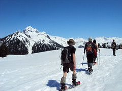
Alex P. on Hollyburn and Mt Strachan:
“Ten Wanderungers took part on a great Sunday afternoon snowshoe trip in the sun via the Hollyburn-Strachan traverse loop. The group included the 3 Dans (Dan, Daniel, and Danny), Hilda, Rita, Sigrid, Sophie, Brad, Callum, and Alex. Bluebird day that it was, both the parking lot and the Hollyburn trail were rather packed. Once we ventured past Hollyburn and descended onto the Hollyburn-Strachan trail we left the packed crowds behind and were rewarded with solitude with Nature the rest of the way. The big dump of fresh powder Friday made for an extra workout but was gentle on the knees. Saturday allowed for the snow to settle reducing the avalanche risk to low. We couldn’t have asked for better conditions. The powder made sliding down Hollyburn loads of fun. I am pretty sure that Sophie woke up a few hibernating bears with her scream as she slid down. There is sufficient snow that most of the trail markers are covered so diligent route-finding was important. Callum and Danny did most of the trail-breaking up the steep slopes. We were all very appreciative of their hard work while we stayed back and suntanned. The views from Mt. Strachan looking out to the Gulf Islands and the high mountains all around were spectacular!”
Category Archives: Snowshoe
Mt Seymour 27/01/12
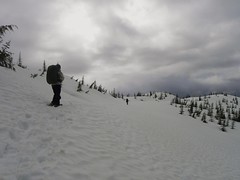
Michel on Mt Seymour:
“We started our snowshoe excursion with an unexpected foggy and windy day. We rapidly got warm going uphill. The trail was fairly packed with some fresh snow on top. The view was blocked during our way up and we couldn’t see a thing arriving at the end. We came back down a litte bit to take a lunch break away from the windy conditions. On our way back, the wind died down and it cleared up so we could have a nicer view coming down. The trip went according to plan, except for the weather, and we finished the day in a local coffee shop with great company throughout the day. A great first experience for us! Thanks Perry for organizing this trip.”
Keith's Hut 21/01/12
Dennis at Keith’s Hut:
“From the beginning, this was a hike full of warnings and red flags. The Duffey Lake area is known for avalanches. Going into the weekend the Canadian Avalanche Centre had a high avalanche warning for the region. On this note, I received more than one stern warning from concerned Wanderungers. Nevertheless, four brave souls (Ian, Liz, Calum and Rita) joined me on this ominous trip.
Recent heavy snowfall and cold weather have made the Sea-to-Sky north of Squamish a nightmare for anyone not equipped with a 4wd or chains. As we drove towards Squamish, the warnings continued with Mountain Radio describing the road past Squamish as a sheet of ice and to avoid driving in that direction if possible. The drive up was a slog in stop and go traffic through a couple different sections on the highway due to accidents. If you plan on heading to this region in winter weather, be prepared for these kinds of delays, especially on weekends when many inexperienced drivers head up to Whistler. In total, the delays added 2 hours to our travel time which I had not anticipated.
The parking lot is a pullout just off the highway and was easy to spot with 3 other cars already parked there. The hike up to the hut was straightforward on a well-marked and frequently used trail. The new snow however made for a bit of a workout breaking trail. The evening was spent pleasantly socializing and drinking wine with seven other backcountry skiers also staying overnight. Great location and lots of firewood. Despite all of these amenities, Calum feeling more adventurous and much more energetic than the rest of us, dug a snow cave and slept in it overnight.
The next morning we quickly ate breakfast and left the hut with plans to do some light exploring before returning to the car. I had all but abandoned my original plans to summit Vantage. But, after judging the snow conditions of the route leading to the Matier-Vantage col, we decided it was safe to make our way up to the col. The trail and cairns marking it are hidden under snow at this time of year, but a route is fairly obvious nonetheless. It took us an hour to the col and back. At the top we were rewarded with spectacular views of what I assume was Joffre Peak.
The drive back was again sluggish due to winter road conditions and accidents. So, I repeat, do not attempt to drive here without a 4wd or chains. Finally, I cannot say enough good things about everyone who joined me on this hike. All strong hikers who radiate positivity. I would recommend them to any organizer. Thanks again guys for making this a great trip.”
Mt St Benedict 18/12/11
Irina on Mount St. Benedict:
“This last minute trip only found three participants as we got out for a hike, hoping the forecast will be correct and it actually clears up in the afternoon. No such luck, just the teasing blue patches of sky running above our heads.
Gravel road, albeit with some pot holes, is in good condition for a 2wd. Took us less time than expected to get to the top, only 3 hrs: lack of snow over the last 2 weeks and only 5 cm of fresh powder from the night before meant that the trail was fairy well consolidated. It appears to be quite a popular place, and the existing track sure made our hike a lot easier. Boots to the lake, snowshoes from the lake to the summit and crampons for the way back (some portions of the trail between the summit and the lake are quite steep). Logging road is a running stream but one can still find dry rocks/low water to not soak the boots. Must be a nightmare during the spring melt.
Contemplated going to the nearby North summit (McKay Peak) but none of us were much motivated given low visibility. Good day nonetheless, as at least it didn’t rain or snow on us and we were treated to warm temperatures and lack of wind. A bit too long of a drive for such a short hike and no views, though. Trip report and photos on LiveTrails.”

Elfin Lakes 04/12/11
Dan at Elfin Lakes:
“Eight of us headed out bright and early to Squamish and drove up Mamquam & Garibaldi Park Roads to the Diamond Head Trail parking lot. We had a 4×4 with 2 set of chains and a 2wd truck with one set of chains – both made it up easily with no traction issues.
Blessed with recent dumps of fresh snow in late November, we put on our snowshoes right away. 1:15 later we were at Red Heather Shelter basking in the warm winter sun. The winter route to Paul Ridge was well-trodden and there were many groups of AT skiers – and only one snowshoe group – that we hiked past on the way up.
Countless photos and 3 hours later we started descending on to Elfin Lakes. Both lakes were solidly frozen – early by normal standards. There were easily 3-4 metres of snow at the shelter. Surprisinigly, only a couple of parties remained and it was fairly quiet inside. We lingered for an hour, soaking in the warm sun, and made our way back. Headlamps were used only for the last 45 minutes. And we treated ourselves to a great meal at the Shady Tree after, conjuring up next week’s adventure at the Musical Bumps.”
Empetrum Peak 12/06/11
Irina on Empetrum Peak:
“After breakfast at Galileo, our group of four started the hike from the Cheakamus Lake parking lot. A 2 km trip to the turn-off for the bridge across Cheakamus River, and the trail starts climbing up. Consistent snow started at 1080 m, near the end of switchbacks. Most of the snow was firm enough to walk on in boots as some older footprints suggested, but after each of us postholed all the way to the thigh, putting on the snowshoes was a unanimous decision.
It was a long but pleasant hike following the markers where we could find them. In 3 hours, we were at the meadows with first glimpses of mountain ranges around us. Heading west, we chose our ascent route which climbed to the saddle between two of the subsummits. Good snow quality due to lack of sunshine certainly helped, and after another uphill, we were on the ridge. Claudio and Malin chose to stay there, and handing them one of our radios, Evgeny and I continued to the Empetrum peak. It was only another 30 min to the summit, where we were treated to the close-up views of Black Tusk from this rarely visited vantage point.
After rejoining, we tried another route on the southern side of the ridge for the way back. Would have been doable with crampons and ice axes but not all in a group had them, so we retraced our steps and descended an even gentler grade along the ridge. Stayed too far west in the meadows though, and ended up crossing the creeks hiking down and up steep-ish embankments.
A good hike and fun conversations along the way made it an excellent outing. Thanks to Claudio for offering to rent a car and drive. See trip report with geotagged pictures on Live Trails.”

The Gargoyles 05/06/11
Irina at the Gargoyles:
“Ah, finally, the summer is here! Bright blue skies and snow-clad mountains are calling 🙂 Our group of nine started off from the Elfin Lakes parking lot. Snowshoes, although not strictly necessary, went on from the start. We used the winter route along Paul Ridge, and with stops for snacks and pictures, made it to the Elfin shelter in just over 3 hours. Atwell and Garibaldi were seen from many vantage points along the trail, and we were excited to be getting even closer.
For four in the group, it was a second day out in the baking sun, and they opted for staying at the shelter, while the rest of us were eyeing the route to our destination. The decision was made to go up the safe zone until the end of the tree line, then re-assess the traverse below the steep East face of Columnar Peak from there. Instead of the dreaded sugary snow, we found ourselves walking up firm and well-settled snow. Although moist, it held well. From higher up, the traverse looked much more approachable: the longer-propagating sluffs off Columnar were old, and the fresher ones were short runs-offs at the highest steepest portions of the ridge. We continued on to the Columnar-Gargoyles saddle.
The ridge up Columnar Peak was narrow and heavily corniced, while that of Gargoyles, quite a bit wider. Up we went, reaching the West summit of Gargoyles in about an hour of travel from the shelter. Views of the cornices on the East summit killed any desire to explore that peak. Without regrets, we called it a day and relaxed and enjoyed another hour of the beautiful sunny day on the top, surrounded by mountains, breathing in the warm summer air for the first time this season. A tiny speck of a solo hiker was moving towards Little Diamond Head, and the vastness of the white space around him was intimidating.
Returning to the shelter, we re-joined our group and headed back. I hope all enjoyed a great day in the mountains; I sure did, and a wonderful company was certainly a big part of it. Huge thanks go to our drivers Susanne and Darcy. See full report and geotagged pictures on Live Trails.”
Mt Gandalf 21/05/11
Ben at the Brian Waddington Hut:
“Despite the dramatic disappearance of the sun this weekend, our group of five met up and headed north with hopes of finding clearer skies. The road to Birkenhead Lake was clear and in good shape all the way to the lake. We turned off at the branch immediately before the gate to the campground and parked nearby, facing 6.6 km of logging road to walk to the trailhead. Along the way we passed up a VOC group heading up with skis on their backs. At the end of the road we had lunch and let the skiers take the lead. The trail was short and very well marked as it winds up the forest along Phelix Creek. It was however challenging in the soft melting snow with heavy packs. Eventually we crested a small rise to see Long Lake and the hut awaiting us at the far side. The weather had been grey all day and it didn’t look like the situation was any more promising up here. The hut deserves its good reputation. The evening was a relaxing mix of cooking, reading selections from the library, and enjoying the skiers’ renditions of old Bob Dylan songs on the guitar.
The next morning the snow was falling and we left the hut to stretch our legs. We had no real expectation of reaching any summits, but we decided to make for Gandalf-Peregrine col and see what things looked like. After a couple of hours we found ourselves at the col having the turn around time discussion. We had plenty of extra time so we decided to invest another hour and take it a step at a time. We began to switch back up the end of the ridge leading to Mount Gandalf. We couldn’t see much but we knew that up there somewhere the white wizard was waiting. Progress was steady thanks to Brad’s trail breaking effort, and before we knew it we found ourselves standing below huge boulders. With less than 100m to gain, we knew we must be close. From here Pavel lead us on a true showshoe scramble as we moved up bare slabs, boulders, and the snow that filled the gaps between, not bothering to stop and remove the snowshoes. One final block split the group into three as we picked our preferred routes over or around the rock. After converging and counting heads, we moved on. Then out of the mist appeared the great unmistakable flake standing like the final stone on some great summit cairn. We were there! Congratulations all around! A huge thanks to Brad, Pavel, Rob, and Darcy for their contributions to this very memorable trip.”

Panther Peak 21/05/11
Ahmad on Panther Peak:
“I was first surprised by the lack of signage to the park. I expected at least the regular provincial sign that I am used to seeing in provincial parks. Second, I was surprised by the lack of people especially for the long weekend. There are four cabins in the park and I think the park is underrated. We only saw 6 people in total.
I wasn’t aware of NcNair Cabin which was a treat to find near our destination. It seems most people in winter head to Edwards Cabin and some to Steele Cabin. The trail to Edwards Lake was broken but there was again lack of markers but might just hidden in snow. It could be better in summer.
After Edwards Cabin, we broke the trail towards Chapman Lake. The trail crosses Chapman Creek about half way but we missed the turn and we became on the other side of the lake. We reached a creek that we couldn’t cross. We had four options: return to Edwards Cabin, turn back and look for the bridge that we missed, camp where we were, or cross Chapman Lake. We chose the last one. The lake was melting in some sections but we managed to cross it without a problem but I expect it will not be crossable any more soon. McNair Cabin was in good condition and it is located truly in serene location.
Our objective was to summit Panther but I was pretty exhausted from the night before. I also had some concerns of crossing the lake on the next day and the tight schedule for the ferry. I think this is an awesome place to spend an overnight if not more.
Photos, movies, and GPS track on Live Trails.”
Coliseum Mountain 08/05/11
Ben trying for Coliseum Mountain:
“It is a bit too early in the year to find favourable conditions on this hike. The snowline was at approximately 825 metres and the terrain at this point on the trail is quite rugged. Ugly postholing and slushy snow on the steep slopes made for an unpleasant time. We reached Paton’s Lookout to find ourselves in the middle of a thick cloud. There was only a slim chance that the weather or the snow would improve if we continued, so we decided to turn back and call it a day. I look forward to returning here later in the year.”