
Ahmad on Overlord Mountain:
“What amazing views from Overlord! The ascend was harder than I expected. Top of Refuse Pinnacle was covered by fresh snow and its slope lured us to traverse it. It seemed it was possible from looking at it from a distance and the topo map. We traversed a long way on a series of small gullies and ridges with many loose rocks till we reached a point, we found that it was hard to continue. We decided then to climb up to its top which was a hard climb but then we were relieved to find that its narrow top ridge was a much better option. The snow made it slippery but I think if it was dry, it would have been easier. The rest of the way was easy. It took us 4 hours to go up and 3 hours to get down from Russet Lake. I also find Whirlwind Peak provides nice views and it could be a destination by itself if you don’t have the luxury of time. It is also an easier option than Fissile Peak. On Saturday we met a few small groups camping on Russet Lake including two former members from Wanderung. The four of us had an excellent weekend. No ice axe was needed to get on Whirlwind ridge. Thanks for Tim and David for their information and tips.”
Category Archives: Backpacking
Grand Canyon 25/09/08
Sue in the Grand Canyon:
“The 3 of us started out at sunrise down the North Kaibab Trail taking the side trip to Roaring Springs to cool off in the water. Ribbon Falls was the highlight of the first day after setting up camp at Cottonwood and playing in the creek. Setting off at daybreak again on day 2 got us to Bright Angel campground well before lunch with time to relax at Boat Beach before hiking the River Trail loop for more fabulous views. On our layover day we hiked almost half of the 9 mile Clear Creek trail, a very hot trail even on a day with some cloud cover. Lots of sun exposure and great views from this trail. After lunch Ribeka and Lucy also visited the waterfall at Phantom Creek and did a very worthwhile exploration further up the creek. Wildlife included 2 rattlesnake encounters and 1 sighting. Scorpions and a black widow spider were revealed by Ranger Pam at one of her several informative talks at Phantom Ranch. Great weather with t-shirts for all except the first hour from the North Rim and very warm nights. Hiking out the Bright Angel Trail for the first 2 hours with headlamps allowed Lucy and Ribeka to venture quickly out on the side trail to Plateau Point for sunrise before the final 5 mile uphill stretch. Early rising was worth it to avoid the extreme heat of the day. A 4am start got us up to the South Rim well before 11am hiking in almost total shade. Lots of chit chat with the many tourists on the upper section of the trail. We were reportedly the only hikers with smiles on our faces at that point and we were sad to have the trip coming to an end so soon. A great trip and couldn’t wish for better company. You can’t help but love the Grand Canyon for all its fabulous expansive views every step of the way. I expect we will all be back to explore more trails here in the future.”

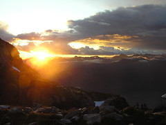
Russet Lake 13/09/08
Heather at Russet Lake:
“Laurie, Ming, and Kim joined me on a great overnight trip to Russet Lake on Sept 13 & 14th. The weather was glorious allowing for great views of the mountains behind Blackcomb, Whistler and the Garibaldi Lake area. The hardest part of the hike is getting through the armour-clad mountain biking mobs in Whistler village and finding the start of the trail. It took about 5 hours up, the first three on a gently rising forested path, the last part opening out into Singing Pass and over the crest to the lake. The trail had a few washouts in places, but nothing too hard to get past. The hut at Russet Lake has been `renovated’ so the door closes and there was no sign of mice! A spectacular moon rise over the mountain was a highlight. Day 2 had us hiking up & down the musical bumps to Whistler peak where we took a free ride down the chair to the restaurant, had some drinks and then took the gondola (free again) down to Whistler village. Although it saves the knees from having to do all the downhill, it’s a bit disconcerting to arrive at the top and suddenly be amidst crowds wearing flip-flops, mini-skirts, etc. – like a glorified Grouse Grind. We had some debate over who would prefer to hike back down the original trail instead. A recommend hike for an `easier’ overnighter with beautiful views.”
Golden Ears 13/09/08
Andy on Golden Ears:
“Without doubt the views from Golden Ears and its very own Panorama Ridge are unsurpassed in the Lower Mainland. But make no mistake: this trail is hard with an overnight pack. Once above all the nasty stuff on the lower trail (described in Astrid M.’s report from 31 Aug), the trail is beautiful, passing through wonderful mixed old-growth forest on its way to the sub-alpine, although it’s not without several steep, challenging sections. Then you reach the final never-ending ascent to the emergency shelter and the fantastic views. Unbelievably fantastic. We opted to relax for the rest of the day and go for the summit on Sunday. That didn’t quite work out, thanks to a little exposed ledge, and only Maria earned the full 360-degree experience, while Merewyn and I searched unsuccessfully for an alternative approach. Next time… A ghostly pink moonrise, a brilliant sunset, moonlight so bright that headlamps were unnecessary and then the most fabulous of sunrises made for an unforgettable trip.”
Hurley Silver Mine (Blackwater Trail) 13/09/08
Chris in search of the Blackwater Trail:
“Another small group with Cara and Lucy joining me on an exploration of the ridges to the east of Common Johnny Creek in the Cayoosh. Parking was on the north side of the Duffey Lake Road at a gravel pullout just past the Blowdown road. Cayoosh Creek is crossed by a footbridge (with various obstacles designed to stop motorized access). Just over the bridge, a right fork leads to a First Nations protest camp (and, as far as I know, the start of the new WCWC trail up Melvin Creek). We turned left and took the uphill option at all forks beyond that. After the first switchback, there is the remains of a burned bridge but the creek crossing is pretty easy. We reached the site of the old winter cabin (also burned but the outhouse is in great condition) in the alpine bowl in 2 hours – all travel to this point on roads. Here we climbed up a steep(!) meadowed gully on the north side of the valley to reach our camping spot near a small lake (another 35 mins). From here, it was 15 mins to the ridge of the Common Johnny Creek and views in all directions (including to peaks near the Stein and Garibaldi and to Whitecap and further peaks in the Bendor). We spent a good portion of Saturday and Sunday travelling the ridge from a point above Duffey Lake to overlooking Barkley Valley. Walking was easy except for one step that would require confident scrambling skills for 10-15m on crappy rock. The meadows to the east of the ridge also provided easy travel and probably a few good camping spots. All the meadows were a light golden and the blueberries bushes provided patches of red and orange. Only Mountain Monkey Flower and some sheltered Paintbrush were still in bloom. Lower down, the raspberries and thimble berries were ripe. Unfortunately, the Blackwater Trail eluded us. Given the steepness of the meadows in Common Johnny, it’s possible that the trail didn’t cross over our ridge but somewhere else; or was in a completely different valley.”
Garibaldi Lake/Panorama Ridge 06/09/08
Su-Laine at Garibaldi Lake and Panorama Ridge:
“Seven hardcore backpackers plus myself headed up to Taylor Meadows on Saturday. Three went up to Black Tusk that afternoon while us other five mere mortals enjoyed a gentle walk to Garibaldi Lake. After surviving a freezing cold night and morning, when the main topic of conversation over breakfast was winter sleeping bags, we all headed to Panorama Ridge on Sunday. We had the incredibly good luck to be doing this trip on a clear weekend with blue skies, and Panorama Ridge was the most eye-filling hike I’ve ever done. September seems to be a good time to do this trip; the trail was dry, some of the wildflower show was still happening, and there were plenty of good campsites at Taylor Meadows.”

Mt Gardiner 06/09/08
Tim on Mt Gardiner (NOT Mt Gardner!):
“Tim and Dean climbed Mount Gardiner (2406 m) above Place Glacier on Saturday Sept 6th. We drove up to Pemberton on Friday night after work and camped at at Nairn Falls. On Saturday morning, we ate excellent bacon and eggs at Grimm’s Gourmet on Frontier St. at 7am and were at the trail-head by 9am. The hike to Place Glacier is 1400 m and very steep. It takes about 4 hours. Worth every drop of sweat. There is an impressive waterfall early on. Also a tricky headwall just below the glacier that requires scrambling some narrow ramps with a little exposure. Place Glacier is phenomenal. From the Glaciology Huts (1800 m), it is another 600 m (2.5 hours) to the summit of Gardiner. Matt Gunn’s book is very useful. The mountain is a superb ridge scramble with no real exposure. The weather was good. The views were outstanding. On Sunday we set off to scramble Mount Oleg, but stopped halfway there, at a sub-summit on the NE ridge. Axe and crampons proved useful on the second day. To reach the summit probably requires crossing a glacier with associated hazards. There was much evidence of mountain goats (fresh prints) but no sightings.”

Blowdown-Van Horlick divide 06/09/08
Chris at the Blowdown-Van Horlick Divide:
“Jana, Peter and I braved the unknown to visit what turned out to be a beautiful untouched wilderness on the Blowdown-Van Horlick divide. The Blowdown road was in good 2wd condition – some minor rutting and a new culvert at 9 km. Also, a new waterbar on the hill past 9 km and possibly more further along (you may have minor scraping in a 2wd). We intended on taking Branch 4 at 9.5 km but it has just been decommissioned – the culverts and bridges have been pulled and a big rock blocks the road at the start (but could be avoided in a narrow 4wd). The road has been copiously waterbarred (5 in 20 m at one point). We walked the road to the end (just before an avalanche path – perhaps 2 km), bushwacked 100 m and climbed a second avalanche path about 400 m to steep meadows. We sidehilled to the upper valley (tricky due to wet plants) and wandered beautiful meadows to the pass. Descending into the next valley, we camped near some small ponds. In the morning, we checked out the main lake (beautiful) and spotted some mountain goats high on a ridge. We meandered back up to the pass along a different route and descended back into the Blowdown valley along the edge of the scree slopes (lots of rocks and a short brushy bit just before a wetland so slow going). Definitely going back and spending some more time exploring what looks like easy ridges to the NW.”
Golden Ears 31/08/08
Astrid M. at Golden Ears:
“It took our group 7 hours to reach the small emergency shelter. Recent wet weather created several muddy patches and made the roots and rocks slippery. One bridge over a creek is broken and slanting down southwards (hold onto the north handrail). A good part of the lower trail is more a creek bed than a trail, meaning lots of loose rocks. After setting up our tents at around 5:30 pm we heard distant thunder. Three of us decided to try to summit before the storm moved in but got turned around by hail and lightning. Luckily the sky cleared and we were treated to one of the most beautiful sunsets I have ever seen. The next morning we awoke in a cloud. We waited until 11 am to see if the sky would clear, but visibility stayed poor so that the summit was not possible. We returned to the parking lot in 6 hours back.”
Stein Valley mini traverse 30/08/08
Merewyn in the Stein Valley:
“Pictographs, cable cars, unlogged old growth forests, a beautiful clear river – the Stein Valley has it all and more! Andy, Maria, Christian, and I spent a wonderful week traversing the Stein from Blowdown Pass to Lytton. The trip started out with intense snow flurries at Blowdown but once we got over the pass and down into the valley we had great weather. We saw no large wildlife but we did see lots of squirrels, mice, ant lions, lizards, and snakes. In fact, we saw as many snakes as we saw people – once we left the Pass, we only saw 8 other people and had every single campsite to ourselves. The section between Blowdown and the Stein is obviously very under-traveled as we saw no other hikers and counted 76 trees blocking the trail within an 8 km stretch. The main Stein trail was infinitely more maintained. An unforgettable area!”
![Stein Valley - Thurs, 04.Sep [Day 6]](https://farm4.static.flickr.com/3255/2836686687_f580a76934_m.jpg)