Category Archives: Backpacking

Joffre Lakes 30/08/08

Anne at Joffre Lakes:
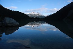
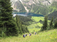
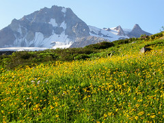
“Three of us took off on the Labour Day weekend for an overnighter trip to Joffre Lakes. The last part of the drive from Pemberton to Joffre Lakes Park was quite painful because we had 3 (!) RVs in front of us – so it seemed to take forever to get to the parking at the trail head. Once we started hiking we were accompanied by light rain most of the time; but it wasn’t too bad because the sun was poking through at the same time. At the second lake we had a pretty dramatic encounter: Kim got attacked by a Whisky Jack and had to give up an entire chocolate bar to the vicious bird! We still made it in pretty good time up to the Upper Lake and arrived early enough to find great camping spots right on the water. By the end of the day almost all camping spots were taken – it sure is a popular destination for a weekend. We had all sort of weather; sunshine, rain and hail. Unfortunately there was not much of evening entertainment possible because it just kept raining and hailing in the evening and it was REALLY cold. (Lesson learned: do not forget your toque!) The next day we woke up to great sunshine, after breakfast we set out to explore the glacier – well, actually we only wanted to walk up a bit on the ridge but somehow ended up right at the glacier. The cracking noise of the glacier and the terrain was a bit intimidating, but we got some great views. During the day the clouds moved in and out, on our way down back to the car we had some more rain. The trail was by then really muddy, so gaiters sure came in handy. Once we got back into the car and started driving back towards Pemberton we encountered a bear right on the street. We finished off a great weekend with a steak in Whistler before heading back to Vancouver.”

IMG_3253

Athelney Pass 30/08/08

Chris at Athelney Pass/Salal Creek:
“Attrition due to injuries and work commitments whittled our group down to just 2 but off we went anyway. The Lillooet River FSR is in good 2wd condition all the way to the Salal Creek Road. A creek was flowing over the road at 45.5 km which is probably doable by a confident driver in a 2wd with average clearance but depends on the time of year (earlier = higher water level). The hill beyond had a bumpy bit at the start but was good after that. At the top of the hill is the unmarked Salal Creek Road on the right (47.8 km). Most of the traffic on this road takes a right fork at 1.1 km to go to a mine – the route to the trail is straight over a shallow berm (may require high clearance). Two-wheel-drive traffic will be halted by the heavy rutting caused by water runoff at 1.3 km. We turn left at 5.3 km (straight leads to a new cut) and arrived at the trailhead at 6.0 km. The trail started at the far (north) end of the cut and is flagged by orange and pink flags (some initial confusion due to 2 parallel sets of flagging 10m apart – the best set is the uphill ones). A distinct footpath is rare but the flagging was good even in dense slide paths. Half an hour later we emerged on the gravel flats next to the creek. Whenever the creek hugged the east bank, flags led up into the forest to bypass the section (keep an eye peeled for them). There was one unflagged section of alder travel (100 m but felt much longer). Nearing the glaciers and after the recent rockslide, a faint footpath appeared close to the creek but disappeared after the first side-creek crossing. The 2 creek crossings are unbridged but we rock-hopped over them after scouting for a good crossing point. After that, the route traveled along a glacial moraine until it got too eroded and knife-edgy and we were forced down to the creek again. Much rock travel took us to the volcanic flats from where it was less than an hour to the collapsed cabin at the pass. Over the next couple days, it snowed, our boots froze solid, we visited ice caves at the toe of Athelstan Glacier, travelled down the boggy McPharlon Creek and climbed the Elephant.”

Tenquille Lake 23/08/08

Chris at Tenquille Lake:
“Cara, Dean, Lucy and Michele joined me on a trip into Tenquille Lake and to share the joys of west coast weather. The Hurley had just been graded so, though the surface was loose, the potholes and washboarding were gone. Branch 12 (the Tenquille branch) had some large water bars right from the start but the Isuzu Trooper made it through without a problem courtesy of Cara’s driving skills. The alder was pretty overgrown so we got some pinstriping but, on the way out, we met a couple guys who were in the process of cutting it back. The trail was in pretty good condition with only a couple blowdowns right at the start. Even with a stop for lunch (and berries) we made it to the lake in about 3 and 1/2 hours. After setting up camp, Dean took off to scamble Tenquille Mt. and Goat Peak (and saw goats!) while the rest of us went to Finch Ridge to gaze at the unlogged vista to the north. The next morning lived up to the worst of the forecasts Michele had seen for the weekend: “Rain, heavy at times”. It turns out that the cabin at the lake is in pretty good condition considering that it is 60 years old – kept the rain out and the resident mouse was fairly quiet. Wearing as much waterproof stuff as possible (Cara fashioned a poncho out of plastic sheeting from the cabin), we hiked out stopping only to graze on more berries (easier to pick with your teeth than with gloved fingers).”

Tenquille Lake 004

Elfin Lakes 16/08/08

Carollyne at Elfin Lakes and Opal Cone:
“Six of us hiked with our backpacks to Elfin Lakes on a hot, clear day with spectacular views of the mountains and meadows. Although it was busy at Elfin Shelter, there were enough bunks in the shelter for all of us when we arrived there at 1 pm. After unpacking and having lunch by the lake, we hiked out to Opal Cone, which turned out to be a bit of an adventure. As we began our descent to Ring Creek, we met a couple of hikers turning back saying the trail was gone, others who had made it but warning us to get as much water as we could. We continued on and found the slope must have had a recent landslide as the descent was what might be called a goat track in soft, dusty moraine. We made it down and then boulder-picked our way across the first fork of Ring Creek, with wonderfully clear water, across more rock, then finally across the bridge over the raging second fork. Going up the incline, the group separated, with the three fastest hikers scrambling up a direct route with difficulty. Ted and I found, then lost, then found the marked route with its long switchbacks – which we all used on our return. Atop the ridge, a stunning contrast was before us, with a green and flower filled bowl and a lovely trail which we followed to the end of Opal Cone ridge. Four did the last scramble up to the snow filled crater, while the writer enjoyed the view and the pikas (much larger than Columbia Ground Squirrels). We returned, very tired, to a now very full Elfin Shelter, by 7:30 pm. A full moon, three lovely kids and choral snoring stand out as memories. Sunday morning, with light showers chasing us, we returned home, glad we endured the heat to see Opal Cone on such a brilliant, if hot, day.”

opaltrailview

Joffre Lakes 09/08/08

Chris at Joffre Lakes:
“Somehow, I picked the worst weekend weather-wise this summer for an intro-to-overnighting hike. Even before we left on the drive up, our group of 10 had been whittled down to 6 – Colleen, Ivy, Jana, Peter, Roy and me. The skies looked ominous but when we reached the trailhead, the sun was trying to make an appearance. The trail was in good condition as we made our way steadily up. We had an extended break at the second lake where the ubiquitous Dean stumbled upon us. Just before the 3rd lake, the rain started and quickly turned to a drenching hail (dunno how that worked but it was hail and 2 minutes later I was soaked). For the rest of the trip, the weather oscillated between rain and almost rain. The worst of the rain was reserved for when we set up the tents. Before supper, some of us went up to the edge of the Matier Glacier and listened to it creaking slowly forward. The next day dawned wetly but we all enjoyed a couple side trips before returning to camp at lunchtime and packing up. The trail on the way down was distinctly wetter than before which slowed some of us down. The weather only started looking up again when we drove back into Vancouver. Monday is, of course, beautifully sunny. Figures.”

North Coast Trail 02/08/08

Sandra on the North Coast Trail:
“What an amazing week our group of 11 had on the 1-way 80 km trip through the newly opened North Coast trail and tried-and-true Cape Scott trail. We lucked out with only a few hours of light rain on 1 of our 7 days on the trail (4½ days on the NCT, 2½ days on Cape Scott, 2 travel days). There was lots of wildlife, with everything from bears and gray whales to a couple of porpoises playing around the front of our boat for 10 minutes during the water taxi ride on day 1 (and don’t get me started on the “whale-bear”).

Since we decided to hike the North Coast trail heading west, ending up on the Cape Scott trail, we did a 3 hour car shuffle at the end of day 0 to leave a couple vehicles in the Cape Scott parking lot (our end point). Our first day on the trail started with an hour-long water taxi ride from Port Hardy.

What was in store for us on the North Coast trail was apparent right away – straight off the rocks where the water taxi dropped us off, we had to haul ourselves up a steep embankment into the forest with the help of ropes. And – this was only the “moderate” section! The “very difficult” sections were great… ahh… for team building?!? Lots of muddy bluffs had to be scaled or descended with the use of ropes. The group did a fantastic job of yelling tips at people hanging from ropes on where to put their feet, passing backpacks along when sections were easier done as a pack-free scramble, hand-holding across sketchy sections, and of course taking pictures when people fell off the trail before helping them up (only after checking that it was just pride that was hurt, of course!).

I now have a new appreciation for the fact that a “minimal elevation gain” hike can be harder than summiting a peak! The NCT is a fantastic trail for anyone who wants to experience coastal hiking / loved the West Coast Trail, but wants a bit more challenge and no crowds. Kudos go to the folks that have punched this new trail through!!”

The ladies having a lunch break

Cape Scott 31/07/08

Carollyne at Cape Scott:
“Charlie, Curt, Lucy, Ribeka and I caught the 8:30 am ferry to Nanaimo for a rainy drive and dinner at The Scarlet Ibis in Holberg, before beginning the muddy trek to Eric Lake at 7:30 pm. It was hard to imagine what a `muddy trail’ meant before Cape Scott, but we were all glad we brought gaiters. Fortunately, Thursday night saw the last of the rain. Friday, we hiked out on the waterlogged, but lovely forest trail ­ giant spruce, stunted pines moss, ferns and the largest skunk cabbage I’ve ever seen – over boardwalks, bridges and mud to Nels Bight beach in bright sunshine, quickly throwing off our boots for a run into the ocean. Amy, another Wanderunger and a friend were there to greet us. That evening we sighted 3 grey whales blowing and fluking for several hours before having our first amazing 3-course dinner and sharing Amy’s campfire. We had heavy packs, but great food. Saturday, we day hiked to Experiment Bay, Guise Bay and the lighthouse, enjoying brilliant sunshine, stunning beaches, end of the earth views and interesting chats with the lighthouse keeper before another evening of whale sightings. Sunday, we were relieved to have a somewhat drier trail for the 18 km trek to San Josef Bay. While on the trail, the writer lept over a mudhole a little too recklessly, resulting in a full body and face plant in the mud with Curt at a full run in rescue. Luckily, a good laugh was the only consequence. Monday, some of us enjoyed San Josef Bay’s beaches, sea stacks and heat while others hiked to the cold chill and clouds of Mt. St. Patrick. Another starry sky, a great dinner and campfire filled our last night at Cape Scott. Everyone contributed cheer, great conversation and teamwork to make this a fantastic trip. Curt gets special thanks for helping get our packs on our backs and all the driving too. Sorry that Daniel was held up at work at the last minute so couldn’t make the trip.”

ExperimentBightLucy

Southern Chilcotins 29/07/08

Chris on Slim/Gun/Taseko in the Southern Chilcotins:
“Dean had to drop out so that left just Cara and I for a week in a quiet corner of the Southern Chilcotins. The Hurley road was in great condition earlier this year but is deteriorating – still drivable at speed but bumpy, pot-holey and washboardy. Slim Creek FSR was great until Jewel Bridge but only OK 2wd after that until the blocked bridge at 28.5km. An hour of walking took us to the end of the road and the start of the very wet trail (no way to keep your feet dry on this one). Soon we left the trail and spent the rest of the trip off-trail wandering the alpine or bushwhacking for days. Despite less-than-stellar weather (rain/hail/snow every alternate day), a scaled-back itinerary (20km of off-trail travel a day is insane) and a tent fly that was a sheet of ice on the last morning, we had an amazing time. No bears or wolves (there were plenty around given the number of prints we found) but we did have close encounters with a bull moose and a porcupine. We found 40 year old mineral claim posts and animal bones, gazed down on massive glaciers, glissaded snow slopes, forded icy streams, strolled meadows that extended forever and saw no-one (except the helicopter pilot who buzzed us one morning). Days of rain followed by a beautiful sunny day resulted in a hatch of mosquitoes of biblical proportions which turned our bushwhack back to the trail on the last day an epic of endurance. It’s a beautiful place and I’m already planning a trip (or 2) back.”

Sproatt Mountain 26/07/08

Chris on Sproatt Mountain:
“Adam, Cara, Dean and I spent the weekend avoiding the Pemberton crowds on the edge of Whistler. The Sea-to-Sky was quieter than usual as we headed up and we were the only cars at the Rainbow Lake trailhead. The trail was in pretty good shape to our turnoff just past the Gin and Tonic bridge. A faint trail disappeared after crossing the creek and we made our way through open heather meadows to the larger of the two Gin and Tonic lakes. We continued up past the meadow behind the lakes, climbed to a low point in the ridge crest and found camping spots near a small tarn just outside the watershed. As soon as the tents and tarp were up, the rain showed up. It didn’t last long and left enough time for everyone to explore Mt Sproatt (beautiful pocket meadows), ridges and ponds (chilly swimming given the weather). Next morning, we awoke to rain which let up at about 9 leaving us wrapped in clouds. We packed up in the late morning and headed north up the ridge using map and compass to navigate the lumpy terrain in almost white-out conditions. We came out at the saddle between Hanging and Rainbow lakes and returned to the cars along the Rainbow Lake trail which was very quiet (saw perhaps 7 people in total all weekend). Traffic back to town was, again, amazingly light.”

Horne Lake 25/07/08

Greg on a Horne Lake adventure:
“The trip this weekend went without a hitch. Thirteen of us made it to the campground where we enjoyed the teepees, although one was a bit drier than the other due to heavy rains Friday night. The group enjoyed a restful stay and bountiful meals in the beautiful, clear scenery of Horne Lake. Some hiked, some caved, some played frisbee, and some even skinny-dipped. All of the people on the trip were of great interest: professionals with various backgrounds and common values made for some interesting conversation and classic good camping and outdoor recreation. If I hadn’t left my camera on the roof of a stranger’s car, I’d have documented proof.”