
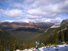
Chris on Cairn and Blustry Mountains:
“It was just Cara and I on an initial exploration of Cairn the Blustry Mountains in the Clear Range. The McGillivray FSR is immediately north of the easily-missed unsigned McGillivray Creek crossing on Hwy 12. The sign is hidden by the cattle gate (unlocked). We followed the directions in the Lillooet hiking guide book (turn left at the 3-km mark, follow the main road to the road end at 9.4 km) encountering 2 other gates along the way. The surface is 2wd but there is some minor rutting and lots of rocks. And there were cows on the road on the way back. The trail is easier to follow up than coming back down (many cow trails leading everywhere). Water is important while hiking in this area and McGillivray Creek seems reliable for at least 2/3 of its length – you lose the better part of the flow near a horse camp. It took us 4 hours to hike to a camp site just beyond the McGillivray headwaters at 2100 m. Water here probably dries up later in June. On the middle day, 8 hours was just enough to traverse Blustry (sometimes on a strong horse trail) and reach the top of Cairn (2300 m) – barely time to sample the vast possibilities of the area. The ridge just to the south of Blustry looks nasty but there is a safe route weaving between the ridge teeth (avoidable by dropping down into Pocock Creek headwaters). By July, this area will be filled with cows and the water will be gone.”
Category Archives: Backpacking
West Coast Trail 09/06/09
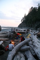
Heather on the West Coast Trail:
“Ribeka K, John A, Bob M, and Heather W did a glorious 9 day backpacking trip along the classic West Coast Trail of Vancouver Island from June 9-17. No wonder this hike is rated as #1 in the world – it is as stunningly gorgeous and amazing as everyone says. Our adventure included hiking pebble beaches, wandering around sandstone benches & cliffs, climbing up and down ladders on slopes in the forest, slipping along muddy trails and broken boardwalks, ambling on sandy beaches, negotiating cable cars, swinging on suspension bridges, and passing lighthouses, caves, arches, and rocky headlands. We marvelled at the many waterfalls, tide pools, whale sightings (four days!), sea stacks, sea otters, martins, bald eagles, sea lions, windswept trees and wildflowers. The trip included great campfires every night, heavy packs, jumping into amazing swimming holes, fantastic company, stupid amounts of food, and intense debates over jelly bean flavours. We were very lucky to have no rain for 8 days, and the fact that it hadn’t rained for almost a month resulted in mud only being up to our ankles instead of over our knees! Other highlights included the milkshakes & burgers in Bamfield, having the local water taxi drop us on a deserted beach for our last night camping, and AMAZING whale watching on the boat that took us back along our whole hiking route to Port Renfrew. If you go, do it before June 15 or after Sept 15, and don’t forget the marshmallows!”
Brandywine Mtn 06/06/09
Chris M. on Brandywine Mountain:
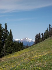
“The 4×4 access road was snow free, unlike the top part of the trail. Glad to have bypassed it. We followed the last branch and quickly entered the meadows. Except for the creek, it is still covered in snow. A collaborative effort in route-finding got us up to the ridge where we set up camp. A site meant for the gods – the views in all directions were fantastic, especially since we seemed to be in a pocket of blue sky. We camped on snow, but rock outcroppings provided a nice place to relax and eat. We went for the peak in the morning with 3 of us reaching the 2213-m summit. Fairly easy scrambling involved. Easy descent and nice drive back to Vancouver by 3 pm. Thanks to Erin, Dorothy and Stacey for making this an excellent experience.”
Skwaha Lake 29/05/09
Chris at Skwaha Lake:
“Snow-free meadows? With ridgetop views? At 1800 m? In May?!? You betcha! Andrew, Cara and Giri joined me on an exploration of the Skwaha Lake area. We approached from the north via 2wd drivable logging roads up Laluwissin Creek and past Onion and Turnip Lakes. There are no trails (except very old cattle routes) so we did a fair share of bushwhacking (some of it was pretty exhausting – hopping from log to log without touching the ground for 50 m at a stretch). The meadows were full of Avalanche Lilies and Shootingstar. Lower down, the Balsamroot was starting to bloom and we found many Chocolate Lilies. And a couple of bears. On the last day, we headed north of the access road and hiked up an unnamed ridge topping out at 2000 m with good views across the Fraser to the mountains of the Stein.”
Cornwall Hills 16/05/09
Chris in the Cornwall Hills:
“Allison, Cara and I ventured into the backcountry west of Ashcroft for a weekend of bushwhacking and bears. Though Hat Creek Road is marked as 4wd on the Backroads Map book, it turned out to be one of the best gravel roads I’ve driven on for at least 11.5 km and the last farm house. After this point, it was still pretty good to where we parked another 2 km along at the fork to Cornwall Hills PP (after this point, both roads are 4wd). We hiked up a draw to a set of aspen meadows that took us almost all the way to Bedard Lake (elevation 1400 m and snow-free). The area is well used by cows starting in June but right now it’s left to the bears (saw 2 black ones and heard about one very large cinnamon or grizzly) and elk. On the middle day, Cara and I bushwhacked to some hillside meadows to the north through undulating pine-kill forest (read: lots of deadfall, few lines of sight and pockets of snow). At 1700 m, there was 2+ feet of soft snow in the trees between meadows making travel slow. The meadows gave good views into Hat Creek Valley, to the Clear and Scarped Ranges and beyond. Excellent navigation skills and tools are required for this area.”
Lower Stein Valley 10/04/09
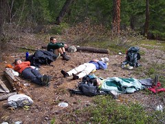
Chris in the Lower Stein Valley:
“Cara, Michele, Norico, Ribeka and I spent 3 days of mixed weather in the Lower Stein valley. Since it’s one of the only early-season overnight destinations within a reasonable drive of Vancouver, it was pretty busy – almost as busy as the May long weekend is traditionally. Teepee camp was packed and both Earl’s and Cable Car had 8-10 tents. We spend two nights at Cable Car and dayhiked to Ponderosa. The trail was snow- and mud- free and there were no blowdowns to speak of. The river was about 4-8 feet below spring levels and river-side snow and ice made water access tricky in places. Nights were cold but above freezing and the days were warm when the sun came out. There’s a dead deer in the river across from Kline’s Cabin so treat your water. We were back at the cars half an hour before the hard rain started and ate Chinese food in Hope while discussing the merits of curry-flavoured bubble bath.”
Phelix Creek 15/11/08
Chris at Phelix Creek:
“Andrew, Cara, Gloria, Lucy, Midori and Ribeka joined me on a rather wet trip up to the Brian Waddington hut in Phelix Creek. The Blackwater Road was in good 2wd condition with minor potholes and a small amount of slick mud. The Phelix Creek Road is rough 2wd for a couple hundred metres before it becomes fully 4wd at the remains of a rock slide – park 2wd vehicles at a sign warning about mudding about 200 m up the road. We all piled into Andrew’s Jeep and drove to the end of the road (almost as fun as the Lone Goat trip). The trail is well marked with reflective orange metal tags and snow patches started early (1200 m). It took almost 3 hrs to hike / slog / snowshoe to the hut (only 4 km). There was up to 2-3 feet of snow in places but the lake was slushy and not yet frozen (1700 m). Temperatures never dropped below freezing even at night and it rained / drizzled almost continuously. The cabin is outfitted with only a small (size of a large pot) portable white gas heater which did little but fill the hut with fumes so it was soon extinguished. The hut was clean and, because the surrounding hills often have high avalanche danger, provided with much reading material (check out the outhouse log book) and many sets of playing cards. By morning about 6″ of snow had melted off and several people headed up the valley for a bit of exploring before we headed back to the trailhead. The hugely variable freezing level makes this time of year tricky to go hiking.”
Lone Goat Cabin 25/10/08
Chris at the Lone Goat Cabin:
“Gloria, Joss, Lucy and I all piled in Andrew’s Jeep for a trip up to the sledder’s cabin in Lone Goat valley. The Hurley was in decent condition with about 2 inches of snow at the pass. The Lone Goat spur leaves the Hurley immediately after the bridge over the Hurley River and is in rough 2wd shape for a little over 1 km after which high clearance 4wd and a complete disregard for your paint job is required (5 foot alders growing out of the centre strip). Andrew enthusiastically threw his vehicle at pretty much everything. Maps show a main road paralleling the river and a road forking off up Lone Goat valley but in reality, the main road has disappeared and you don’t have to make any turns to go up Lone Goat. We parked at around 4 km before the alders really started to crowd the road. A rough winter rough is marked leaving the road near the pulled bridge near the end of the road. There’s a mix of sporadic flagging (yellow, blue, pink, white, etc) but the route regularly breaks down to a pure bushwhack (including alder, boulder fields, wet meadows and avalanche debris). It took 5 hours up (including a bit of confusion in finding the cabin – we walked past it initially). Patchy snow from about halfway up and continuous near the cabin. The cabin itself is outfitted with a good stove and solar electric lighting and benches for sleeping 4 plus floor space for another 3. No thermometer but I’d guess just below freezing in late afternoon to -8 C in the early morning. In the morning, we climbed a 2400-m peak north of the cabin (Andrew and Joss summitted). We encountered snow drifts of up to 3 feet of powder in places but there was plenty of flowing water even at 2100 m. After lunch, the trip back to the car took only 3hrs (probably because we picked a better line).”
Blowdown Cabin 18/10/08
Chris at Blowdown Cabin:
“It was an impromptu reunion of the Halymore-Melvin trip with Cara, Dean and Quirine joining me. The Blowdown Road was sloppier on flat stretches and near the spurs at 1 and 2.5km (you will get muddy) but there are no new waterbars (see trip report for Blowdown-Van Horlick Divide for more on this road). It looks like there hasn’t been any recent snow in the area. At 1600 m, any snow was in sheltered pockets. On south-facing slopes, continuous snow didn’t start until 2200 m or higher. At the cabin (2000 m in a sun-sheltered bowl) there was only 4-6 inches of dry, crusted snow. But temperatures were low – not much above freezing in the early afternoon and -6 C at 7:30 am. The trail to the cabin isn’t flagged well so with the snow covering the upper parts of the route, we frequently lost and regained the trail. The meadows were only partly frozen (i.e. still wet) and there was still flowing water in some places even above 2200 m. Log crossings and boulder fields were either frosty or wet so pretty treacherous. The cabin was, in the words of one log entry, ‘pimped’ and mouse-free. Found out that Dean can bust out some crazy dance skillz. Thanks for a cherry trip, guys.”
Mount Baker Region 11/10/08
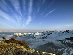
Astrid M. at the Mount Baker region
“The weather Gods were with us this weekend and we enjoyed the rich variety of trails and landscapes in the Mt. Baker-Snoqualmie National Forest. Following the Ranger’s tip, we went to Hannigan Peak on Saturday which is an open trail through a nice valley leading up to the peak with stunning 360 degree views. Snow started at about 1300m but did not pose much of an obstacle. After a cozy night in a cabin we set out to hike the Ptarmigan Ridge on Sunday. The road is closed beyond Heather Meadows where Picture Lake is located which means some extra work to get to Artist Point were the trail starts. The parking lot at Artist Point was already covered in snow. The views from the trail are spectacular with Mt. Baker constantly in view. Some parts of the trail after the junction with the Chain Lakes trail were frozen solid with a thick layer of ice. We did not make it all the way to the Coleman Pinnacle but opted for an earlier return in order to take the Chain Lakes trail back to the parking lot. We were rewarded for that decision with more amazing views of lakes, meadows, alpine landscape and snowy mountains. Thanks a lot to the group for being flexible with making route decision. I believe we all had a great time.”