All posts by andy

Coliseum Mtn 20/09/09

Rob M. on Coliseum Mountain:
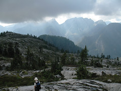
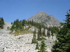
“We first laid rubber an a rolling, museum grade asphalt road, biking towards an underrated jewel on the North Shore, Coliseum Mountain. After this idyllic 9 km, a 1 km Dr. Jekyll and Mr. Logging Road change-up ends at an unmarked but obvious trail. The overtaped Christmas Tree look beginning belies the rugged and unrelenting ascent festooned with small root and rock scrambles through new and old growth hemlock. The trail from the 1000 m Paton Lookout takes you down into a small valley then a grind up through a bolder field and the 1441 m summit of Coliseum. The forces of good prevailed after a dramatic struggle between sun and cloud and we were awash in warm light. Lotsa blueberries along the way and hence one bear encounter, who had better things to do than deal with humans. The Coliseum to Burwell (1521 m) hike is a must-do over a large field of smooth open granite for a modest net elevation gain. We met one intrepid hiker travelling incognito with full pack from Cathedral Mountain. The rangers here are kept busy de-taping The Needles to Cathedral Mountain corridor made by renegade hikers. There are a couple of large, deep R&R tarns before stumbling down the slicker-than-heavily-oiled-banana-peel descent. To take us out of our (dis)comfort zone, Eric led us on an off-trail bushwhack around the summit. The bike ride back was a scream! A full 10-hour day.”

Coliseum Burwell one

Golden Ears 19/09/09

Heather on Golden Ears:
“Bob, John, and Heather did a shorter overnight trip, leaving Saturday afternoon and hiking 5.5 km up to Alder flats to camp. From there, they left the tents Sunday morning and hiked to the peak of Golden Ears, enjoying blueberries and watching the clouds come and go. The peak was clear of clouds with partial views to Pitt Lake and some of the mountains to the north. However, other clouds obstructed Mt. Robie Reid and the Fraser Valley, so the views weren’t quite as stunning as they could be. Unfortunately, the trail was the most littered with garbage of any provincial park that I’ve been in. This included the emergency shelter being a complete mess, and random garbage and graffiti everywhere else. Too bad. Sunday’s total distance, 18.5 km, took us 11 hours with a few nice breaks. A bit of a slog as a hike… I have previously done it in one day by mountain biking 6 km up the east canyon trail, stashing the bikes, crossing the river, and bushwacking up to the main trail, and I think I prefer that strategy to the 24 km slog.”

Tetrahedron 13/09/09

Ahmad on Tetrahedron:
“A big portion of the trail is on an abundant logging road. It is overgrown and it has not been maintained for a long time. I had even doubt that we were following the right way and we took a detour up hoping that we would hit a proper trail. There are many spider webs on the trail. They literally became our trail markers. The trail conditions slightly improves when the steep section starts but this is when we decided to turn back as we were short in time. I estimated we still needed 3 more hours to get to the peak.

Rainy Creek logging road is absolutely rough. I did it before by 2wd car last year but I don’t know how I managed that. Fortunately today, we had a car with high clearance. On the way back, we checked out McNair Creek logging road and it seemed that it was doable by 4×4. I believe this provides a better access point. Another idea is from Mount Steele trailhead.

Our whole trip took 7 hours. I wouldn’t recommend the trail that we did to anyone.”

Central Valley Greenway cycling 12/09/09

Su-Laine cycling the Central Valley Greenway:
“Christine and I cycled the new Central Valley Greenway from Science World to New Westminster. Vancouver and Burnaby were easy and pleasant riding. As others have reported, route signage in Burnaby is not always easy to follow. However, the temporary signs that have been put up are very helpful, and overall the ride was easier than I expected. There are a few steep but fairly short hills heading into New Westminster, and closer to downtown New West the only reasonable option at this time is to ride on the narrow sidewalk and try to ignore the horrible traffic noise next to you. A brief detour to check out Burnaby Lake was a highlight.”

Eaton Peak 12/09/09

Peter A. on Eaton Peak:
“Bahman, Michael, Eric, Thomas, Ben, Irina, Evgeny, and I tackled the tough hike and scramble up Eaton Peak’s west summit. The first 4 km of the trail is a 915 metre climb up to Eaton Lake. The trail was well-marked and generally quite wide. The 3 log “bridges” across Eaton Creek were in good shape, and because it was hot and dry, no problems with the logs being slippery. We reached the beautiful lake in approx 2 hours. From the lake, the route is a bushwhack through forest in a south-east direction to arrive at alpine just below a prominent cliff which can be seen from the lake. To start our bushwhack, we found an obvious trail behind the campsites that led uphill to a small boulder field. Across the boulder field there was a piece of flagging tape. Beyond that point, no tape was visible, and so I led our team to the east on a gradual ascent through very dense trees and bush, not wanting to cut too steeply uphill. The correct direction was to head more directly uphill (south). We eventually found Eaton Creek above the lake, and because the water flow was manageable and the rocks and moss not too slippery, we climbed up the creek to a plateau. We then followed a dry creek bed up a steep gradient and arrived at the prominent cliff face. We traversed below the face, and then climbed a steep boulder field to attain the north edge of the basin in front of Eaton Peak. Access to the west ridge was an obvious notch along the ridge. After crossing the boulder-filled basin, we scrambled up a steep ramp leading to the notch in the ridge. The start of the ridge scramble was very difficult as we crawled and climbed our way through krummholz-overgrown boulders. However, as a result, we avoided the first crux referred to in other trail reports. The second crux (the chimney) was challenging, but fun as the rock is very stable (our experienced alpinist, Bahman, assisted those who needed some suggestions for foot and hand holds. We also fixed a rope for support). Throughout the ridge ascent there were mild to moderately exposed ledges and slabs, and straddling the boulder in the “au cheval” move provided lots of laughs. The summit was beautiful, and our visibility exceptional. Baker and many other notable mountains were clear. Our time from trailhead to summit was approx. 5 hours. On our descent, after carefully down-climbing the chimney crux, we dropped down the steep gully that lies immediately to the west of the ridge and followed this almost to the notch where we had first gained the ridge. Then, during our descent of the boulder fields to the creek, we spotted a black bear feasting on berries. Thankfully, it was on the other side of the fields. We also feasted on huge blueberries and huckleberries. Since the water in the creek was relatively low, we avoided a lot of bushwhacking by descending the creek as far as we could, then bushwhacking west to the campground on Eaton Lake. We left the lake at 7:20pm, and ended up using our headlamps to arrive back at the parking lot. Total time was 11 hours. An outstanding hike with technically challenging scrambles, and a great group!”

Mt Grant 07/09/09

Ahmad on Mt Grant:
“We had to turn back. I had myself no chance to continue. The fresh snow was a formidable barrier that we couldn’t pass through. I didn’t expect it and I was under-prepared for it. It was a good reminder of what frozen feet meant.

Eaton Lake trail was in good condition as it was when I did it 3 months ago. The bridges were still not repaired. The first log was wet and more slippery but doable with good care. The fork to Grant was just after the broken bridge at elevation 1300 m. We followed the south edge of the ridge. There was no trail defined. Some old ribbons and cairns from time to time till we got to altitude 1400 m. The ribbons became abundant in most places. There might be another newer trailhead closer to the third bridge.

The trail is generally bushy before the steep section. I was at the back all the time and I got soaking wet from all the water was on the leaves. The steep slope starts at 1550 m. The rocks were wet, cold, and slippery. We managed to negotiate them till we got to 1850 m.

I believe this hike would be have been a pleasant and quite scenic in good weather. I think the scramble would have been also easy.”

Unnecessary Mountain 01/09/09

Steve on Unnecessary Mountain:
“I didn’t expect such a good response to a mid-week callout. I went with 4 other well matched hikers to Cypress Bowl where we hiked to St. Mark’s Summit, and then on to the dual summits of Mt. Unnecessary. The trail was well marked and easy to follow with 1 minor exception where we got off trail. The weather was variable but we did not get hit with rain. In fact, it was perfect as it kept us cool on the journey, and though it was socked in when we got near the Lions, just as we were leaving, it broke through and offered some moody photo ops.

I really liked this trail, though it was pretty long and the multiple ascents took its toll on my knees. The blueberry factor was phenomenal, and probably added an hour to our trip. One piece of advice I’d offer it to do this as a one way hike and visit the Lions, then descend the Binkert trail. That may actually shave some time, but more importantly allows you to see more peaks on one trip.”

Mt Seymour 30/08/09

Carollyne on Mt Seymour:
“Four of us had a great day on Mt. Seymour. Few cars were in the parking lot when we arrived at 9:45 and the trail up and peaks were quiet – for Seymour on a sunny weekend. There were a few mosquitoes in the shady spots, but no bugs bothered us elsewhere. Haze, perhaps from wildfires, somewhat obscured the views at the top. There was a distinct, if faint, smell of smoke in the air. On the return, the trail was quite busy with people going up. A highlight was watching a black bear feeding on blueberries about 30 minutes up from the parking lot. The trail took 4.5 hours round trip at a fairly leisurely pace plus a very leisurely lunch. We left a now full parking lot and had drinks and appies on Commercial Drive before heading home. Great company made the day even better.”

Mt Bishop 30/08/09

Peter B. on Mt Bishop:
“Three of us biked for one hour along the nice Seymour Valley Trail, waded through Seymour river, climbed up to Mount Bishop for 3 hours (with a 1h stop at Vicar lakes and 1h on the summit) and down for 2 hours and biked back for another hour. The trail is very steep, quite bushy but well-flagged and there is no shortage of ropes. We all liked the upper parts (the lakes and summit) much more than the first 2 hours through the forest. There were many blueberries and blueberry-loaded bear poo. We also saw a bear from a distance (probably eating blueberries or …).”

Williams Peak 30/08/09

Peter A. on Williams Peak:
“Hurrian, Siegfried, Nikita, Alex, Lana, Carol, Dave, Thomas and I successfully climbed the relentlessly steep Williams Ridge in 30 degree heat, braving wasp stings and enjoying a bounty of huckleberries and blueberries. Approx 1000 m elevation gain straight up: like the Grind, but higher and without steps. After another hour of hiking along the beautiful, rolling forested ridge, we ascended “the first knoll” for lunch, which sits across a rocky basin from Williams Peak. The trail from the parking lot to this point was clearly marked and well-maintained. Beyond were various routes for ascending the peak.

After lunch, six of us set off to summit the classically-shaped summit horn: the heat and blisters took their toll on three of our party. We followed Gunn’s route, beginning by descending steeply a lot of vertical into the large basin below the mountain to avoid cliffs. From there it was a long, hot ascending traverse across a number of boulder fields and ridges to reach the base of “the ramp”. Though steep and dusty, the trail up the ramp was clear and contained few loose rocks, providing easy access up and over the south ridge of the peak. A short traverse dropped us into a large, prominent gully that led straight up to the summit. Take time to note where you enter the gulley so you can easily find your exit and route back to the south ridge on your descent. The gully is very steep, but mostly grassy with lots of foot-holds. Since it was hot and dry, it was just a long grunt up: I wouldn’t want to do this up or down when it’s wet and slippery. It took us 1.5 hours to summit from the first knoll.

Views on top were hazy but spectacular. The Peak is surprisingly broad, although the drop-offs are super steep. On our descent, on top of the south ridge, poised to start our way down the ramp, we found a series of cairns leading off to the right. We followed these, which took us on a gentler descending traverse, keeping us higher above the basin and many (but not all) of the boulder fields. Cairns led us just below the cliffs of the second knoll, until we intersected with our original route directly below the first knoll, but much higher above the basin. Our return to the first knoll via this route took a little over 1 hour.

The long, descent to the parking lot was happily broken up by sessions of berry picking and eating. Round trip time was approx. 9 hours. The hike was physically demanding (no water sources from the ridge onwards), but the scrambling was technically easy. A great group and an outstanding hike.”

DSC01860