
Carollyne on Mt Seymour:
“Five of us headed up. The weather: disappointing – low cloud that turned into fog for most of the hike, so no views were to be seen until we were back at the parking lot. The black flies: intense!!! The view of Seymour from Vancouver: deceptive – there’s still a lot of snow up there. By the time you reach First Peak, it is solid snow except for larger rock outcrops such as the peak itself. Another hiker returning from Third Peak reported that from Second to Third is all snow. Due to the weather mostly, we decided First Peak was enough for today. The inspiring conversations and harmonious group (Nuria, Marisa, Holly and Melonie) made for a great hike however, regardless of the conditions.”
Yearly Archives: 2012
Diez Vistas 18/07/12
Carolyn S. on Diez Vistas:
“Five of us (Kim, Jenny, Melonie, Linda and I) set out to Buntzen Lake and the Diez Vistas in Port Moody on July 18. It being a Wednesday and cloudy we had the place nearly to ourselves. It was great to have Kim along as he had done this hike many times before and could direct us. Despite the clouds we had some decent views of Burrard Inlet, Deep Cove and the beginning of Indian Arm. We got in a dip at the north end beach as the sun broke through the clouds. We hiked at a leisurely pace and were back at the parking lot after 6.5 hours. It worked out really well. I encourage others who haven’t tried doing a callout yet to give it a try.”
Brunswick Lake 15/07/12
Andrew L. attempting to get to Brunswick Lake:
“Despite some last-minute bailing and a weather forecast that had turned from favourable to questionable, John and Louise joined me for an attempt at Brunswick Lake from the Porteau Cove trailhead. The logging road from the parking lot up to the trailhead was gated and locked, but a small detour around the gate has been created – if your 4WD can handle the detour, I expect it can handle the road that follows. As we ascended on foot the skies, which had been merely cloudy, grew darker and rumbles of thunder could be heard in the mountains ahead. As the rain began to fall, we found some shelter under the trees and decided to wait and see if the storm would clear as the forecast had suggested. Alas, after twenty minutes the rain merely grew harder, the skies darker, the lightning brighter and the thunder louder. We decided to turn back and almost immediately as we did so the rain increased to a torrent and the lightning struck with what I could only describe as ferocity. It seemed like the mountain was telling us to GTFO. In the end we took a quick trip to Porteau Cove and strolled along the beach before calling it a day.”
Greendrop Lake 15/07/12
Andy G. at Lindeman and Greendrop Lakes:
“Nine of us headed east to visit the turquoise waters of Lindeman and Greendrop Lakes. I’d forgotten how enjoyable this trail was and, although Greendrop Lake itself is a little anticlimactic, especially after passing Lindeman so early in the hike, I really liked the variety along the trail: some places it’s a nice footbed, others it’s boulders. The forest has numerous large trees, and the woodland flowers are beginning to bloom. The cracks of thunder as we crossed the boulder fields in the valley between the lakes added some atmosphere to the day. The trail is flooded just beyond Lindeman Lake, but getting by is straightforward over the large boulders. The creek crossings beyond the lake might be a little daunting for some right now with the high water. Further on, past the turnoff to Flora Lake, the creek takes multiple routes across the forest floor and the marked trail is impassable (unless you don’t mind wading). However, there is an obvious pink-flagged route off to the left that leads to a log crossing over a broken log. I’m not sure how much longer that will survive. Remarkably few mosquitoes – I only got half-a-dozen bites in total. Many thanks to Cara for organizing this hike.”
Saturna Island 13/07/12
Markus on Saturna Island:
“Thunder and lightning greeted us as we reached Saturna Island giving Brenda, Susanne and I a dramatic start to our trip. Fortunately, there was no rain at our campsite at Narvaez Bay as we settled in. Warm sun greeted us the next day as we made our way to East Point Park. On our way we saw plenty of deer, otters, seals, eagles and a pod of killer whales. In the evening we enjoyed a beautiful sunset after dinner and had an early night. The morning was spent relaxing in our tents as we waited out a drizzle and then made our way back to the ferry terminal for lunch at the local pub (note: they have good gluten free burgers). The ferry arrived, bringing with it the sun, and we saw yet another pod of killer whales on the way back.”
Needle Peak 06/07/12
Chris M. on Needle Peak:
“A very enjoyable night on a mountain. Susanna, Glen, Jenn joined me to sleep at 1,947 m, along the summit ridge of Needle. Though a bit hazy, the views were good and the weather warm. Snow starts after about 20 minutes along the trail. There are some rocky outcroppings along the first ridge but mostly snow covered. The summit ridge and both scrambles are completely bare. With overnight bags on, there was one awkward spot on the first scramble, but we worked together as a group and sailed through. Animals stole my liner socks during the night – we couldn’t decide whether the thieves were birds or marmots.”
The Chief 09/06/12
Brenda C. on the Chief:
“Saturday turned out to be a great day for a hike after a cool, rainy week in Vancouver. Doug, April, Sebastien, Hiromi, Sean, Janice and myself left the parking lot around 9:30 am. The trail was wet and muddy at times but there was no snow to slow us down. We reached the third peak in about 2 hours after taking several breaks for pictures and rests along the way. We then made our way down to the second peak, which was busier than the third, enjoyed the view of the mountains peaking through the clouds, ate lunch and rested. The route down was expectedly busy with a serious traffic jam at the ladder and chains section. We made it back to the parking lot after about 4.5 hours. It is definitely a good idea to start this hike earlier in the day to avoid a crowded parking lot and trail.”
Hydraulic Creek 03/06/12
Chris M. at Hydraulic Creek:
“Three of us went for a 5-km bike ride along the non-motorized and paved LSCR. The trail starts right after the bridge. It is easy to follow but Joanna did mention it was quite steep. We reached the ridge junction in 2 hours, spotting our first snow there. Hiking uphill seems to give Adina blisters so we headed back down (she’s hoping for future callouts that are downhill both ways!). The waterfall sounds nice but is hard to get close enough for any good photos or great views. Everyone agreed that cycling back is much better than walking and that this area was very enjoyable.”
Cloudburst Mtn 03/06/12
Eric A. on Cloudburst Mountain:
“Three of us decided to tackle Cloudburst. We decided the best access was from the Chance Creek FSR (turns off the 99 near the turnoff to Garibaldi Lake). Turns out this is definitely the best access, only about 7 km of driving on good open logging roads. Then on foot because the road is washed out about 2 km from the end, and gets really bushy the last 1 km. The route we chose began from the end of the overgrown logging road. We bushwhacked (after avoiding almost all the clearcuts by taking the old logging road) up and kept to the right once into the trees. This unmarked route skirts some cliff bands, and is generally quite steep and direct. We ended up in avalanche debris, and followed it up a valley. This could be a treacherous route if the avalanche hazard is significant. This valley ended up on a few ridges that led to the summit ridge. Unfortunatley it was a whiteout and windy on the peak. Late May – early June is an excellent time to do this hike! Crampons and an ice axe would be nice to have.”

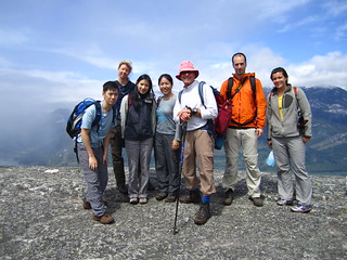
Mt Harvey 26/05/12
Robert D. on Mt Harvey:
“Seven of us (Robert, Ben, Viviane, Shari, Do, Jack & Jeremy) along with dogs Basil and Cedar set out on a fantastic day weather-wise to climb Mt. Harvey. The trail head parking lot was already full by 9 am, luckily we managed to get some spots not too far back down Sunset Drive. Trail was in great condition and the turn-off for Harvey well marked from the Lions trail. Snowline started about 1100 m. The snow in the trees is well packed, somewhat slippy and will take a another few weeks to melt out. The ridge itself was still snowbound and has some small cornices which demand care. The views from the top towards the Lions and beyond were expectedly spectacular. We made it back to the cars in a round trip of about 8 hours. Thanks to the great group for a memorable hike.”