
Robert C. on the Alouette Mountain trail:
“Alouette Mountain is located in Golden Ears Provincial Park near Maple Ridge. On the Friday before the Victoria Day long weekend, seven of us headed out on the trail to Alouette Mountain which provides an endless panoramic view of neighbouring mountains and other landmarks. Without snowshoes, our goal was to hike to the snowline but we were motivated to reach the summit after realizing the snow was relatively easy to walk on. It was a challenge physically, especially to do a hike that is even considered long in the summer (22 km return) with an elevation gain of 1100 m and a peak elevation of 1366 m. This trail has lots of variety winding through forests and an old logging road. This hike was a great example of teamwork as each played a role in navigating as we tried to view the tree markers, some of which were buried under the snow. After about 4.5 hours hiking through the snow we saw the famous Blanshard Needle that towers over the mountain. There are great views of Golden Ears Peak, Edge Peak, Evans Peak, Robie Reid, Alouette Lake, and more. After about an hour on the peak, we headed back down to reach the trail head 2.5 hours later. I would recommend this trail to anyone who likes to snowshoe in the spring, and also to those who like beautiful views from the summit.”
Cheakamus Canyon 09/05/09
Susie at Cheakamus Canyon:
“Susie, Angela, Louise and Noman met on a gorgeous Saturday morning for this very enjoyable hike. With Highway 99 open through the contentious Eagle Bluffs, travel to Squamish is now fast and easy. We drove to the end of the road in Paradise Valley (we had a 4×4, but saw 4x2s at the parking spot), and started up the trail to cross the BC Rail line. That dealt with most of the (minimal) elevation gain, and soon we were at Starvation Lake, very pretty on a sunny morning with a couple of Canada geese posing in the middle. Shortly after we entered the canyon area, via an exciting piece of trail where you are literally walking on air … fortunately over some sturdy netting securely fastened to the cliff. The sound of the Cheakamus River pounding through the canyon was with us for the rest of our trip. It is impressive looking down at the railway line below and marvelling at the engineering required to build it. The trail must pass through a rain shadow, because the vegetation is more reminiscent of the Interior than coastal rain forest. The trail eventually peters out at Highway 99, so we turned around before the traffic noise was too great. A lovely relaxing hike, although we agreed it probably should be classified as a “wike” (walk/hike). It’s worth noting that this trail is snow free 99% of the year.”
Levette Lake 09/05/09
Chris on the Skyline and Copperbush Trails near Levette Lake:
“Cara, Ivy, Jennifer, Susan, and Tao joined me on a leisurely ramble around the Skyline/Copperbush trails with a sidetrip to Levette Lake. Don’t believe the bad reports for this trail that you might read on the Internet. Granted, if you plan on going in a clockwise direction, the start of the trail is tricky to find and looks a bit overgrown but it’s fine after 100 m – just watch for the painted can lids nailed to trees. The lookouts have grown in a bit (like at Diez Vistas) but the views are still great (Tantalus in your face) and the trail is quiet. Levette Lake is popular and we encountered a large car-camping group up there. Hanging out at the lake is a bit cooler than at the bluffs (like Silver Summit) to the south.”
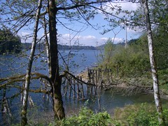
Hayward Lake 09/05/09
Paula on the Hayward Lake trail:
“We couldn’t have wished for better weather for this hike. The group of eight were ready to embrace the day with good cheer. Initially missing the turnoff to get us on to Dewdney Trunk Road, we soon realised our mistake, it added extra travel time to reach the trail head but otherwise would be less than an hour from our meeting place at Safeway at Broadway & Commercial.
It is a well marked and maintained trail, much like Buntzen Lake but almost twice the distance. The old railway trestle bridges half emerged in the water provide an interesting backdrop for photographs as does the forest with moss covered trees, ferns etc. The Steelhead Falls was spectacular this time of year, running fast and furious, we stopped to take photos and snack at the base. Whilst we did pass a few small groups of hikers in the afternoon, it was relatively quiet on the trail. Back where we started we relaxed in the sun and contemplated taking a swim from the sandy beach.
Whilst there is not a lot of elevation the upsy/downsy trail and the 16/17 km length does provide a good workout and trail time was 4.5 hrs including our rest stops.”
Upper Shannon Falls 09/05/09
Su-Laine at Upper Shannon Falls:
“Upper Shannon Falls is an underrated trail in two respects. Where else, at 12:30 PM on a gorgeous Saturday, can you have an entire summit to yourself with beautiful views over Howe Sound? Other than the 185 m of staircase that it shares with the Stawamus Chief trail, this hike is uncrowded enough that you can feel that you’re getting away from it all. The trail is also underrated, though, in terms of difficulty. Don’t be fooled by the fact that it’s listed in a book called “109 Walks” or by memories of family picnics in the lower Shannon Falls area – on average this trail is about as steep as The Lions.
Our planned Cheakamus Lake trip didn’t happen. We got about 3 km into the 8.5 km logging road off Hwy 99 and had to turn back because of snow on the road. Vehicles with high clearance might be able to get to the trailhead, but I’m not sure. A stroll in Whistler after dinner took its place as our second hike of the day.”

Campbell Lake 09/05/09
Michelle on the Campbell Lake trail:
“Think hiking in Chilliwack is closer to home than the Harrison Hotsprings area? Think again! This ‘think outside the Vancouver bubble’ hike proved to us that although Chilliwack is before Agassiz and Harrison on the highway, in actual fact it took us only about an hour to reach our destination, far far FAR less than reaching many popular Chilliwack trailheads. Why? Easy to navigate quick to drive highway all the way to your destination vs never ending are-we-there-yet Chilliwack Lake Rd and service roads which turn your Chilliwack turn off of Hwy 1 into just the ‘beginning’ of your trek. However, note that upon our arrival the lovely map at the trailhead was covered with a “TRAIL ACCESS CLOSED” sign. Thanks to April for taking on the wild goose chase of tracking down details. According to Public Works, trail access is scheduled to re-open by beginning of October. However, alternate access to Campbell Lake and trail is provided via the Mount Woodside service road with a 4×4, which also passes by Stacey Lake. The area was clear of snow and the views from the outlook were the highlight. Exercise extreme caution if in the area close to the #9 (Hot Springs Rd) trailhead – apparently they are doing some periodic blasting work. Public Works Inquiries 604-796-2171.”
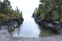
East Sooke Trail 03/05/09
Erez on the East Sooke Trail:
“On a cloudy Sunday, Phil, Iris and I took the Ferry to Vancouver Island, drove past Victoria to East Sooke to the Aylard Farm trailhead of the East Sooke coast trail. The entire trail is about 11 km, but since we had only one car we hiked only to Cabin Point, taking the interior trail back to Aylard Farm. It took us about 1.5 hours to reach Beech head (a bluff overlooking the ocean), and another 1.5 hours or so to get to Cabin Point. The interior trail from there back to Aylard Farm turned out to be rather short and after an hour we were back in the car. Although it does not have any serious elevation gain the trail is not level and goes up and down quite often. The scenery was great – thin forest, green meadows, lots of Arbutus trees, emerald-coloured ocean, little coves, all made the trail quite interesting to walk on. We saw a woodpecker, a couple of eagles, and interrupted a sleeping seal at Cabin Point. There were very few people hiking the trail with us. Our only regret was not to have two cars so we could have hiked the entire trail. Oh well, next time.”
Shannon Falls and the Chief 03/05/09
Heather at Upper Shannon Falls and the Chief:
“Nine of us outwitted the weather report and had a great day doing a double hike to upper Shannon Falls and then the 2nd and 3rd summit of the Stawamus Chief in Squamish. The group included a nice mix – from “first hike in Canada” to our local “Mountain Meister”, plus three other Wanderungers that we bumped into along the way. After all these years, I’d forgotten how steep the Chief is, but we all got a good workout and took extended lunch breaks on the bluffs overlooking Howe Sound and then on the second peak while watching the cute chipmunks running around. The chains and ladders between 1st and 2nd summit add excitement to the way up, and the loop trail between 2nd and 3rd summits is an easier, varied way of getting down. All of us enjoyed a good early season hike and great company.”
Cloudburst Mtn 02/05/09
Ahmad on Cloudburst Mountain:
“Dan, Trevor, Tamsyn, and I summited after six hours of hiking. The trip started by a maze of logging roads. We found the right one fairly soon after two trial-and-errors. I parked just before the snow line which was at 600 m altitude and 3.2 km from start of the logging road. We walked along the road which ends at 7 km. No marker after that. The next stage was to find a reasonable opening in steep rocky slopes which perhaps was the hardest part of our hike. Once we got to altitude 1200 m snow quality improved, slopes ranged from gentle to steep (but not too steep), and it was fun to snowshoe. There is only one short very steep section to gain the summit ridge. Route finding was essential. On the way back, We slid almost 400 m of elevation. It took us 4 hours to get back to the car.”
Mt Gardner 26/04/09
Heather on Mt Gardner:
“Nine of us ventured over to Bowen Island climb Mt. Gardner on a gloriously sunny, clear day. We picked a slightly longer route – taking the trails through Crippen Regional Park from the ferry to the trailhead. We did a circular route, on the way up we branched off the main trail to circle around the east & north side of Mt. Gardner, then came back down past the south summit back to the main trail. There are some nice views to the North from a few bluffs, and then a steep section to climb up to the North Summit. We passed a few tiny patches of snow, but almost all trails are now clear. All trails on this hike tend to be confusing, but the group managed to follow this route by combining people’s experience from previous hikes, a trail description from 103 Hikes, and a little back-tracking! The views from the top were beautiful, even though you have to circle around a bunch of radio towers and other structures – and the helicopter landing pads are great for stretching out and soaking up the sun! It was definitely busy up there – probably 40 hikers enjoying this classic early season hike. As always, this hike was also fun for the great company – from a number of first-time Wanderungers, to our ultra-marathon runner just back from Antarctica, we always had some interesting conversation going on!”