Hanes Valley 23/08/09

Andy in Hanes Valley:
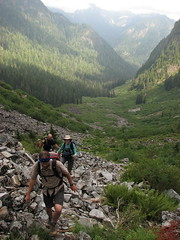
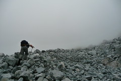
“This has been on my to-do list for some time so it was great to collect a group of six and see the valley up close. We began in Lynn Headwaters and ended on Grouse Mountain. Beyond Norvan Falls (where the creek was just a trickle) the forest soon changed from devastated second growth to a much nicer unlogged forest, complete with some fabulous bright orange fungi. Crossing Lynn Creek was easy on the biggest logjam I’ve ever seen. We broke out of the trees at the helipad where we stopped for lunch before making our way up through the boulder field. The sheer cliffs of Goat and Crown Mountain were quite spectacular and the open nature of the boulder field made for rewarding rest stops with views back to Coliseum and Burwell. We contemplated tackling one of the nearby summits, but unfortunately (or fortunately depending on your point of view), the clouds hung around the summits of Goat and Crown mountains which dissuaded us from adding more elevation gain. So up the muck-and-chains bit we went to join the Goat Mountain trail, and were back at the gondola less than an hour later, pausing only to sample a few of the local berries. To our surprise we had no more than a 10-minute wait for the gondola ride down. The trip took 7 hours end to end. A great day out – thanks everyone!”

Hanes Valley, 23 Aug 2009

Mt McGuire 23/08/09

Su-Laine on Mt McGuire:
“New hiking objective for 2010: finish Mount McGuire. We didn’t make it to the top, but the northwest ridge approach that people have been discussing on Clubtread this year is definitely doable as a day hike from Vancouver. It’s a beautiful area.

Getting to the trailhead from King George station in Surrey took an uneventful 2 hours via the Tamihi Creek FSR. There are reports of locked gates and fallen trees on the road, but we didn’t see any. We were in an SUV and the only other vehicle in the parking area was a Delica. Wide trucks might not be able to get past a couple of rocks on the road. The road is better than the one to Cheam, but I doubt 2WD vehicles could make it up there.

In a routefinding error out of the “don’t ask how we managed to screw that one up” department, we climbed the rockslide on the left rather than the right near the beginning of the hike, in spite of the printed instructions we were carrying and some flagging tape. After 45 minutes of some of the toughest scrambling I’ve ever done, we figured out that it was wrong and downclimbed. The rest of the hike was straightforward by comparison, but there were a few scrambles up steep slopes, and we spent quite a bit of time figuring out where the trail and turning points were. The route mostly follows a mountain goat trail, and is very obvious in some places but not others.

I was wearing a helmet, long pants/sleeves, and bicycle gloves and was glad to have all of them, especially gloves because the rocks that you have to scramble over feel like sandpaper.

We reached a meadow in which you descend into a valley before going up to the summit. Views were good from there and we realized that we weren’t going to be able to get anywhere more interesting by our turnaround time, so we relaxed and feasted on wild blueberries before exploring the ridge a bit more and heading back. It was a very fun day, and we’re all more experienced navigators now. I’d be happy to go back.”

Chain Lakes Loop 22/08/09

Susan C. on the Chain Lakes Loop near Mt Baker:
“Border traffic at the Sumas crossing was minimal; and once across, it is straightforward driving to the Baker National Park. We couldn’t have chosen a better day to head down to the Mount Baker area. The temperature stayed in the low 20s, so the hike was cool and comfortable and almost totally bug-free. The trail lived up to its name – it really is a “chain” of lakes. We started at the lower end of the loop near Bagley Lake and by the end of the hike had lost count of the number of lakes. Suffice to say, it was well worth the drive down. We caught various aspects of Mount Baker, many of which were positively stunning. By the time, we neared the upper end at Artist Point, the trail was starting to feel like the Grouse Grind. Getting on from the less popular starting point, we had avoided the crowds for most of the way.

At less than 500 m in elevation, the hike was not especially challenging but was perfect for a bunch of keen photographers not too worried about breaking any records. The loop (11 km) plus a 3.5 km descent on the Wild Goose Trail back to the parking lot at Bagley Lake took just over five hours. This distance does not include our detour down to one of the lakes for very pleasant lunch break.

On the way home, we stopped at the Mount Baker Vineyards for a sampling which cost us each US $5. The wines were mediocre but it was, nevertheless, a pleasant little side trip. And you get to keep your sampling glass as a souvenir! After that, back across the border for burgers at the White Spot. Again, border traffic was light at around 6 pm. All in all, a most enjoyable day with great company.”

Russet Lake 22/08/09

Jennifer exploring the area around Russet Lake:
“Peter, Laura, Sandi, Michael and Jen all got an alpine start to backpack in to Russet Lake for three days. Via the valley we made our way up Cowboy Pass and down to the lake to set up camp. After a second lunch, we headed up Fissile Peak. Fissile was challenging. There were lots of loose crumbly rocks covered with gravel and quite a long stretch requiring good handholds (of which there were none) giving us a run for our money. We did make it to the top, using the first route described in the Scrambles Guide. The group slipped-n-slid back down the way we came, with a few bruises and scrapes (that shale is full of fossils but also quite sharp!) but no major mishaps. I would recommend helmets for sure (easy to knock rocks down, and we had some narrow misses). Day two followed a crystal clear night of stars. Clouds and some sun made our scramble up Whirlwind peak and on to Overlord Mountain more dramatic. Scampering onto the ridge was the only challenging part of Whirlwind which was otherwise a lot of up with spectacular views of Garibaldi and the Tantalus Range. Now that we’ve done it, we would recommend climbing up the middle moraine to get to the ridge. From Whirlwind we took the northern ridge up Refuse Peak to Overlord. The panorama of peaks and ice-fields filled our eyes and took our breath away. With a couple of exposed areas requiring some careful hand and foot moves, the route up was straight-forward. Back the same way over Whirlwind to avoid glacier travel brought us safely (albeit hungry) back to Russet Lake. We woke up frost-covered in the morning but the sun soon warmed us up (it’s toque, long john, and down vest weather already). Third day was a mellow sunny meander over the Musical Bumps to the lovely gondola which whisked us back to our cars. Potluck dinners and lots of laughs made an unbelievable setting that much better – thanks for a great trip!”

Hanes Valley 15/08/09

Michelle in Hanes Valley and on Crown Mountain:
“All this one mustered was a three-some, which turned into a two-some. John and I had an extended but very enjoyable day completing the full circuit of essentially Lynn Headwaters to Norvan Falls, Hanes Valley, Crown, back to Grouse via Little Goat Pass and Goat Mtn trail. From the PACKED Grind parking lot (packed BEFORE 8am!?) we shuttled to Lynn Headwaters, entering a cloud of fog that we hiked through Hanes. Good thing this quiet valley is truly well marked- little decorated cairns wrapped in glowing florescent orange flagging guided us as we hiked literally from marker to marker in pure faith through the mist in the boulder field (though the GPS agreed). Perhaps not being able to see where we were going or back behind us helped our mental disposition as the elevation gain was seemingly painless. Crown was a little more challenging – especially when you do a bunch of extra wet scrambling/searching at the base when you don’t have to (if everything is mist- follow the orange flagging and red/white bulls-eye paint markers CLOSELY by the beginning of the rock base/forest edge, skirting AROUND on a sideways approach for some time. The final scramble up the summit is minimal. But save some gusto for the stiff climb back out of Crown Pass to Little Goat Pass. I wouldn’t want to do any part of this circuit any wetter than we did on account of what nasty business it would be (too slippery!). Uncrowded valley, “mist”-ical pictures, lovely views atop, tram down, ahhhhh.”

08/15/09 :: Hanes Valley/Crown Mtn

Black Tusk 15/08/09

Pablo at Black Tusk:
“Four of us headed to Garibaldi Provincial Park to hike Black Tusk. We had a very good pace. According to BC parks it takes 8.5 hrs one way to the viewpoint. It took us 8 hours round trip to the chimney including breaks and going back trough Garibaldi Lake. The trail is snow free. The sky was cloudy so some times the visibility was reduced. It was a little bit cold at the top. No mosquitoes at all.”

Macdonald Peak 02/08/09

Peter on Macdonald Peak:
“Irina, Evgeny, Henry, Laura, Jen, Nikita, Carolyne, Neil, Ben, Behrouz, Dan and I braved the heat, sun, bugs, stinging nettles, dead fall on the trail and various other challenges to accomplish a variety of personal goals. The removal of a bridge across the Chilliwack River at the original Radium Lake trailhead means we had to start 2 km upstream in the Chilliwack Lake Provincial Park, and back track along the Centennial Trail to the junction with the trail. We set out at 10:20am, and set a good pace, climbing steadily to Radium Lake. After a feed and watering, we headed up the classic-looking col between Macdonald Peak and Mt. Webb. The trail from the parking lot to the col is well-marked, but because of recent dead fall in a lot of the upper sections, a little tricky to find and slow-going in some areas. There is a suspension bridge across Radium Creek for the first crossing: it needs repair so caution is in order. Close to the lake there is a beautiful undulating Hemlock forest to enjoy, and two patches of stinging nettles and bugs to hate. The last push up the col is steep with almost no shade: hot and brutal. From the col, most of us summited Macdonald Peak (Nikita and Jen fit in Mt. Webb as well!). The route to the Peak is sufficiently marked with cairns and tape. Scrambling is moderate, with some fun big boulders at the end. Huge granite slabs and excellent views on top. Fires on the forested mountain one valley over meant we had helicopters scooping up water from Radium Lake, landing at the col, and giving us a celebratory fly over when we were on the Peak. After a long and tiring descent, the main group got back to the parking lot at 9:30pm. Plan on 5-6 hours to the summit, and 4-5 hours down. Bring headlamps. A challenging and rewarding hike. Terrific group!”

Slim-Nichols divide 02/08/09

Chris on the Slim-Nichols Divide:
“Well, that was an adventure! The usual route to the Chilcoten is over the Hurley but it was closed due to the Coppertop and Camel’s Back fires 2 days before we were to leave. The obvious alternate route is through Lillooet but the McLean fire was within 1km of town limits with evacuation imminent. So Cara, Lucy and I chose to drive over the Highline from D’arcy to Seton Portage and then over Mission Mountain to Highway 40 (this was just before the Seton, Spider Creek and Hell Creek fires were started / discovered). The Highline was not bad. The hill out of D’arcy might be too steep for some 2wd but there was a Ford Focus parked halfway along. The crux is a steepish hill with some loose rock about halfway along – timid drivers need not apply. Mission Mountain is even better – 2wd friendly but you have to like switchbacks (a lot). From Pemberton to Highway 40 was 2 h 10 min for us. Then it was on to Slim Creek road – probably in better shape than last year (2wd with some rough / rutted spots). The long drive and high water levels on Slim Creek changed our plans for day 1 and we decided to camp just before the meadows and cross over early on day 2. We managed to find the trail up the southern branch of Slim but lost it again. We camped in the high alpine near Slim Lakes and could see a couple of smoke plumes in the far east. The wind changed direction during the next night and the whole of day 3 – crossing over Sorcerer ridge and into the Nichols drainage – was smoky. Rain moved in that evening and was on and off until late morning of the next day when we climbed Glacierview Peak. Day 5 was mostly clear as we climbed into the top of the Nichols drainage, touched the edge of Griswold, dropped into Gun Valley and climbed back out over Wolverine Pass to Leckie Lake. Day 6 was very hazy with smoke as we returned to the car. In general, the area was very dry with most non-glacier-fed creeks having dried up and ponds at low levels. Despite some signs of large mammals, we saw only marmots and smaller animals. The real adventure started when we drove back to Gold Bridge to find all access out of the community closed. We ate supper at the hotel and found a campground that wasn’t closed for the night. The next day we hit up the gas station, library, store and hotel looking for information on whether there would be a scheduled convoy leaving for Lillooet (there had been one on the previous day). While we waited, we ran into a couple members of a Land Cruiser club returning from a 2-week expedition into the Chilcotin (we had seen them on our previous trip from a distant vantage point on Battlement Ridge as they climbed the old mining roads on Pallisade Bluff). These guys are serious offroaders with stories of crossing 1 metre deep creeks and carrying spare axles! While we were at the hotel, word came that the Hurley was reopening and there was a mad dash for vehicles and we were off up the Hurley before conditions changed again. We finally arrived in Vancouver 20 hours later than planned.”

Heather Trail / Nicomen Lake 01/08/09

Michelle on the Heather Trail to Nicomen Lake:
“Day 1: 1 French, 1 Israeli, 1 Swiss, 2 Polish, 1 Chinese/Californian, 2 BC Girls, 199km 3hrs driving, 1hr to car shuttle, 36 quarters to park, 13.5km 5hrs Blackwall to Kicking Horse. Side shows: motorcycle dog in his own coach with hush puppy ears a-flapping behind his own windshield (missing sunglasses); Bruno’s purse; new forest fire across a valley from us with helicopters water bombing and planes surveying; startled skinny dippers caught by the bottom of the First Brother; watching 10 cloves of garlic being lovingly minced for a 3 course dinner. Day 2: 9-km 4-hour side trip to the Three Brothers, then 9 km / 5 hours from Kicking Horse to Nicomen Lake. Side shows: GQ modelling at the summit of the Brothers (working the pole); sleeping bag rolling down the hill; Polish Kisiel ectoplasm dessert. Day 3: 17- km 6-8hrs Nicomen Lake to Cayuse Flats. Side shows: morning opera and water football. Casualties: 1 elephantiasis knee, 1 twisted ankle. Summary: Super well maintained/marked trails, beautiful flowers/meadows, splendid views, awesome lakeside camp (with amaaazing swimming and fishing), lots of laughs, lots of food, lots of French, lots of amoré, fabulous people, fabulous trip.”

Marriott Meadows 01/08/09

Su-Laine at Marriott Meadows:
“Definitely a place to go back to… when it’s less buggy. On the other hand, if you like to jump into pristine mountain lakes on hot summer days, it would be hard to beat this place. Some of us swam in five lakes over three days, and we passed by several more.

Forest fires were on everyone’s mind but we made a conscious decision to go anyway, as we felt that this area would not be very dry, conducive to spreading fire, or particularly remote. A thunderstorm arrived quite suddenly in the hot afternoon, and we spent some time hunkered down in the forest to wait for it to pass. We sat on our packs while Michal explained how to perform CPR in case someone got struck by lightning, and I shared the previous night’s reading about how to survive a forest fire (Google it). The bugs were an inferno at the start of the trail and became merely horrible by the time we arrived at the Wendy Thompson Memorial Hut. We’d brought tents, but there was only one other nice couple at the hut, and lots of room.

On Sunday morning we spent the better part of an hour trying to find a trail to the ridge and summit. Several trails leave the hut but seem to vanish, and I don’t know to what extent we should have been on-trail higher up. We eventually found our way to an upper lake using a route resembling what’s in Matt Gunn’s Scrambles book. That was just the start of a stunning array of small lakes in the Marriott Basin, set amongst meadows, boulder fields, and 360 degree views of surrounding peaks. Scrambling was not too difficult, but helmets would have been a good idea. We spent many happy hours exploring, and returned to the hut very tired.

The next day we packed up, cleaned the hut, and swam in yet another lake down the trail before returning to the Marriott-Rohr junction and climbing up the muddy and buggy-as-hell trail to beautiful Rohr Lake. In total we saw only 7 other people in 3 days, and when we returned to Pemberton we heard that access to Duffey Lake Road was being restricted because of the fire situation. I haven’t seen anything on the web to confirm this, but if you’re planning a trip up there soon, a few phone calls to check would be a good idea.”