Tag Archives: Squamish

Pinecone Lake, 4 May 2013

Chris M. in the Pinecone Lake area:
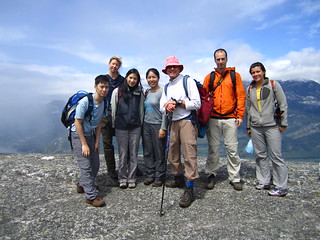
“With the promise of hot sunny weather, 6 of us drove in from Squamish along the Mamquam FSR. Sadly, the snow was lingering lower down than I had hoped. This meant we had to hike 6 km instead of 3 km to the end of the logging road. We had lunch then carried on. The sun had been killing us so a shady break in the trees was most welcome. Never worried about finding a trail as you just need to stay in the centre of the ridge and head upwards. Just before we reached the top of Peak 5700 the day-trippers reached their turnaround time and headed back down. Well, Danielle and Tom did. Jack couldn’t bear to leave the views that were beginning to reveal themselves and he stayed with us.

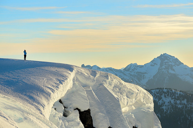
Kicked steps up the last steep parts and Jack had made a wise choice – gorgeous views in every direction! We chose our camp spots and relaxed. Then we soaked in a stunning sunset and relaxed some more. Very little wind, warm temps & great company made this a wonderful night. Gary and Tu Loan had brought tents. I just slept on a pad looking up at the stars. (Having no overnight gear Jack had gone back down to sleep in my car – extra blanket & pillow there.) Waking up and seeing the surrounding mountains again was awesome. The walk back down was simple and just under 3 hours to my vehicle. Be warned, the road isn’t that rough but your car will get scratches towards the end.”

Frozen Hiker

Mt Mulligan, 21 Apr 2013

Chris M. on Mt Mulligan:
“Danielle joined me for a last-minute walk up both peaks of Mount Mulligan. We left Vancouver just after noon. The snow continues to melt and the logging road is now driveable to around 700 m elevation. Snowshoes went on right away and we were atop the North Summit in about 2 hours. It was a bit steep between the two peaks but we arrived there one hour later. So many mountains in all directions were visible from the South summit. My snowshoe snapped near the summit but just boots actually made the descent back to the col easier. Along with some fun bum-sliding. On the flatter terrain Danielle was a hero for trading snowshoes with me as I was sinking deeper. Even after lingering on the summit we still made it back to the car without the need for headlamps. Dinner at the Watershed was a nice way to end the day.”

Sigurd Peak, 20 Apr 2013

Pardeep on Sigurd Peak:
“For a tougher trip I was quite surprised that I was able to get five of my buddies to wake up at 5:00am for a hike. Bala ‘The Baritone Baller’ Kumar, Oudi ‘Owly’ Cherfi, Mark ‘MC Pirogi’ Bondyra, Mark ‘Dragonfly’ Jenkins, Ross ‘Ramblin’ Rose’ Polutnik, and myself P. Diddy Montaigne’ made good on our collective word to reach the summit of Sigurd Peak or Station Rose as others may know it as.

The trailhead can easily be reached with 2WD vehicle; for driving directions visit the Club Tread page for Sigurd Peak, https://www.clubtread.com/routes/Route.aspx?Route=1121. The trail initially starts out along an old road bed, but quickly it veers right off into the forest. The trees that I saw during this were awesomely huge and beautiful! If the late great Randy Stoltmann’s name is associated with an area, you can expect to view some majestic cedars.

The trail is for the most part quite steep; think of doing the Grouse Grind for about nine hours; there is no gondola! I love steep slopes, they’re something so cathartic of pushing yourself physically through an old growth forest and seeing views of the Squamish River Valley and Ossa/Pelion Mountains.

At about 1170 m elevation, the route pushes North around a bluff section, before curling back East, and then heading up the main East running ridge system. Three of the group followed that route, while three went South and then East. I was with the group that went South; it was an interesting choice. We quickly had to start veggie belaying, and eventually were cliffed out. I would recommend not going this way, haha.

The East Ridge itself is quite broad and has great views in all directions; that’s if you’re not socked in. Though the clouds pushed in and out sporadically, that which I did see was superb! The final section of the summit ridge was heavily corniced. I would suggest just sticking to the middle and avoid any complications may arise from travelling too far to the edge of the ridge.

For a group of six young opinionated males, we worked well as a collective. I really enjoyed this trip with my friends, and would like to thank them all for coming along! The next trip? Tzsil Mountain near Joffre Lakes, or something in central Cheam Range.”

Upper Shannon Falls, 29 Mar 2013

Stephen H. at Upper Shannon Falls:
“Ivy, John, and Rasham joined me for a pleasant hike of the Upper Shannon Falls Trail on Good Friday. We started early to beat the crowds, which we ran into on the way down the Chief trail. There was no snow on the route. We enjoyed a long lunch and great views from the final bluff.”

Upper Shannon Falls 18/11/12

Chris M. at Upper Shannon Falls:
“A little rain didn’t stop the 5 of us from having an enjoyable walk to Upper Shannon Falls. It was much less busy than normal on the stairs up towards the Chief. Colleen proved to be an effective shepherd. The bridge across Olesen Creek needs some repairs. On the way back, Daniel fell through but managed to climb back out. Chris mentioned he liked the variety of terrain along this trail. After checking out waterfalls and taking in the viewpoint above, round-trip was around 4 hours. Ellie and the rest of us chatted most of the way making the time pass quickly.”

Hole in the bridge

Petgill Lake 06/08/12

Steve at Petgill Lake:
“This trip brought me back to the early days of Wanderung. I truly enjoyed the company of my seven companions (interesting in the “good way”) as we hiked up to the this classic “two-payoff” hike. I had forgotten how the trail itself is a great part of this hike as we rose and fell through mossy sparsely-treed areas, but payoff #1 was even more of a hit: the lake. Non-glacial temperatures make this one of the best hike lakes I know (six of us swam). After the lake we went up to the viewpoint and had lunch overlooking Howe Sound. On the way down we came across more people than I recall Petgill ever having, including a guided group! (At Petgill?!) On the way down we hit a viewpoint we missed on the way up (around 1/2 way down), that had yet another great view of the Chief and Squamish from a rarely seen angle.

For those looking for a pace to hit on a warm day – Petgill is it. Tons of tree cover for shade, an awesome lake and a viewpoint where you can dry out.”

The Chief 09/06/12

Brenda C. on the Chief:
“Saturday turned out to be a great day for a hike after a cool, rainy week in Vancouver. Doug, April, Sebastien, Hiromi, Sean, Janice and myself left the parking lot around 9:30 am. The trail was wet and muddy at times but there was no snow to slow us down. We reached the third peak in about 2 hours after taking several breaks for pictures and rests along the way. We then made our way down to the second peak, which was busier than the third, enjoyed the view of the mountains peaking through the clouds, ate lunch and rested. The route down was expectedly busy with a serious traffic jam at the ladder and chains section. We made it back to the parking lot after about 4.5 hours. It is definitely a good idea to start this hike earlier in the day to avoid a crowded parking lot and trail.”

Stawamus Chief 09/06/2012

Cheakamus Canyon 28/04/12

Melanie in Cheakamus Canyon:
“The highlights of this trip were: great company and conversation, good weather, views of the canyon, Markus trying to season the train tracks, Donna enjoying her beer, and Ahmad running the first Livetrails app test. The road was not in very good shape and we had to park the car just past the y-junction and walk for the remainder of the road. This last minute call-out filled up very quickly and there seems to be lots of demand for more hikes and organizers!”

Slhaney 11/02/12

Stephen H. on Slhaney:
“Allan, Andrew, Douglas, and Mark joined me for this hike in Squamish. We headed up the Stawamus Chief trail and kept going to the snowy top of Slhaney. Along the way, we ended up taking the older, eroded, more interesting branch of the trail, which has two excellent viewpoints offering a look back to the Chief. The last bit is a rough and steep route. With snow and fog on top, we couldn’t figure out which bump was the actual summit. All in all, the hike was worth all the effort. Good conditions, with snow only really at the top.”

Tricouni Peak 07/08/11

Chris M. on Tricouni Peak
“Six of us went up to Tricouni Peak. The final part of the road was rough on our two 4wds. Trail was certainly muddy to start but we were soon on snow from before the first lake. All us of then went fairly straight up the somewhat steep snow slopes. Erica, Ian & his dog waited near the sub-summit while the four of us – Glenn, Brad, Scott and myself – went up on the top. Bluebird day. The much-sliding down might have been the highlight!”