Category Archives: Day hike

Phyllis Creek 30/08/08

Steve at Phyllis Creek:
“No bugs, no bears, no real reason to go back to this one. There were 3 highlights to this trip: the people, the after-hike dinner at Pondok, … and putting the checkmark in my book. Most of the time on this hike was spent wondering if we were on the real trail. Following orange tape can be problematic when at the highway there were 3 spots marked with orange tape. Most of this trip was a logging road, and the true low light was the slippery log section through prickle bushes (though it did explain why Brian Grover quoted such a long hike time). I wouldn’t recommend this especially because though it ends a 2 little lakes, we couldn’t find a way to get near them and no beach was evident at all (we ate lunch looking down over them). Did I mention the powerlines?”

Thimble berry

Hayward Lake 24/08/08

Anne at Hayward Lake:
“Four of us met on an already rainy Sunday morning in Vancouver. We decided that driving all the way to Chilliwack just to find the same rainy conditions there wasn’t probably worth the effort – so we followed Dave’s suggestions to go to Hayward Lake Reservoir in Mission. It’s a 16km hike around the reservoir, half of it gently rolls up and down through the forest; the other half is a flat open railway trail. The trail also passes by the dam, Dave pointed out that sometimes they offer tours there. We actually managed to start with no rain – unfortunately it did not last for long. The rain set in pretty soon and once we left the the forest covered part of the trail we got soaked pretty quickly; at this point it had turned into pouring rain… By the time we got back to the car, it was with and without GoreTex just dripping down on us… Nevertheless we all got a good workout and fresh air (and the proof that we are waterproof hikers!)”

BCMC Trail 23/08/08

Michelle on the BCMC/Larsen trail:
“What a zooo! Grouse was pretty much the busiest any of us had seen. The parking issues a number of us encountered should have given us a hint at the line up we would have to face for the tram down. A few opted to endure pounding the Grind down in reverse rather than standing there helpless in the mile long line. And one actually beat us down! Thankfully the trail itself was quiet and peaceful.”

Tricouni Peak 23/08/08

Ahmad on Tricouni Peak:
“Perhaps the hardest part of the hike is the 10-11 km logging road to the trail head. It is a rough road and there is a little chance that a small car can reach 8 km as it is described in 103 Hikes book. In our experience, a small car could hardly reach even 2.5 km. Fortunately, the other driver had a Jeep and the seven of us jammed inside it with his two dogs. The dogs seemed very amused how jammed we were. Perhaps they liked our camaraderie spirits. There are several turns on the way and I found the instructions of the 103 Hikes confusing. We then found out by trial and error that the road marked with ribbons is the main and the right road. The trail starts with muddy sections, which continues for next 3 km. Gaiters are a must and poles will help too to check out the best spot before you land on it. Heading to the peak requires some scrambling but I didn’t find it too technical or exposed. Perhaps we followed the easiest way up. The peak requires more scrambling but I didn’t find it hard and all of us summited. There are lots of lose rocks and I recommend helmets. We didn’t have many views because of the cloudy weather. We met few groups. One of them climbed up from Roe Creek on a demanding route. Our whole trip took 8 hours. Special thanks for our drivers Andrew and Eric. Thanks for Irina for her tips on the trail.”

Tricouni Peak 198

Elsay Lake 23/08/08

Tim at Elsay Lake:
“Tim, Justin and Alex hiked to Elsay Lake on Saturday. The trail to Elsay Lake is well maintained and easy to follow. However this is one of the most remote trails in Seymour Park and seems to be rarely used. We saw no one all day. The trail leads around the east side of the Seymour peaks (all cliffs), across boulder fields, down some steep rough creek beds and through old growth forest. There are occasional views of Indian Arm below to the East. The lake is the largest in the park, is picturesque, and has large brown salamanders/newts swimming in the shallows. However the last third of the trail to Elsay Lake drops about 600 m down to the lake. It is a real pain to regain that elevation on the way back, especially since the round trip is an arduous 20 km. A far better option would be to avoid that elevation drop and take a side trail westwards up to Mount Elsay (i.e. forego the lake for a better view from the mountain top). The junction is about 2.5 km before the lake, at 050717, and comes a few yards after crossing a rockslide at 050716. Although marked with orange flagging tape, the Mount Elsay trail starts out as a very indistinct path and the junction is hard to spot. However this trail soon pops out into a big boulder field about 500 m west of Canadian Pass. The route up to the top of Mount Elsay is obvious from there.”

Elsay Lake

Mt Marriott 17/08/08

Ahmad on Mt Marriott:
“The job was not done. We got to within 200 m distance and 100 m elevation of the summit. Our start was rather slow. One of our three-person group didn’t feel well in the morning and decided to stay at the shelter in the meadows. Darcy and I started our push for the summit at 12:30 pm. We followed a different route described in Matt’s scramble which is briefly described in his updates. We had three different ways of how to get up on the cliff that leads to the proper ridge. We chose the most difficult one of course unintentionally. It included lots of scrambling and 2 rock climbing spots. One of them was over 8 m wall. However once we were on the cliff, the trail became considerably easier but the rocks were still rough and continuous concentration was required. At 4:20 pm, I found that it became too late to continue and aborted our attempt. On our way back, we followed the second option and I found it easier and more direct although you have to go through one of the climbing spot but it is the easier one. We got back to the shelter at 7 pm and to the car at 8:30 pm and the whole trip took 11 hours. Beautiful views and lots of wildlife. We even saw fresh cougar track on a snow field. Special thanks to Tim Gage who provided me with valuable information about the trail.”

Mt Strachan 17/08/08

Hurrian on Mt Strachan:
“Despite all of the weather forecast warning, which made us pack useless raincoats up the trail, we had a beautiful day for our Mount Strachan hike. We wandered on and off trail, trying to find the right route, all the while breathing in mouthfuls of fresh mountain air which had that delightful crunchiness that only bugs can give it. We got to see the ruins of a forty-year old plane crash on the mountainside just before the final steep section up to the summit. At the top, we lunched looking out over Vancouver before exploring the views on other parts of the summit. Wanting a shorter day, we took the road down from the summit and headed home, stopping at Park Royal for a very refreshing snack. Great trip and great company.”

The Lions 16/08/08

Merewyn at the Lions:
“We had a great day with marvelous weather, gorgeous views, and fun company. The trail has definitely been rerouted to some degree due to downfall but it is still pretty easy to find your way (though we also discovered it was quite easy to lose your fellow hikers by taking slightly different paths). There were a few patches of snow left near the top; far from being a nuisance, we used these to cool down as it was a scorcher. The rest of the trail was through forest and was surprisingly cool. All in all, a fantastic trail with amazing views – this one is definitely a keeper! Thanks to Andy and Craig for driving!”

Lions - Binkert Trail Aug 16 08 - 51.jpg

Goat Mtn 16/08/08

Steve on Goat Mountain:
“Nine of us met at the foot of the gondola at Grouse and took the skyride up to the trailhead. It was hot, damned hot, but the views were rewarding and I was thankful we had not done the Grind on the way up. There wasn’t much shade to be had and my current lack of conditioning was made worse by the heat. Many of us underestimated how fast we would go through the water and had to share. You should be warned that the crowds at the skyride are insane, but the Goat Mountain trail itself was quiet. A big thanks to first timer Angele who not only knew the trail well (I didn’t have to pull out my book) but also has one of the most impressive hiking resumes I’ve heard in a long time! Fun group too! The trip was only made better when a medical doctor actually recommended I drink a coke after a hike…”

View from Goat Mtn.

Mt Strachan 16/08/08

Paul on Mt Strachan:
“The plan had been to approach Mount Strachan via Strachan Meadows, or the ‘back side’ route. A fellow Wanderunger reported that two weeks ago, when his group took this route, there was still a couple of feet of snow along the steepest section of the approach rendering it slightly treacherous. Therefore we elected to change the route up and take the Baden Powell/Old Strachan Trail route. We stuck to the original plan of returning via the ski runs. A couple of notes:
1. If you are taking the Baden Powell/Old Strachan Trail route and using Dawn Hanna’s Best Hikes and Walks of SWBC as a guide, ignore her trail directions which are (to put it mildly) misleading. Follow these directions instead:
–take the Baden Powell Trail east from the park map at the down hill ski area parking lot
–the Old Strachan trail (not labelled as such) is on your left, about 15 minutes along the Baden Powell, at it’s first junction. It is marked by a wooden sign which indicates that the Baden Powell continues east. You want to turn north (left) and take the unlabelled trail (unlabelled as opposed to unmarked — it is quite well marked). There is some blow down directly at the entrance to it, and a fair bit of blow down all along the trail, none of it that difficult to negotiate.
–You will encounter one more trail junction. Go left rather than right.
–Trail then will take you to the first summit of Strachan if you choose to follow it all the way. It coincides with a ski run a couple of times. At either point you can elect to leave the trail and continue on the ski run which also ends up at the south summit.
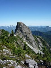
2. Summits. Strachan has two summits, south and north. The views from the north summit are much more impressive than those from the south (the view of the Lions is unimpeded), and so it is well worth hiking the extra 20 min or so it takes to get from south to north summits.
3. Strachan Meadows route: state of the trail. I hiked down the back of Strachan a little ways to check trail conditions. I could see snow, but it looked to me as though most, if not all, of the snow had melted away from the trail itself. Probably soon ok to take the Strachan Meadows route.
4. Ski run return. In past years the only available ski run to return by was a blue one (beginners’ run) a series of gradual switch backs ending you up at the down hill ski parking lot starting point. We found ourselves on a newly created run, the Bowen, an advanced run and obviously quite steep. We decided to try our luck rather than doubling back up, and a couple of us found sections of it a bit tricky to negotiate. Recommend sticking to the blue run for the return, if you plan to return via runs (and before you begin the hike checking the ski run map at the parking lot to orient yourself).
5. Timing. Saturday was the first time I’d hiked to Strachan by the Baden Powell/Old Strachan trail route. It is significantly longer than the Howe Sound Crest/ Strachan Meadows route. Allow 7 hours for the round trip (it took us about 6, including an extra half hour of needless hiking before we determined the location of the Old Strachan Trail.”