Category Archives: Day hike

Manning Park 31/07/10

Michelle on the Skyline and Silverdaisy trails:
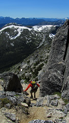
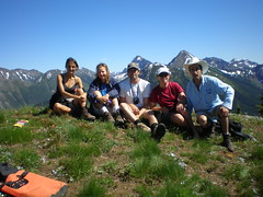
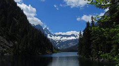
“No rest for the wicked! Three early mornings allowed us to maximize the mileage on this 500 something cumulative km trek spanning two provincial parks. Skyline as a cross over hike was a fun and unique experience with 5 hikers from Skagit and 4 hikers from Manning enjoying more sunshine than drizzle (and just a flash of lightning) before meeting up at Mowich for an enjoyable evening together. West of Mowich, Skyline does offer fine views of Ross Lake and the North Cascades. However continual views of Hozameen, endless peaks, valleys and the Lightning Lakes chain, kilometres of wildflower meadows, access to ascend Lone Goat and Snow Camp Mountain (a fine lunch spot enjoyed by both groups) is afforded by Skyline east of Mowich. Both groups also tackled a portion of the Hozameen Ridge trail 900 m west of Mowich (a spectacular ridge walk on a clear day). Reunited in Manning a dip in the river, some grub at the East Gate Diner, some refreshments from the General Store and cards at the Hamptons rejuvenated our band.

Of note – still some water trickling at Mowich, but I was glad I packed in all my water. Bugs (particularly flies) are better than last year in Manning, but were enough of a nuisance (as proved by my swollen eyelid bite). The snow is ALL gone and flower season should hit full bloom in the next few weeks.

The Silverdaisy trail is in fine shape, though easy to get side tracked and wander off in the beautiful meadows up top (pay attention and look sharp for the flagging). Silverdaisy makes you work for it, but the payoff of alpine meadows with a panorama of mountain views made for a very satisfied group. Mental or GPS breadcrumbs are useful for descent from the summit (easy to loose the route you travelled in on with little or no meadow footbed). The through and through hike may have shaved some time but navigation to Cayuse took effort and required GPS (lots of roads, lots of choices, little or no distinguishment on screen between active roads and now tree choked roads). An enjoyable adventure, but best (and more scenic) to just return via Sumallo Grove.

Summary: Nine enthusiastic hikers – check! Two cars + two phenomenally dedicated drivers – check! Two through and through hikes completed- check! Several frosty shakes and slices of pie consumed. Nine content hikers.

PS It’s a small world – 4 out of 8 groups on Skyline knew each other by 0–1 degree of separation, 2 groups of which were fellow Wanderungers.”

Flora Lake 31/07/10

Carolyne at Flora Lake:
“Eight intrepid Wanderungers set off to do the Flora Lake Loop. We were a well matched group and talked for most of the almost 10 hour hike! This hike has diverse vegetation and gorgeous views of surrounding peaks and the Chilliwack Valley. An interesting ascent through hemlock forest gave way to a traverse around an alpine bowl complete with wildflowers and then up over a wide pass. We decided to do a short detour to Flora Peak with 6 of our 8 going to the top for a look around. Then we started to descend to Flora Lake. This was the start of many descents! We kept remarking that it didn’t feel like we’d gained so much elevation, but we had: 1160 m. The trail continued traversing the west slope above the lake, weaving among the Douglas fir. Then came the first of many, many rock slide traverses. I had a moment of inattention, fell… and we ended up with an unplanned break as I got my knee bandaged up. No permanent damage done and on we went eventually descending to Post Creek but not before we could see Greendrop Lake peaking through the trees. At Lindeman Lake two of our crew braved the cold water for short dips. We couldn’t see them go in, but we sure could heard them! After what felt like a pleasant stroll to the other end of the lake, we descended again to the trail head. The trail is well marked and maintained throughout, there’s just one tricky bit at Post Creek – don’t go over the log bridge with signs on it saying ‘Greendrop Lake’ and ‘Trans Canada path’, take the path going to the left. Dinner at the Jolly Miller completed our day with a return to Vancouver about 11pm. Everyone agreed it had been a great day.”

The Chief 25/07/10

Keith on the Chief:
“The weather was phenomenal and the company even better. With some shuffling went to the around we ended up with one full car. We found parking (luckily), and set off up the Chief. Forgot how quick it is! We just went to the first peak and it was crowded, but it was clear and warm. I learned from the other people feeding the chipmunks that they do not like dried papaya. You don’t feed bears, why chipmunks? Given the opportunity I think they would attack 🙂 When the crowds leave in October they don’t have that food to depend on. They’re cute, but you do them no favours.

After a great lunch we headed down to the car and proceeded to Cabin Lake. A bit of a grunt up we got to the lake. The water was phenomenal. Clear, “diveable”, warm, sunny, and great company. What else do you need? It was much easier with no crutches or blindfold this time around! As one hiker said, “Every hike should end with a swim!” I agree.”

Needle Peak 24/07/10

Steve on Needle Peak:
“Of the hikes outlined in “103 Hikes” I think Needle Peak broke my Top 10. On a perfect day, I went with 4 well-matched Wanderung companions to a Coquihalla trail I thought was outside of my dayhike driving range and expected to get back late. The drive time really was not that bad because none of it was not highway (no logging road). We had dinner on the road and still made it home by 8 pm. More importantly it was well worth the effort.

Unlike many trails where 90% of the journey is a slog for a 10% payoff, this trail is 30% nice forest, and the other 70% is scenic ridge walking (with a few short scrambles thrown in). Every direction from Needle Peak is photo worthy, and though the “scrambles” did make my sphincter pucker for a few tense moments, they really were not that bad and the exposure was minimal. On this date, no bugs, and no snow except a few small patches. We encountered a large hiking group that included well know Wanderunger Grace, and in the parking lot met with Larry who was doing Yak peak who joined us for dinner at the Wildcat.

The only thing I can compare this hike with is one of my favourites: the Rim Trail at Cathedral Lakes. I give it a solid 2 thumbs up. Add this one to your list of trips this Summer (or even do it now as many other great destination are still under snow).”

Needle Peak, July 2010

Manning Park 24/07/10

Heather in Manning Park:
“Seven enthusiastic people set out on Friday afternoon, bound for a weekend in Manning Park. We all rode up in Chris’s amazing transformer van – everything from hot water to cook stoves to coolers to a bed was in there (although passengers slept in tents.) We camped just east of Manning Park, in a free and beautiful spot on the edge of the Similkameen River. Saturday had one person off fishing for the day, one person solo canoeing, and five of us heading up Skyline trail to Snow Camp mountain, in beautiful sunshine and completely blue skies. We had a few bizarre encounters with zombie-like people that were doing an ultra-marathon (100 km or 100 miles, depending on who you talked to!), including helping one woman down the trail to meet up with her companions. These people had run and walked for 30 hours or so, across the mountains and all night long, and we all agreed that it was pretty sad to see them so zoned out in such a beautiful environment. The vistas opened up to stunning alpine meadows, dramatic drops way down to the lakes, beautiful distant mountains, and an incredible variety of wildflowers. We took a total of 6.5 hours to hike this trail – hot but very rewarding, and the swim in Lightning Lake after was very refreshing. That evening five people drove back to the lake for a full-moon paddle, while two of us slept well! Sunday involved a lazy morning, and then canoeing and swimming in Lightning Lake again – enjoying the refreshing water and relaxing atmosphere. The evening was topped off by a good supper at the Manning Park Pub, and then a drive back to Vancouver in the evening sun. And enjoyable weekend had by all… Thanks to Chris for organizing, driving, and supplying the amazing extra equipment and comfort of the van.”

group on the summit

Statlu Lake 17/07/10

Michelle at Statlu Lake:
“Too much, the Magic Bus! Awash in a sea of emails, I would have needed to own the Magic Bus to accommodate the overwhelming response to this callout.

This Trek to the Undiscovered Country still took almost 3 hrs going as fast as possible in a well equipped 4×4. This officially 4×4 status road is *possible* for a car to take on (save for the last two short branch roads) at a much slower pace, but you’ll be muttering ‘Come on, come on’ and if you try and get anywhere at any speed your passengers will be shrieking ‘she’ll fly apart!’ as you exclaim ‘(We’ll) fly her apart then!!!!’.

If you disregard the significant driving effort, the hiking effort is minimal for the fine reward of Statlu Lake. Truly an area unlike what we would expect around here. Numerous high falls set in impressive box canyons (easy to see how there have been fatalities peering over edges). Seemed more like Pemberton – aquamarine lake in a rugged blueberry-rimmed bowl and old growth surrounded by gorgeous snow capped peaks. Though perhaps this should not be so surprising as you can drive these roads all the way through to Pemberton, if your 4×4 dares.

Due to time we opted to explore Statlu and the beautiful camp at its far end instead of ascending to the upper lake/viewpoint. Beautiful place to camp and explore. No wonder climbers scramble around this area. Thanks to the gentleman who built the new connector trail and bridges.

Note that the Harrison West FSR is posted as closing @ 25 km for bridge construction for 1 week sometime TBD between Aug 15 and Sept 15 – check the FSR road advisories for updates.”

Statlu Lake, July 2010

Mt Price 14/07/10

Andrew R. on Mt Price:
“Mike, Dan, Ellie, Ivana and myself left Park Royal at 8:30 am on our way to the Rubble Creek trailhead. We were met at the trailhead at 10:20 by Sharon. The six of us made our way up to the lake on an absolutely perfect blue-sky day. The Rubble Creek trail is now dry and almost completely snow-free all the way to the lake. We made our way past the Garibaldi Lake campground towards the Ranger Station where we would pick up the route to Mount Price. There is still a metre or two of snow on the ground beyond the lake, but it was very soft and melting quickly. The route to Price is tricky to follow (especially with snow on the ground) but fortunately the treed ridge is just open enough that we could see our objective and keep our bearing the whole way. On our ascent we found and lost the flagged trail repeatedly, but the group did a great job of route-finding as we slowly progressed up the ridge. A little before 4:00 pm we popped out of the trees on the ridge leading up to Clinker Peak and were greeted with seemingly endless views in all directions. Some of the group decided to make this their final destination and had lunch and soaked in the gorgeous views for the next hour. The others continued the ascent up the snow slopes with two of us reaching the peak of Clinker and one making the summit of Mount Price. We started down from the ridge at 5:00 pm. After a wet, post-holey slog back to the lake and a very long 9 km down the Rubble Creek trail, we made it back to the cars a little after 9:00 pm. The route described in Matt Gunn’s Scrambles guide is accurate and is the one we used. All in all, a fantastic, adventurous day with a great group!”

Golden Ears 13/07/10

Jennifer on Golden Ears:
“Getting an early morning start Valerie, Tamara, Jonathan, Darcy and Jen headed towards Maple Ridge and Golden Ears. Fortunately Valerie stepped in to drive as our driver did not call or show up for the hike (thanks Valerie!) The morning was clear everywhere except a big mass of clouds over Golden Ears. Our group set out despite the overcast skies, and after a lovely stroll through the forest, and scamper up onto the ridge, we were met with snow right down to the trees. Panorama Ridge didn’t give us any sense of its name as we wandered into a cloud to start our final push to the summit. When we got to the top, we were above the clouds and it was lovely and warm… but with no views. There were a brief couple of metres of scrambling but generally hiking all the way was possible. We sat at the summit trying Jedi mind tricks to part the clouds for almost an hour while eating lunch and relaxing. On the way down finally the clouds parted and we got wonderful views of the surrounding peaks and lake. Breathtaking as we ran/slid/butt scooted down the alpine sections of our hike. While not essential, ice axes did come in handy for some of us! Salmonberries galore kept us energized for the long hike out. Everyone hiked at roughly the same pace, and total hiking time was 5.5 hrs to the summit, 4.5 hrs back to the cars. We ended this long but fabulous mid-week escape with milkshakes and dinner at a local diner. Thanks everyone for a great Tuesday!”

Gate Mountain 13/06/10

Steve on Gate Mountain:
“Five of us set out to tackle this one, but our luck on this trail was not great. First off, the trailhead sign shown in every online resource is gone and replaced by a plastic bag wrapped around a stick. 103 Hikes also quotes 5 km from Alexandria tunnel, but it is actually closer to 3.3 km. But once we figured that out, up we climbed. Markings were “ok” with basically no more mishaps than the average hike of his type. Unfortunately the weather turned at the top (it was hot and sunny below). As we got to the ridge, the bushwhacking began. Not as bad as some places but it did slow us down. Then we ran out of markers, and the snow started to pile up.

Combine all of those elements and the fact we had reached our turn-around time, we decided to cut it short only about 85% of the way to our goal, and having never actually seen Gate Mountain itself (even from a distance). In fact, 103 Hikes mentions most people don’t go all the way, to which I ask: why do this hike? As we descended, the weather improved again! If this had happened up top I think we’d have pushed on for 30 more minutes.

Now, here is the gross part. After actually discussing that Fraser Canyon is a tick infested area, Michelle was bitten by one and it was burrowing into her skin, so after a 2 hour detour to the Chilliwack Hospital emergency room our trip came to a close.

On the whole I would not recommend this trail. The First Brigade trail next door is more interesting (but watch for ticks!).”

Panorama Ridge 13/06/10

Chris M. on Panorama Ridge:
“Starting out, the clouds (and rain!) didn’t look promising. But having an Alex sunshine guarantee, we didn’t worry. The first 5 km of the Rubble Creek trail are snow free. The meadows, lake & mountains are still covered. With help from Evgeny’s GPS we made our way to the west end of Panorama Ridge. It was a little steep but the snow was good. Valerie used her micro spikes, while the rest of us used an ice axe. Snowshoes were not needed all day. About 2/3 of the way up the clouds and wind increased. We couldn’t see anything. However, Irina said the weather report called for sun in the afternoon so we continued. Sure enough, around 12:15 the clouds started to break and view opened up. Everyone was happier! We took the standard route down with some shortcut-fun downhill glissading. Then made our way across the meadow and back down the trail. Finished up with dinner at the Watershed Grill in Squamish.”