
Paul T. on Mt Gardner:
“I set the meeting place for this trip as the ferry terminal ticket office. Because people will not necessarily be arriving at the same time I think a better place to meet at the terminal is the waiting room in order to more easily identify group members. We wound up a small group (just two of us) but met several other Wanderungers on the ferry on the way to the same hike and joined them. One of them had brought ribbon to better mark the last part of the Crippen portion of the trail. There are now ribbons marking the turn off to Mount Gardner Road. It took us less than three hours to get up via the skid trail, and about two returning by the trail that comes up near the platform on the west side of the north summit.”
All posts by andy
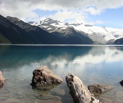
Garibaldi Lake 06/09/08
Pablo at Garibaldi Lake:
“Four of us headed to Garibaldi Lake Saturday. Great Group, great weather, no problems on the road. Garibaldi seems easier without snow. The lake and the glaciers looked great as usual. The parking lot was pretty full. We picked up a lost hiker from another group. By the first viewpoint he found 3 members of his group (strange place for a meeting point). When we arrived at Garibaldi Lake, we had already found 28 of his 33-member group. Now I understand why the parking lot was full, with 33 cars for a single hike. After lunch and a nap, we returned to the parking lot and drove back in our fuel efficient hybrid car.”
Garibaldi Lake/Panorama Ridge 06/09/08
Su-Laine at Garibaldi Lake and Panorama Ridge:
“Seven hardcore backpackers plus myself headed up to Taylor Meadows on Saturday. Three went up to Black Tusk that afternoon while us other five mere mortals enjoyed a gentle walk to Garibaldi Lake. After surviving a freezing cold night and morning, when the main topic of conversation over breakfast was winter sleeping bags, we all headed to Panorama Ridge on Sunday. We had the incredibly good luck to be doing this trip on a clear weekend with blue skies, and Panorama Ridge was the most eye-filling hike I’ve ever done. September seems to be a good time to do this trip; the trail was dry, some of the wildflower show was still happening, and there were plenty of good campsites at Taylor Meadows.”

Mt Gardiner 06/09/08
Tim on Mt Gardiner (NOT Mt Gardner!):
“Tim and Dean climbed Mount Gardiner (2406 m) above Place Glacier on Saturday Sept 6th. We drove up to Pemberton on Friday night after work and camped at at Nairn Falls. On Saturday morning, we ate excellent bacon and eggs at Grimm’s Gourmet on Frontier St. at 7am and were at the trail-head by 9am. The hike to Place Glacier is 1400 m and very steep. It takes about 4 hours. Worth every drop of sweat. There is an impressive waterfall early on. Also a tricky headwall just below the glacier that requires scrambling some narrow ramps with a little exposure. Place Glacier is phenomenal. From the Glaciology Huts (1800 m), it is another 600 m (2.5 hours) to the summit of Gardiner. Matt Gunn’s book is very useful. The mountain is a superb ridge scramble with no real exposure. The weather was good. The views were outstanding. On Sunday we set off to scramble Mount Oleg, but stopped halfway there, at a sub-summit on the NE ridge. Axe and crampons proved useful on the second day. To reach the summit probably requires crossing a glacier with associated hazards. There was much evidence of mountain goats (fresh prints) but no sightings.”

Howe Sound Crest Trail 06/09/08
Michelle on the southern section of the Howe Sound Crest Trail:
“The scenery did not disappoint! A shady forest trail provided pocket views all along the route. Each summit was more impressive than the last – St Mark’s, South and North summits of Unnecessary provided even more spectacular views than the last. That being said, ignore the mild elevation and grade stats on this hike – your actual gain tackled is far more than 600 m as the trail rises and falls like a roller coaster and is rugged, rooty and rocky. Especially past St Mark’s – think upper Grouse Grind. As well – WATCH YOUR MARKERS! Both ways! There are several trails in the area – make sure you make the turn on switch backs and don’t go straight on by (on what looks like the path). Also, as a friendly couple we passed kindly shared – there are multiple branches on return and many have gotten lost, especially from taking a left fork returning from Unnecessary. When leaving Unnecessary DO NOT take the first trail to the left – stay to your RIGHT and follow the rocky bluffs as far as you can, down to the first no-name mini-summit/bluff you encountered on your assent. Then you will descend back into the forest on marked trail (and again watch your markers).”
Blowdown-Van Horlick divide 06/09/08
Chris at the Blowdown-Van Horlick Divide:
“Jana, Peter and I braved the unknown to visit what turned out to be a beautiful untouched wilderness on the Blowdown-Van Horlick divide. The Blowdown road was in good 2wd condition – some minor rutting and a new culvert at 9 km. Also, a new waterbar on the hill past 9 km and possibly more further along (you may have minor scraping in a 2wd). We intended on taking Branch 4 at 9.5 km but it has just been decommissioned – the culverts and bridges have been pulled and a big rock blocks the road at the start (but could be avoided in a narrow 4wd). The road has been copiously waterbarred (5 in 20 m at one point). We walked the road to the end (just before an avalanche path – perhaps 2 km), bushwacked 100 m and climbed a second avalanche path about 400 m to steep meadows. We sidehilled to the upper valley (tricky due to wet plants) and wandered beautiful meadows to the pass. Descending into the next valley, we camped near some small ponds. In the morning, we checked out the main lake (beautiful) and spotted some mountain goats high on a ridge. We meandered back up to the pass along a different route and descended back into the Blowdown valley along the edge of the scree slopes (lots of rocks and a short brushy bit just before a wetland so slow going). Definitely going back and spending some more time exploring what looks like easy ridges to the NW.”
Blackcomb Peak 06/09/08
Ahmad on Blackcomb Peak:
“Our hike started from Lot #6 and on the ski runs. We discovered that hiking on ski runs is not a bad idea. We collected over $10 worth of coins. After we reached Blackcomb lodge, which was closed, we hiked to Seven-Heaven Chair to get on the ridge that leads to Blackcomb Peak. The ridge is rugged and rocky. I found that there were two tricky sections and one of them was moderately exposed. Four of us summited after a 6 hour ascent. I found the views from the peak are superior to those from the Musical Bumps. On the way down, we took a different route. We headed down to Spearhead’s col, on to Disease pass, and then down to Blackcomb Lake. Many loose rocks especially on the way to Spearhead’s col. The whole trip took 10 hours. Special thanks to Chris for providing me important information of this scramble.”
Cypress Peak, 1 Sep 2008
Tim on Cypress Peak:
“Tim and Firas scrambled Cypress Peak (2,083 m) on Monday 1st Sept. This is a fairly easy scramble to a pointy-looking peak just north of Tricouni Peak (between the Squamish and Cheakamus Valleys). The road access is excellent (2wd all the way to the trailhead) although the updated info from Cairn Publishing was also helpful (https://www.cairnpublishing.com/updates/cypress_road_update.htm). The trailhead is easy to find. The route is simple and relatively short. One moderately difficult step on the north ridge makes it interesting. Climbing helmets are essential, however an axe is not required at this time of year since minimum snow was encountered. Also, Roe Creek is easy to cross at this time of year. It took us about 3.5 hours to reach the summit, providing excellent views of Tricouni Peak, Mount Brew and Mount Fee. We were very lucky with the weather because the cloud lifted at about 11 am.”

Brandywine Meadows 01/09/08
Su-Laine at Brandywine Meadows:
“After three cancellations, five of us piled into one car and had a super afternoon at Brandywine Meadows near Whistler. Thanks Ahmad for the new driving directions. Don’t let the short (6 km) distance and the word “meadows” make you think this is an easy hike – it was the muckiest trail I’ve done in a long time (as one person put it, it became no longer about mud in his socks, but socks in his mud), and steep with lots of fallen trees and some confusing trail marking that caused our group to be separated for about an hour on the return. The meadows at the top, with mountains in the background, are a very special place though and this was a trip to remember. Flowers were blooming, but starting to die off – better get there soon if you want to see them this year. We met up with Carole’s group and had lunch together. “

Mt. Seymour 01/09/08
Carollyne at Mt. Seymour Norvan Falls:
“Unfortunately, sometimes weather doesn’t co-operate, and today’s plan to hike Seymour was one of those occasions. Seven of us eagerly went up to Seymour, hoping that somehow the cloaked North Shore would reveal itself when we got there, but the fog was so dense, the end half of the parking lot was invisible and the buildings disappeared too. We all agreed to hike to Norvan Falls instead, and had a great hike with lunch at the falls, and soaked up the sun at Third Debris Chute beach on the return trip. The water levels in all the creeks are now quite low, making it an easy hike, although muddy at times. We met two backpackers on an early return from Lynn Lake – due to the weather. Momentarily, some of us thought about trying Seymour again this afternoon, but the pleasant sound of the Lynn Creek washed that idea away.”