All posts by andy

Keith's Hut 21/01/12

Dennis at Keith’s Hut:
“From the beginning, this was a hike full of warnings and red flags. The Duffey Lake area is known for avalanches. Going into the weekend the Canadian Avalanche Centre had a high avalanche warning for the region. On this note, I received more than one stern warning from concerned Wanderungers. Nevertheless, four brave souls (Ian, Liz, Calum and Rita) joined me on this ominous trip.

Recent heavy snowfall and cold weather have made the Sea-to-Sky north of Squamish a nightmare for anyone not equipped with a 4wd or chains. As we drove towards Squamish, the warnings continued with Mountain Radio describing the road past Squamish as a sheet of ice and to avoid driving in that direction if possible. The drive up was a slog in stop and go traffic through a couple different sections on the highway due to accidents. If you plan on heading to this region in winter weather, be prepared for these kinds of delays, especially on weekends when many inexperienced drivers head up to Whistler. In total, the delays added 2 hours to our travel time which I had not anticipated.

The parking lot is a pullout just off the highway and was easy to spot with 3 other cars already parked there. The hike up to the hut was straightforward on a well-marked and frequently used trail. The new snow however made for a bit of a workout breaking trail. The evening was spent pleasantly socializing and drinking wine with seven other backcountry skiers also staying overnight. Great location and lots of firewood. Despite all of these amenities, Calum feeling more adventurous and much more energetic than the rest of us, dug a snow cave and slept in it overnight.

The next morning we quickly ate breakfast and left the hut with plans to do some light exploring before returning to the car. I had all but abandoned my original plans to summit Vantage. But, after judging the snow conditions of the route leading to the Matier-Vantage col, we decided it was safe to make our way up to the col. The trail and cairns marking it are hidden under snow at this time of year, but a route is fairly obvious nonetheless. It took us an hour to the col and back. At the top we were rewarded with spectacular views of what I assume was Joffre Peak.

The drive back was again sluggish due to winter road conditions and accidents. So, I repeat, do not attempt to drive here without a 4wd or chains. Finally, I cannot say enough good things about everyone who joined me on this hike. All strong hikers who radiate positivity. I would recommend them to any organizer. Thanks again guys for making this a great trip.”

Alice Lake 07/01/12

Stephen H. at Alice Lake:
“Rebecca, Colleen, and I headed up to Squamish for a pleasant rainy-day hike in Alice Lake Provincial Park. We set off on the Four Lakes Trail, enjoying the easy walk through the lush forest. Finally, we broke a sweat ascending DeBeck’s Hill. Unfortunately, fog obscured any of the reportedly superlative views. All in all, it was great 3.5 hours in the woods.”

North Shore Exploration 07/01/12

Chris M. exploring the Ballantree area:
“Rui, Chris & Celia agreed to wander with me, above British Properties. We started at Ballantree Park. Fairly quickly we left the trail and headed up through easy forest. We found a few old mountain-bike trick constructions. We also found a few twisted trees (which we decided must be caused by lightning). We turned west and made it as far as Brothers Creek before turning around and heading back. At first on the Baden-Powell but then back off-trail. Though we continually crossed over unmarked footbeds and trails. Instead of the rain in Vancouver below we had light snow fall on us all morning.”

Crazy Mountainbikers!!

Solstice cycling 21/12/11

Steve’s Solstice bike ride:
“Close to a dozen signed up for this trip and I’m going to call it a success. Completely foreign to any other callout I’ve ever done (being urban, and so low key in terms of athletic effort), it was a great thing to do on a weeknight. A few of us had lights on our bikes and helmets (mine here: https://tinyurl.com/6rz4z87) but I think any future incarnation of this event requires far more effort on that front! We turned a few heads, but we could have turned more.

The convoy set off from Wall Centre and St. Pauls and hit a variety of sites including: the Woodwards displays, Lost Lagoon Tree, the willow on Pacific and more. We ended our ride with snacks and hot chocolate at Bridges.

We had a perfect night of weather and to top off that the Solstice events at the Roundhouse, Olympic Village, and Granville Island really upped the entertainment factor. That being said, I wonder if the ride could have been equally as enjoyable on a different night, freeing us up to actually spend more time at each of the False Creek (or elsewhere) Solstice festivities and the ride could have stood on its own.”

Mt St Benedict 18/12/11

Irina on Mount St. Benedict:
“This last minute trip only found three participants as we got out for a hike, hoping the forecast will be correct and it actually clears up in the afternoon. No such luck, just the teasing blue patches of sky running above our heads.

Gravel road, albeit with some pot holes, is in good condition for a 2wd. Took us less time than expected to get to the top, only 3 hrs: lack of snow over the last 2 weeks and only 5 cm of fresh powder from the night before meant that the trail was fairy well consolidated. It appears to be quite a popular place, and the existing track sure made our hike a lot easier. Boots to the lake, snowshoes from the lake to the summit and crampons for the way back (some portions of the trail between the summit and the lake are quite steep). Logging road is a running stream but one can still find dry rocks/low water to not soak the boots. Must be a nightmare during the spring melt.

Contemplated going to the nearby North summit (McKay Peak) but none of us were much motivated given low visibility. Good day nonetheless, as at least it didn’t rain or snow on us and we were treated to warm temperatures and lack of wind. A bit too long of a drive for such a short hike and no views, though. Trip report and photos on LiveTrails.”

Evgeny at the lake pano

Elfin Lakes 04/12/11

Dan at Elfin Lakes:
“Eight of us headed out bright and early to Squamish and drove up Mamquam & Garibaldi Park Roads to the Diamond Head Trail parking lot. We had a 4×4 with 2 set of chains and a 2wd truck with one set of chains – both made it up easily with no traction issues.

Blessed with recent dumps of fresh snow in late November, we put on our snowshoes right away. 1:15 later we were at Red Heather Shelter basking in the warm winter sun. The winter route to Paul Ridge was well-trodden and there were many groups of AT skiers – and only one snowshoe group – that we hiked past on the way up.

Countless photos and 3 hours later we started descending on to Elfin Lakes. Both lakes were solidly frozen – early by normal standards. There were easily 3-4 metres of snow at the shelter. Surprisinigly, only a couple of parties remained and it was fairly quiet inside. We lingered for an hour, soaking in the warm sun, and made our way back. Headlamps were used only for the last 45 minutes. And we treated ourselves to a great meal at the Shady Tree after, conjuring up next week’s adventure at the Musical Bumps.”

Mt Fromme 30/10/11

Chris M. on Mt Fromme:
“Two people joined, but transit let one down. So it was just Andrea and I who spent 2 easy hours splashing up and down a creek on Fromme. It was relaxing and fun for both of us to search out little water treasures and try to capture them on ‘film’. We each had some shots we were happy with. And rubber boots were a blessing. There will be another trip here…”

Fromme Forest Falls

Mt Gardiner 15/10/11

Evgeny on Mt Gardiner:
“When I made a callout I wanted it to be a long but regular scramble, however it appeared to be another megahike with mountaineering added to the mix. In total, it took 14 hours 30 minutes for the whole trip but it included more stops than we expected.

Knowing that we have to go beyond Pemberton and the days are short, I decided to start very early. So we left the parking lot at 4:30 am. Two of us were at the trailhead right after the sunrise and started hiking at 7:53 am.

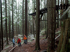
There is a nice waterfall not far from the beginning of a trail but overall till it gets to the open, the hike through the forest was quite steep and uneventful. There was a tricky Place Creek crossing because the temperature outside was just above zero and most of the stones and deadwood we supposed to hop over were covered with ice. On the way up we crossed it without a problem. Right after the crossing the ground was frozen and covered with frost icing till the second crossing, which wasn’t a problem at all since the creek was very shallow and narrow there.

The forest opens up a bit when you come under the cliffs where we observed two magnificent frozen waterfalls. Though this area hasn’t been covered in snow yet. Just around the cliffs we came to the well known smooth slabs. I was worried a bit that they might be icy this time of the year but fortunately they were very dry, perfect for slab walking. Therefore my goal was to pass this point on the way back before the dark, so there will be no complications.

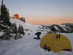
I was very optimistic about this trip as we reached the huts in 3 hours 30 minutes, that’s a quite good speed, and the weather was unbelievably good: clear skies, cool but not cold and no wind at all. The mountains covered with fresh snow provided awesome 360 degree views. After a short food break near the glaciology huts we started to traverse around the lake to follow the south east approach to the mountain. We aimed for the notch in the ridge. Snow on the slope was fresh and 40-50 cm deep and we could clearly feel the solid ground beneath that has no layers of ice on it. Going up over the snow covered talus and boulders were easier than I thought, the only difficulty was the depth of the snow. Irina took snowshoes with her and it helped her to make her life easier, but eventually we came to the steeper part and she had to pack them back because the fresh snow on the steep slope didn’t hold well for snowshoes. We were doing very well without crampons since the snow was dry and fluffy. As we came closer to the notch we ran into a problem.

The amount of snow was not enough to use it to go over the hidden slabs beneath and we couldn’t see where they end or have convenient cracks or breaks to cross them. So, we were probing the snow with poles and made several failed attempts to climb them until we found the place where the smooth part was small enough to dig out a handholds and push ourselves up on the top of the ledge, which led to the passable slope to the gully. I used a pole in one hand and SLR camera in the bag in another (Seriously! It works quite well as a hand snowshoe!) to help me going up the steep slope.

Then I made a mistake… going up was not slippery and despite the increasing slope angle I didn’t decide to put my crampons on in the gully. Initially it went quite well, though the slope was very steep, may be 60-70 degrees, the footing was very stable. But approximately on the 2/3 mark to the top of the notch the surface under our feet and a rather thin layer of fresh snow became a bit icy and impossible to kick in. Irina and I started to feel that it doesn’t hold us well anymore. I doubt that falling down would have killed us but considering the steep slope and some stones at the end, it would have been a very long tumble with a possibility of some injuries. And here comes a trick of a day: Irina noticed a stone that was barely poking out of the snow one metre to the left of us. We decided to try to use that stone to sit on it and put on our crampons. Yes, it felt pretty much like sitting almost half in the air. 🙂 Fortunately, it was flat enough on the top to sit on it but we still needed to keep good balance, especially when attaching them to our boots. We made it quite well but spent almost 40 minutes to do that. However, now we could ascent that slope further by hanging basically on the front teeth of our crampons kicked in in the very hard packed crust of snow. Next 20 metres of ascent took us 20 minutes more as we made our steps extremely carefully. Then the very top part of the gully was filled with the waist deep soft snow and, since I led our small team, I had to use my knee to dig the space a bit before I could kick-step my foot in. We safely reached the top of the gully at 3:35 pm.

The scramble out of the notch to the peak was enjoyable. Despite a bit of exposure in the notch it has good foot and handholds, the rest was a piece of cake. Right near the summit I had my epic fail situation when I stepped on the large loose rock and fell, while shooting my summitting video. But it was a flat area, so I ended up only with few bruises. At 4:18 pm we summitted. It was a scramble that turned into mountaineering but we made it!

Calm weather gave us an opportunity to enjoy the views and feel the warmth of the sun instead of just making the step on the top and rush back like happen to our previous hike this year. Since we didn’t want to use that steep gully to descend we were looking for other route on the other side of the mountain but it was steep and covered in snow. We decided that it would be too risky to go that way. From the top it seemed like if we would manage to climb to the other side of the notch then we might have an easy descent down. Therefore, after taking pictures and having food we went that way.

Except for the very short climb to the other side of the notch where we had to dig snow for hand holds the rest of the scramble down was quite easy. We could have saved more than an hour if we went this way up but I don’t know if we would consider down-climbing to the notch having snow on the handholds if we had chosen this route up.

The remaining part of the trip down to the lake was mostly smooth with just a few postholing in the process. We made a slight shortcut to save time as it was getting dark very quickly. We were on the top of the slabs part when it was after the sunset and just a few minutes of light left. As we successfully descended the slabs it became completely dark but the goal was accomplished. We turned our head lamps and proceeded to the car. Right after the frozen waterfalls we had a bit of a difficulty finding the way in the dark since it’s not marked enough for a night conditions but my GPS came to rescue in the difficult times. When I crossed Place Creek on the way back I slipped on the stone, had a refreshing dip into the creek, and got few more bruises. I used that stone on the way up but now it had an ice cover, invisible in the dark. The rest of the trip was without other accidents.

We were back at the car at 10:18 pm. We spent 8 hours to ascend, 6 hours to descend, and 30 min on the top basking in the sun.

For the pictures and videos check https://www.livetrails.com/report/3838/0/Mount_Gardiner

Mount Gardiner 15.10.2011 108

Helm Creek 15/10/11

Steve on the Helm Creek cross-over:
“This was a manly trip. Five rugged men (Ben, Greg, John, Steve and Cam) with full packs dumped a car at Rubble Creek and then entered Garibaldi Park from the Cheakamus River end. We took snowshoes not being sure exactly what kind of conditions we’d be facing. We did really well on the ascent and as we lunched at the Helm Creek campsite we realized we were ahead of schedule and could afford to hike further before camping. There, as the sun beat down on us, I was convinced we wouldn’t need the snowshoes… but I was wrong. Another 200 m of gain and we hit the Cinder Flats completely covered by powdery snow. It was beautiful, and warm, ideal snowshoe conditions. We decided to go up Cinder Cone and take a look, the views of Black Tusk, Panorama Ridge etc. were great from there. Though we had prepared for “chilly” camping, some of us may have been a little under-prepared for a -15 C night on snow (at least I was). My feet have only just thawed as I type this. The exit via Garibaldi Lake (still snow free) was quite scenic as many of the leaves had turned. The Whisky Jacks were in full force and the photo weather of the lake itself as nice as I’ve ever seen it. A big thanks to Cam who shared his Winter camping tips with us!

For anyone planing a trip next weekend into Garibaldi, I’d say your window is closing. Any crossing like we did will be a winter trip for sure. Skis or snowshoes mandatory. And if you are planning going to the lake, I suspect ice and snow are coming soon.”

Helm Lake cross-over

The Lions 15/10/11

Malin at the Lions:
“Three people joined me for a hike up to the Lions on Saturday. We arrived to the Lions Bay parking lot at around 8:30 am and due to the beautiful weather we found it full. However, the walk from the school parking lot took less than 10 minutes and saving those extra minutes is in my opinion (and my hiking companions agreed) not worth getting up an hour earlier for. The morning was a bit chilly, but it quickly warmed up. For some reason the logging road up to where the trail to Mt. Harvey turns off to the left seemed shorter than usual 🙂 The trail was nice and dry, but got a bit icy once we got over 1000 m. The scramble up the rocky slope is easy, but this time of the year many rocks are covered with ice and frost so be cautious! There is also a small, but slippery snow field half way up the slope. My microspikes came in handy, but the snow field can be avoided by climbing higher up on the rocks. Our destination was the base of the west Lion where we had our lunch. The 360 degree view from there was amazing and I would actually call it a sub summit rather than base 🙂 We took our time on the way back and stopped several times to enjoy the views and sunshine before the trail took us down into the forest again.”