
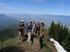
Merewyn on the Historic Mushroom trail:
“The day started out a bit shaky as our bus never arrived leaving 3 of us stranded at the SkyTrain (apparently they were short a bus driver today). Luckily one of our fellow hikers was able to swing by and pick us up en route to the trailhead. So much for our transit hike but thanks Melanie! Other than that and a few cancellations the day before, the hike went off without a hitch. Over the course of the day, we did a figure-eight loop through the Lower Seymour area, hiking 6 different trails in total, with a stop at the Historic Mushroom, a tree stump that used to be an information post for those hiking up the mountain (and the end point for those driving up) in the early 1900s. The trails were fairly dry, easy to follow and the group was great fun to hike with!”
Yearly Archives: 2008
Gambier Lake 01/06/08
Andrew at Gambier Lake:
“Six of us made the trip to Gambier Lake on Sunday. The trail has been recently re-flagged and had obstacles cleared (by, coincidentally, a local we met on the bus ride home) and is dry and easily followed all the way to the lake. At the lake, Gabriela and Erin went for a paddle and Andrew went for an unintentional swim. The canoe has been joined by a plastic runabout which is slightly tippy. At the general store (with longer opening hours!) we ended the day with ice cream, tea, and Strongbow. All the ferries matched up as planned and we had minimal waiting time.”
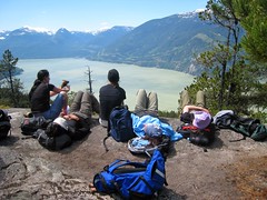
Levette Lake 01/06/08
Carollyne at Levette Lake:
“Five of us hiked to Levette Lake (8 less 1 sick, 1 asleep and 1 at wrong meeting spot) via Copperbush Pond trail and back on Skyline and Fraser-Burrard trails. Trailheads are poorly marked for first-timers, but the trails themselves are well-marked, gorgeous moss gardens. The viewpoints would be even more beautiful on a clearer day. Copperbush Pond shelter is now a flattened pile – probably blown down as were quite a few trees on the trail. At Levette, Amy and Eric were brave enough to swim and get out into the even cooler air. Lake-front cottages, tents and the sound of a generator reminded us this is not a park. We shared the logging road section with several trucks, a couple of ATVs and dirt-bikes. Thanks to Andy’s kind warning, neither car bottomed-out on the access road – just how fast was he was going? Howe Sound Brew Pub ended a great day.”
Elk/Thurston 31/05/08
Ahmad on Elk/Thurston:
“Five of us did the hike to Thurston peak on a clear day. Most of snow has melted from the edge of the south face of the ridge. It was just wide enough to walk on it most of the way. We didn’t need to use our snowshoes. The last kilometre was covered by snow. We opted to hike it and break our trail. There was about 1.5m of snow when we reached Thurston peak. The ridge offers better views that the peak itself. We met several groups on the way up. None of them summited it. Mount McGuire and Cheam seem still have loads of snow. It took us eight hours to do the hike.”
Upper Shannon Falls 31/05/08
Michelle at Upper Shannon Falls:
“A fantastic day! A full crew of us headed up to Shannon Falls on a perfectly sunny day. To steal Steve’s description “a totally under-rated trail”. Charming forest trail, waterfalls for a lunch spot and a quick 15 minute jaunt past that a 180+ deg view up top of the ridge – what more do you want? No more shall we simply drive on by this one. A great uncrowded alternative to many of the other bustling trails in the vicinity. We truly had a stellar crew, great conversation and shared a bite to eat after in Squamish. A real battery re-charger of a day.”
Slhanay Peak 25/05/08
Brenda at the Slhanay Peak:
“I picked this hike thinking we might have a rainy day and that we would at least be protected by the trees. Fortunately for Greg, Igor, Annie, Michael and I the forecast was wrong and we enjoyed a cool, sunny day with impressive views from Slhanay Peak. Our day did not start off too well – one no show and one person who missed out on the hike which may have been due to a confusion about the meeting spot (Sorry!). Once hiking we stopped several times to compare my crappy map with our compass and GPS since we thought we must be on the wrong trail. It ended up that the trail is actually well marked, we just did not trust the markers. Now that I have done all 3 peaks of the Chief as well as Slhanay Peak I would have to say I prefer Slhanay Peak. You get a view of the Chief that you do not normally see plus there were no other hikers on the Slhanay Peak trail (unlike the Chief which is usually PACKED!)”
High Falls Creek 25/05/08
Gabriela at High Falls Creek:
“A group of 6 of us headed out to conquer the High Falls Creek trail and with perfect weather it didn’t take us too long to complete the hike. There was no snow where we were but you could certainly see how much is left to melt in the mountains. The waterfall itself was certainly gushing with all the melting winter white. Everybody was fantastic and we had no problems (other than a slow group of hikers who after an evil glare or two we passed *grin*). On the way back four of us stopped in Squamish for a bite and learned a lot about this province thanks to Chris!”
Grey Rock Lookout 24/05/08
Christian at the Grey Rock Lookout:
“The 6 of us entered the trailhead at 7:15pm. This old Baden-Powell route was quite wide at the start. Lots of roots and ruts to step over. No snow, no mud. We separated into groups of two, as we went up and down various twisty and steep trail sections. Conversation was light and spirited. We kept changing conversation partners along route. We noticed all the creek crossings had been improved with new bridges. We reached Grey rock by 8pm, and looked out over Deep Cove, Poco and Burnaby. We could see all the tall Burnaby towers far away in the distance. Unfortunately, there were trees blocking the views East and North of us. We could not see the fabled Twin islands I was hoping to point out. We walked out before dark, and half of us went to the Raven pub for a pint and a meal. A few good laughs to end a nice evening. Trail was steeper than expected. Overall a worthy trail rain or shine for a good light workout.”
Rainbow Lake 24/05/08
Darcy at Rainbow Lake:
“Five of us headed up to Whistler for the trail to Rainbow Lake. The first hour of the trail was snow free. We donned snowshoes to travel over a fairly hard packed snow, three to four feet deep. Bob opted to use back country skis with skins. As the trail was hidden and the tree markers often spread out, we veered slightly off course a few times. Ahmad was great at using his compass to navigate, and Eric set us back on course as well, using GPS, his “not lost tool.” There were several “post holes” in the snow where hikers had broken through the upper crust. There were also many snow bridges, thick in some spots and dangerously thin in others. We had to hop across a couple of creeks, and detour higher off trail to find a way over one. There are two large creeks on the trail. We crossed the wood bridge over the first creek, but the platform for the second bridge was still removed for the winter. At this point we had almost reached Rainbow Lake, so we diverted our hike towards Gin and Tonic lake. We took a break with a beautiful view of Rainbow mountain and turned back around 4 pm. The day was sunny blue sky warm and the snow was slushy slippery downhill on the return trip. Constance was happy to see two black bears on our drive home.”
Mt Gardner 24/05/08
Carollyne on Mt Gardner:
“‘So close, yet so far’ could be the motto for this group setting out for Mt. Gardner. We eventually all saw the great views atop the north summit, but not until we’d hiked to the radio tower. Not finding a trail to the summit, we doubled back to go up the well-travelled, steeper south trail adding 2.5 km. Later, following those stupefying “North” signs, but feeling we were circling the summit again and again, 2 of our group disappeared. After a fearful wait, Evan went back to find them. He returned to report our missing hikers were on the south summit and weren’t moving. We asked about a view, platforms etc. and realized they were on the north summit, not the south. We joined them and their chuckles in about 5 min. Hindsight has me convinced we found the trail from the radio tower to the summit, but we just didn’t know it at the time. Energetic, cheerful new Wanderungers helped make this a really fun trip. We wrapped up at Doc Morgan’s followed by Amy’s relaxing shoulder massages on the 9 pm ferry.”