Tag Archives: Chilliwack

Radium Lake 29/08/09

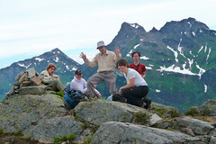
Steve at Radium Lake:
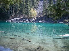
“I was warned by a number of people that Radium Lake was more of a hop off point to other great destinations like Mt. Webb or MacDonald. It turns out they were right. Although the trail was pleasant, and extremely well marked, given the elevation gain and distance, it seemed to fly by. The lake itself was unimpressive and there were only peek-a-boo views of the surrounding peaks. However it looked like a great spot for a campsite/basecamp, and many varieties of berries were abundant.

The only potential obstacles on this trail was the numerous bridges, one reported to be out. I’ve seen bridges in far worse condition than this one though I could see where the “break” was. In our case, there was no problem crossing the bridge OR just crossing the stream below. I’m unsure why no one has repaired the bridge, it looks like an easy fix.

Good company though, minimal bugs, and this time we avoided that pub and opted for pizza instead afterwards. Next time, I plan for an overnighter at this destination and intend to check our the surrounding peaks.”

Mt McGuire 23/08/09

Su-Laine on Mt McGuire:
“New hiking objective for 2010: finish Mount McGuire. We didn’t make it to the top, but the northwest ridge approach that people have been discussing on Clubtread this year is definitely doable as a day hike from Vancouver. It’s a beautiful area.

Getting to the trailhead from King George station in Surrey took an uneventful 2 hours via the Tamihi Creek FSR. There are reports of locked gates and fallen trees on the road, but we didn’t see any. We were in an SUV and the only other vehicle in the parking area was a Delica. Wide trucks might not be able to get past a couple of rocks on the road. The road is better than the one to Cheam, but I doubt 2WD vehicles could make it up there.

In a routefinding error out of the “don’t ask how we managed to screw that one up” department, we climbed the rockslide on the left rather than the right near the beginning of the hike, in spite of the printed instructions we were carrying and some flagging tape. After 45 minutes of some of the toughest scrambling I’ve ever done, we figured out that it was wrong and downclimbed. The rest of the hike was straightforward by comparison, but there were a few scrambles up steep slopes, and we spent quite a bit of time figuring out where the trail and turning points were. The route mostly follows a mountain goat trail, and is very obvious in some places but not others.

I was wearing a helmet, long pants/sleeves, and bicycle gloves and was glad to have all of them, especially gloves because the rocks that you have to scramble over feel like sandpaper.

We reached a meadow in which you descend into a valley before going up to the summit. Views were good from there and we realized that we weren’t going to be able to get anywhere more interesting by our turnaround time, so we relaxed and feasted on wild blueberries before exploring the ridge a bit more and heading back. It was a very fun day, and we’re all more experienced navigators now. I’d be happy to go back.”

Mt Laughington 12/07/09

Michelle having a laugh on Mt Laughington:
“Fact: GPS invaluable for getting you to and on trail smoothly (GPS is the way to go on this one). Fact: steep and loose rock logging road = 4WD required (though very few water bars or bad ruts/gaps = minimal clearance issues). Fact: trail is almost snow free (snow remains, but patches do not obscure path) and once on the trail proper (to the knoll), foot bed is well enough worn and well re-flagged. Fact: book time 4.5 hours? make it 5 – 5.5 (we took almost 6 with pauses and breaks). Fact: we saw Ogopogo. OK, well at least an ethereal cloud that magically formed before our eyes over Airplane Creek baring a remarkable resemblance to the spirit of Ogopogo (which then sauntered down the valley). But we did see 1 prancing dancing deer who welcomed us, 1 dodo grouse on road who played chicken with the truck, hovering humming birds at the knoll, 10 thousand wild flowers, 1 million mountains, 1 blue lightning bolt signalling the end of lunch, 2 fat football grouse, 2 thunder claps enlightening us our day pass was expiring, 1 bunny rabbit who sent us off with a good-bye upon our departure, just before the rain began.”

07/12/09 :: Mt Laughington

Elk-Thurston 28/06/09

Beth on Elk-Thurston:
“Astrid, Bahman, LJ, Geoff and I hiked Elk-Thurston Mountain on Sunday. It started with a pleasant hike through the forest which lead us to a ridge walk from Elk to Thurston. Along the ridge the meadows were beautiful, in bloom with Indian paintbrush, lupine, tiger lilies, glacier lilies and more! We had great views of surrounding peaks of the Chilliwack area and the Cascades, though Mt. Baker was hiding under clouds. This is a great hike! The trail was virtually snow-free and in good condition, with only the occasional small snow patch at the top which did not cause any difficulty. We could see that there was more snow on the north-facing side of the mountain. The day was topped off with a drive over the new Golden Ears bridge (very bumpy, yet majestic), and a bite to eat.”

Slesse Memorial 20/06/09

Susie at the Slesse Memorial:
“Susie, Paula, Astrid, Marcelo and Maria met at Edmonds at 8 am, and were parked at the old trailhead just before 10 after 4×4-ing up the Nesakwatch Creek road. Some 2WD drive vehicles had made it about 2 km up the road, but then been stopped by a rough stretch. We hiked 10 minutes up the logging road to the new trailhead, and discovered that this stretch of road is also driveable now. The recent logging in the area is probably why the road has been fixed. We were happy to get on the trail proper, and soon found ourselves at the somewhat scary creek crossing. As Maria observed once she was on the other side, it was an exercise in conquering fear. Now we were into some really beautiful old growth forest and we all exclaimed at the softness of the trail underfoot. We joined the original trail and hiked on up at a very gentle grade. Unfortunately cloud obscured what is usually a stunning view over to Mount Rexford and the Illusion Peaks. The odd bit of drizzle fell, but we were getting wetter from the foliage on the trail than from the sky. We lunched at the memorial site with dramatic views into the Slesse Cirque, waterfalls pouring down all around the bowl and a chilly breeze blowing off the glaciers. We decided to head on to the propeller cairn, and the trail changed dramatically from a very ancient logging road to a scramble through very wet encroaching blueberry bushes. Must be bear heaven in late summer. We started to run into snow as we reached the top of the ridge, and were eventually turned back by a snow bridge that clearly wasn’t going to bear our weight. However we were now looking down into the Slesse cirque from above, and were satisfied with our destination. We were back in Burnaby just before 6, having all enjoyed our day very much. This is a great hike.”

P1030864

Lindeman & Greendrop Lakes 23/05/09

Paula at Lindeman and Greendrop Lakes:
“There is now a road sign on Chilliwack Lake Road to indicate the location of the trail. The first part of the trail is well marked and we found the steady climb to Lindeman Lake relatively easy, after enjoying a snack and photographing the extraordinary colour of the lake we continued on the trail to Greendrop. We encountered some snow and ice patches making the rock slides more treacherous to cross. About 40 mins from Greendrop, deep in the valley, we found ourselves in deep snow. All the group had worn waterproof hiking boots so we decided to proceed to Greendrop. It was quite a challenge to cross the fast flowing creeks, with snow bridges melting fast – a few ended up with feet plunged into the creek (right through the snow bridge) and another group member took a cold bath! We soldiered on to Greendrop which was half frozen and covered in snow too. Finding a small patch of sun we enjoyed lunch and a few attempted to dry out boots/socks a bit. We encountered a lot of rubbish left by campers, including empty drink cans. Walt in our group decided to collect up the cans to carry out of there and was rewarded with a full can of Heineken – nicely chilled too! We proceeded back cautiously over the snow and creeks and enjoyed getting back to Lindeman and the warm sun. Having worked up an appetite we stopped at Jacksons Steak & Grill in Chilliwack and all enjoyed an excellent meal. I would expect that it would be very difficult to reach Greendrop until the snow is completely melted, we were lucky that it was still relatively firm and we could walk across the top of it in most places but it was disintegrating rapidly.”

090523 Wanderung Lindeman & Greendrop 008