
Michelle on Mt Cheam:
“A long road to Cheam, but worth it. The 4×4 road definitely takes some extra time to account for (and good clearance and good tires definitely make it easier). However the views are there even before you start at the trailhead. Something to look at every step of the way. Lush green meadows, fields of flowers, mountain peaks everywhere and an end destination panoramic view to boot. You are truly on top of the world at the precipice of this peak. You are also exposed almost every step of the way – sun protection and hydration are a must. Although sunny and clear, the wind and milder temperature worked in our favour (I wouldn’t want to try this one on a 30-degree day).”
Category Archives: Day hike
Mt Frosty 26/07/08
Andy G. on Mt Frosty:
“Seven of us car-camped at the Hampton campground on Friday night, setting off for Mt Frosty the next morning from the Beaver Pond trailhead (we parked the other car at Lightning Lake for our return). Note that the old bridge mentioned in Dawn Hanna’s description of the Windy Joe trail is ruined but it was still possible to get across the creek to reach to the bridge over the Similkameen River. Once across the bridge we were on the trail proper and our first destination was the old fire tower atop Windy Joe. After a snack break there we back-tracked downhill a mile or so to join the loop trail to Mt Frosty. This section of trail is a gem: easy on the feet with a gentle gradient. It starts off in open woodland, gradually giving way to spectacular flower meadows and views to the south before finishing off with a series of switchbacks through scree up to the Windy Joe junction. We spent over an hour at the summit of Frosty, admiring the fantastic view and playing hide-and-seek with a pika. Our descent was via Larch Plateau to Lightning Lake for a swim just as the sun dipped below the mountains, followed by dinner and a starlit camp fire. Sunday we were all too tired to do much so we drove up to the start of the Heather Trail and spent a couple of hours taking a bazillion flower photos before heading home. Bugs were plentiful and hungry.
Saturday was a long day – it took us almost 11 hours – but it was worth every minute. Highly recommended for a two car trip.”
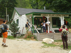
Gambier Lake 26/07/08
Dory at Gambier Lake:
“Saturday’s car free hike to Gambier Lake is definitely one of my top 5 most enjoyable hikes at Wanderung. Using 2 ferry services to get to the somewhat isolated Gambier Island, we landed at New Brighton dock at 10:15 am and started making our way up through the beautiful lush and mossy forest. The climbing portion of the hike was much longer than the organizer estimated (which caused him to give false ETA information to one of the hikers, apologies!) we reached the lake at 13:15 and spent the next hour having lunch as some brave souls went for a swim. Back at the dock at 16:45 we had enough time for refreshments at the local general store/community centre and then caught the ferry back to Langdale.”
Sumas Mountain 26/07/08
Su-Laine on Sumas Mountain:
“How does a 6-hour hike end up taking almost 9 hours? The trail to Sumas Mountain from the west is mostly well-marked, however just after the creek and before Chadsey Lake, the main trail is blocked by a fallen tree and a new trail also branches off. After inadvertently taking the new trail, which isn’t shown in the ‘103 Hikes’ book, we found ourselves walking west, not east, on a trail that looked familiar. We stopped for lunch and met some locals who confidently gave us entirely incorrect information about where we were and where we should go. More walking in the wrong direction followed, and we met the only other people we’d see on this trip, who were just as lost as we were. Eventually local pair #1 caught up with us and told us where we really should go, and we turned around yet again. The new trail, we eventually realized, forms a loop, and we weren’t the first ones to be caught in it like some space-time vortex in Star Trek: https://www.clubtread.com/sforum/topic.asp?TOPIC_ID=26394.
I was glad the group had all stuck together and gotten lost as a unit – if we’d been in this situation and missing a person, we could have been in serious trouble. I was also very grateful for everyone keeping their sense of humour! We all made it to the top, at which point we started another chapter in the annals of Lame Hiking Experiences by not being able to find either of the two summits described in ‘103 Hikes’; all we could find were microwave towers and a lookout. The lookout had a very good view of the east. ‘103’ Hikes is correct, we found, in its description of the west trailhead. It is indeed .5 km down the gravel road and very poorly marked. Wildflowers were not spectacular – I think the season for them on Sumas is pretty much over. Mosquitos, on the other hand, are still plentiful.”
Boise Trail/Tricouni Meadows 24/07/08
David in search of the Boise Trail:
“Denis and I got up extra early to do this hike because of all the unknown factors involved. Unknown trail conditions, road conditions etc. Unfortunately, the only question answered was road conditions. The Mamquam service road was blocked by a crew removing the bridge at mile 15. They didn’t seem to think that a new bridge will be in place anytime soon, so this trail will remain an enigma.
Thinking fast, we decided to cross Squamish to Tricouni meadows. The logging road was in rough shape but was no problem for my SUV. The branches are closing in though and, unfortunately, christened the SUV with scratches on both sides. I guess that it was bound to happen sometime.
The trail was wet and muddy for the first 45 minutes, At first, I cursed myself for wearing low top trail shoes, but after stepping into mid-calf deep mudholes, I was glad that I didn’t wear my boots. They only would have held more water and mud. Once past the boggy section the trail ascended to a beautiful series of alpine lakes. At the end of the second lake, someone has recently been carving a totem pole, giving the area a peaceful and surreal atmosphere. There is no official trail to the lakes but there are many paths that will get you there.
One last bit of advice. There was very little blooming in the meadows at this time. This hike will be stunning in another couple of weeks.”
Lindsay Lake 20/07/08
Maia on the Lindsay Lake loop:
“Pablo, Ilia, Jeremy, Justin, Noman, and Maia started from Buntzen Lake with with a bit of an uphill workout (1000 m elevation gain) which is then rewarded with a series of stupendous and varying lookouts showing Mount Baker, downtown Vancouver, Deep Cove, Seymour Peaks and much much more. We were very surprised to hit a number of patches of snow, but they were nicely packed and not challenging. The first little lake we hit was Jessica Lake – still half covered with ice and snow – and then Lindsay Lake. From there the way back went along gurgling little rivers and another 5 or 6 cute little lakes. The descent seemed more challenging than going up, mainly because many of us were impatiently looking forward to a dip in Buntzen Lake. After about 7 hours of rewarding hiking, the swim in the almost tepid water and the gelato at the exit of the park made us feel really spoiled. It was the first hike I organized with Wanderung and … I am going to do it again!”
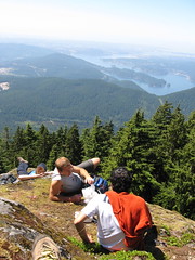
Eagle Bluffs 19/07/08
Kamen on the Eagle Bluffs trail:
“This hike was originally set up by Paul Taylor but he had to drop out because of work commitments. Three of us met at Park Royal to drive to the trailhead about 10 minutes away by car in a quiet cul-de-sac in West Vancouver. After the initial (and fairly easy) stage of the trail, the trail started climbing steeply and didn’t relent until we got to the top. The trail was fairly well-marked but quite challenging and quite a few times we had to resort to using all fours to climb some of the more rugged sections. About 2/3 of the way up, we encountered a rocky section that we had to scramble over. After a short pause on the rock field, we pushed on up to the top. We were greeted with an amazing bird’s eye view of Bowen Island, the Lower Mainland and the Sunshine Coast. The sun hid behind the clouds while we were at the top which was actually a relief. There were quite a few other people at the top who had hiked there from Black Mountain. After about an hour, we gingerly picked our way down which took almost as long as the ascent. We encountered two parties on their way up while we were hiking down; they were the only other people we encountered on the hike all day. All in all, a beautiful day for a hike with some great hiking partners.”
Hollyburn Peak 14/07/08
Diana on Hollyburn Peak:
“Our group dwindled down to 6 by the time of the hike but it was an enthusiastic group and a terrific day with a mix of sun and clouds, the perfect temperature for a short but relatively steep hike. We were surprised by the amount of snow still on the trail, probably from about 1000 m upwards, slowing down our pace a bit as we tried not to go through the edges of the melting snowmass or slip and fall. But the snow did allow us to make a miniature snowman at the summit with a banana peel wig, mini-carrot nose and wasabi peas for eyes (and yes, we did dismantle it and pack out our garbage before leaving!) The views from the summit were well worth the the slog through the snow and occasionally through scrub & brambles to avoid muddy/swampy patches on the trail, presumably wet from melting snow.”
Brandywine Mountain 13/07/08
Andrew R. on Brandywine Mountain:
“After a couple of days of re-scheduling two of us finally got out to Brandywine on Sunday. It was almost a no-go when we reached the road to the trail-head only to find it has been blocked! The new access is via the Callaghan Valley road 30 seconds further down the highway (from here you can join up with the old road). The road is in good shape and we had no trouble getting to within 700 metres of the trailhead (any truck or 4×4 could reach the trailhead proper). At a leisurely pace we reached the meadows in 1 hour 45 minutes and then continued to the north end of the meadows where we started the ascent to the summit ridge. The meadows still have a bit of snow but not as much as I was expecting and I think they will be completely clear within a week or two. After a long climb up steep snow slopes we made the summit ridge for eye-popping views of just about every mountain in the area (the stegosaurus-like Mt. Fee is especially impressive). We scrambled the ridge for a bit but stopped just short of the summit as we were running short on time. The descent from the ridge back to the meadows (650 m vertical) was one long bum-slide. 1:15 hours up… 5 minutes down! All in all a great day out with great weather and great company.”
Capilano Canyon 13/07/08
Dana in Capilano Canyon:
“Dare I say my first organized (and last-minute) hike went very well! Seven of us ventured out on a very warm Sunday morning for Capilano Canyon on the border of West and North Vancouver. Well-maintained trails led us to our first viewpoint of the granite cliffs on the east side of the canyon, and Cleveland Dam made a great place for refueling with snacks and water. Our route back took us past the fish hatchery and across a small bridge. As a short hike, not too much more to report besides the very warm weather which likely made this hike quite suitable in terms of length/difficulty. Great company and a great way to spent part of the day.”