Anna K. in Hanes Valley:
“Hanes Valley is considered a difficult hike, but the three of us were well prepared. We hit the trail at 7:45 am and finished around 6:20 pm, with 2 hour detour to Crown Mountain. Surprisingly, it took us only 6 hours to complete the boulder field. Hiking in the heat is very different. Bring at least 3 litres of water and don’t count on having water in Hanes Valley after the Lynn Creek crossing. I took advice from an article about hiking in the desert and dipped a cotton shirt in the creek and then wore it when we were under the sun. We met a lot of trail runners with small backpacks, which made us question if they are ready for a long hike in the heat. The part towards Grouse Mtn is busier, as you meet hikers from Goat Mtn and Crown, and it gets mostly shaded closer to the gondola. Overall it was a beautiful hike, with fantastic views and a great company. Special thanks to Keith for pointing out the berries and Marc for taking pictures.”
Marc’s review:
“I had a great day hike, one of the most fun hikes I’ve ever been on. The trail is filled with a variety of easy and challenging moments for an all round experience of a day hike, accompanied with the notion of spontaneity. Hiking has the three elements of trail, fitness, and company. The trail is well designed and as you hike through the Lynn Canyon Forest it’s easy to get caught up in the nature surrounding you, without noticing that you are getting higher and higher in the valley, making it for a energizing trip. At moments I found myself still and quite walking through the mountains just enjoying the a point of being in an amazing place, ‘refilling’ my cup for the week ahead, letting go of ‘pretzel’ thoughts and getting a chance for perspective. I was expecting a longer hike from all the reports and feedback I read, but without having to do the whole trail rushing experience we finished it in a good time of 9 hours, including a slight detour to Crown Mountain.
Our organizer, Anna was on the ball, making sure that we had enough water and that we reported any health concerns that we should know about. Being organized and well prepared relaxes the group and gives a sense of safety, to enjoy the experience of the trip. Water is the key ingredient, we were expected to bring 3 litres but I always bring more, I had 5 litres with me and boy was I glad, I drank every last drop. It’s true you can fill up at a couple of creeks on the way but you never know what to expect, so my advice is bring as much as you can and don’t rely too much on the creeks, it will make the trip less restrictive if you want be flexible and include another route here or there, like we did. It was quickly established that Keith was willing to sacrifice his calves if we ran out of food, Anna was planning to peel her hands off the hot boulders and dry ice to relieve the swelling and I was hoping my boot soles would not fall off.
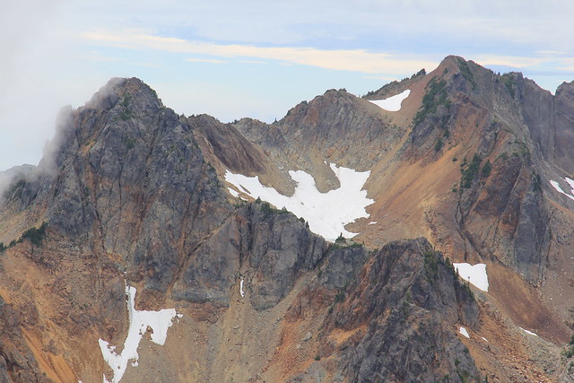
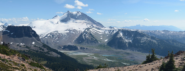
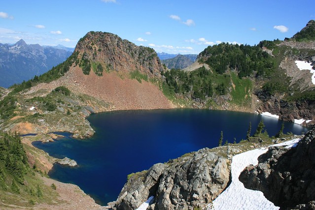
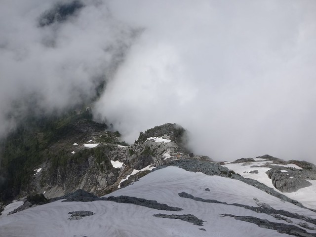
Not knowing what to expect I wanted to prepare to bushwhack in find the route, using the trail map and google, I found the UTP coordinates of some of the markers on the route, but never had to use it. There are moment while hiking that you could find yourself in a little ‘break path’, while looking down, this happened once to use between Hanes Valley Junction and the helipad, so try keep your head up for the next marker. We ended up deciding to bushwhack up the mounting, the trail was less than 20 m from us. I found that the markers were a little old but still good, for this time of year, if it was late, raining or foggy things could have felt a little different. The views are breathtaking and worth every step, there is something that ‘clicks’ when you sitting on top of the mountain and everything lies beneath you at your feel, the heights are glorious and the feeling of tipping into the abyss of space hangs with you in the air. After 5.5 hours of hiking we reached the top of the boulder field in good health and the two of us, Keith and me decided to ascended Crown Mountain. It was a 2 hour detour that we thought was going to be shorter. I’m really glad that we got to do Crown Mountain, it was the hardest part of the hike and I would recommend you do it as the cherry on the top. Coming back felt longer than thought it would be, taking us another 2 hours. Ending the trip at Grouse Mountain was fun, being able to see the bears we were ever aware of and taking in the view from the gondola with a cool drink at hand was a perfect finish. I think doing the hike the in the other direction might be even more fun as you could finish up with a swim in the lake, granted you have a picnic basket filled cool cold drinks. The most dangerous part of the trip was riding back to the Lynn Canyon parking lot, there were moments that I saw my life flash before my eyes, but we made it safe.
There were a lot of trail runners passing us, with very little preparation, hopefully they know the route, but we did bump into a fellow that was doing it for the fist time with no essential gear, fortunately for him it was still very early in the day and there were running creeks not too far. It’s not a hike I would like to take my grandpa on, people need to be in good shape to complete the route. The topic of cramps came up a couple of times and I would suggest that people look into a plan of managing their cramps if they find themselves in this situation, lots of water, protein bars and hydrates are essential, specially if you not in great shape.
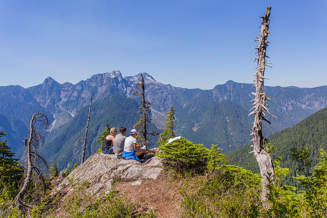
I really liked that we had a small company of 3, four would be fine but I find when there are more than four people the whole dynamic changes. Being a smaller group allowed us to give each other more attention and share our conversations with the entire group while walking. Keith in his own right is the joker of the group, he was full of fun and surprises around every corner keeping us on our toes. Anna was always very considerate and entertaining us with all her previous hiking stories, I was more reserved than the others, laughing at all the playful puns and quirks.
I’m really happy that the day went so well, if I could repeat it I would do it in a flash but every trip has is own unique experience and this was one that will be remembered for a very long time.”
Marc’s photos