All posts by andy

Kennedy Falls, 2 Apr 2016

Bob H. at Kennedy Falls:
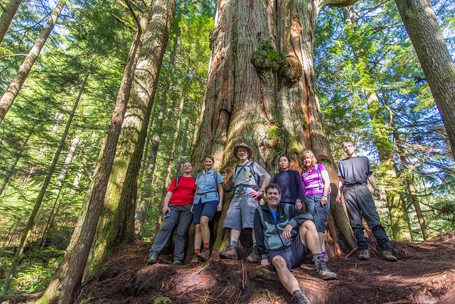
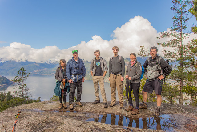
“This is a great hike with two points of interest. First, is the big cedar tree, which has been estimated at over 600 years old; the second is Kennedy Falls. Don’t let the length and elevation gain of 170 m fool you for this hike. There are many ups and downs on this trail making the cumulative elevation gain 750 m. The length of the trail is 5 km, so the return total is 10 km. The trail traverses the west slope of Lynn Valley and you will find the big cedar tree 3.3 km from the start; also of note – the big cedar tree is less than 100 m from Lynn Creek. The cedar tree is massive and the only reason I think why it was spared from the saw in the early 1900s, when the whole area was logged, is that there was no saw large enough! The end of the trail marks Kennedy Falls, which is spectacular and fills the air with wind, mist and rainbows. There is a new parking lot at the trailhead on Mountain Highway, which fills up fast, so get there early. This is a very popular mountain biking area.

Blog post here: http://www.buntzenlake.ca/big-cedar-trail-and-kennedy-falls

Full Flickr photo album of hike here: https://flic.kr/s/aHskxGD5Pg

Group at the big cedar tree

Eagle Bluffs, 28 Mar 2016

Colleen C. at Eagle Bluffs:
“Glorious day to be on a mountain – spring is certainly upon us!

The air was cool through the forest on the way up, keeping the sweat at bay, but was balmy on top. No biting bugs out yet so we basked comfortably in the sun enjoying the views of the tankers, islands, ferries, and several eagles & ravens gliding in the thermals. Lots of grouse are out, and we saw a snail!

There were only tiny patches of snow in a few sheltered spots at the bluffs (just enough for snowballs but you had to work at it). We met one person who had come from the Cypress side, she reported little snow and just wore boots. That said, there are recent reports of heavy snow on other North Shore peaks, so do your best to get current info and be prepared. Spring can be capricious!

This was my first time doing this hike by transit and it worked out well. Take the 250 or 257 to the overpass just before descending into Horseshoe Bay. From there it’s a careful crossing of Horseshoe Bay Dr and short walk back to the Black Mountain trailhead.”

Upper Shannon Falls, 25 Mar 2016

Bob H. at Upper Shannon Falls:
“With a forecast all week for sun for Friday, expectations were high. A little concern about 5 mins from the parking lot, when it rained slightly, but the clouds parted and we were treated with lots of sun today.

Upper Shannon Falls is the 3rd highest waterfall in British Columbia and the hike to the top is well worth it. Today, our group of six parked in the Shannon Falls parking lot, but you can also park in the parking lot for the Sea to Sky Gondola, a short distance to the north. The initial part of the trail is shared with the trail for the Stawamus Chief hike. If you park in the Shannon Falls parking lot, you can see the bottom of the falls before your ascent. The trail is well maintained by BC Parks and there a few bridges to cross. Sections of the trail are steep, with some parts having nicely placed cobbles for steps. The trail was quite busy today and there were about 30 people at the top viewpoint.

The trail rises steeply and there are a couple of viewpoints before the top. There is also a section of the falls, where you can get very close. There is also a nice pool of water in the creek, where you could go in – in the summer, but I would imagine the water is very cold all year. At the top, you are rewarded with an amazing view of the end of Howe Sound, the Stawamus Chief and Squamish. The bluff at the top is a large area and accommodates several people.

Overall, the day turned out perfect and the group really enjoyed the hike.

Blog post here: http://www.buntzenlake.ca/upper-shannon-falls/

Full Flickr photo album of hike here: https://flic.kr/s/aHsktHWSzp

Group at the top

Phyllis and Marion Lakes, 13 Mar 2016

Chris N. at Phyllis and Marion Lakes:
“We had a full compliment of hikers for this not-very-spectacular destination (organizers: there is a thirst for hikes so do some callouts!). We parked just at the base of the Phyllis Creek road just north of the Furry Creek golf course. The yellow gate at the bottom of the road was locked and, if open, can’t be trusted to be so when you return so don’t drive through it. ATVs have build an elaborate route around the gate and we encountered 2 ATVs. Also met 2 trucks out exploring (not sure how they got up there).

I usually use iMapBC to create detailed 1:20000 maps but I am starting to encounter issues with the age of some of the road data. This trip highlighted those issues. We encountered several recent forks that just weren’t on iMapBC and difficult to see on Google Earth. There’s a triple fork around 1 km – take the leftmost road. After crossing Phyllis Creek, there are new roads on the right in several places and signs warn of active logging.

The lakes themselves are not much to look at but rocky bluffs straight out of an old Chinese print loomed over them and were pretty cool. The second lake has a dodgy makeshift dock. It took just 2 hours to reach a large fence and gate blocking access into the Capilano watershed just past the lakes (I am sure you could get around it if you really wanted to). We had a quick lunch in some wet snow and headed back just as it started to rain. Got some good use our of our waterproof clothing. We were back at the cars in time to drive the short distance to Galileo’s Coffee in Britannia Beach before they closed (3 pm during the winter).”

Kennedy Falls, 12 Mar 2016

Paul G. at Kennedy Falls:
“A wet day with a little hail thrown in for effect, but a nice hike regardless. Trail conditions this time of year are slightly muddy, but even with our recent rainy weather, no one seemed to have trouble with the stream crossings. There were a few downed trees, but easy to get around. If you are not familiar with the route, keep your eyes on the few markers. It’s easy to get down a dead end when you are deep in conversation. Besides the beautiful big cedar, Kennedy Falls at the end of the trail was spectacular. For a trail that was relatively unknown a few years ago, it was busy with trail runners early on and hikers later. Popularity due in part by the addition of the new parking lot last year.”

Crossing

Mt Seymour, 20 Feb 2016

Chris N. on Mt Seymour:
“The weather was exactly as predicted but the snow conditions were better than I had anticipated. We arrived at the Mt Seymour parking area about 10 am and parked across from the tubing area. The temperature was about freezing and we were treated to about 1/2 hour of light ice pellets before the precipitation stopped. There’s about 1 m of snow at the parking area but over 2 m less than 1 km up the trail. The snow below Brockton Point was heavy and sticky but much nicer past this point. Snowshoes would be advised beyond Brockton Point to prevent postholing. Avalanche conditions were listed as moderate below treeline and considerable at treeline. It was quite foggy at Pump Peak with visibility dipping to about 50 m at times and very flat light. After a lunch stop, we continued on to Second Peak following some ski tracks to the base of the gulley (no snowshoers had ventured further than the first peak that day). The ice pellets rolled underfoot and slowed our accent. The sun peeked out on our descent and provided some really nice lighting.”

Lower Mt Fromme trails, 13 Feb 2016

Chris N. exploring the lower Mt Fromme trail network:
“The trail system on Fromme is a true rabbit warren. Even with 2 sets of detailed maps, it often took time to figure out where we were. Besides named trails, there are many minor trails. Signs are infrequent and only on the Baden Powell and Mountain Highway. We started at an unsigned trailhead beneath the power lines at Braemar Road. If you are driving, there is good street parking on the north side of the road here. Otherwise, the 230 bus travels this road. We hiked up Dreamweaver almost as far as the crossing over Mosquito Creek. We then backtracked a bit to Peer Gynt (unsigned) and climbed to the Mountain Highway which we hiked down until we got to Pink Starfish. This is a double-black bike trail but it doesn’t seem to get much traffic these days. We actually lost the trail about halfway down and followed a minor trail down to an old skid road. Going east on the road for a bit, we found Pink Starfish again. We continued east as far as Espresso which we followed to St Mary’s trail. Back along St Mary’s to Boundary and this we followed until we came out at our trailhead again. We found two old cabins on our explorations but both are in the last stages of collapse.”

Eagle Bluffs, 7 Feb 2016

Colleen C. at Eagle Bluffs:
“Maybe it’s because I’ve spent a lot of time lately in snowy mountains, but the greens of the forest here seemed particularly vibrant.

We did, quite suddenly, hit snow at about 750 m (where the boulder fields start). We continued up another 50 m or so but it was a bit of a slog moving up through knee-deep moist snow on top of loose rocks so we found a lunch spot (nice views of Horseshoe Bay and the islands) and then headed back down.

We ended up driving (thanks Susanne!) but this is a good transit hike.”

Deroche Mountain, 31 Jan 2016

Colleen C. on Deroche Mountain:
“Four snowshoers
Eight cookies
Fifty-four waterbars
Two lakes
Wait, how many waterbars?!

Yes, that’s right FIFTY-FOUR waterbars on this hike! I’ve never seen so many or some so deep on a relatively short stretch of logging road – and as a born and raised BCer, I’ve seen a lot of waterbars in my life.

I’d been warned about these so-called “monster waterbars” but brushed it off as an exaggeration by folks who perhaps didn’t have much experience about how BC deactivates its logging roads. Well, crow eaten. And let me tell you that’s tough for a crow admiring vegetarian.

That said, I perversely found it great fun, both climbing through them and counting them on the way back. We didn’t make the summit so I’ll be re-visiting this area soon. If anyone happens to go before I can get back, let me know your waterbar count (in my astoundedness maybe I miscounted one or two). Though I’d recommend waiting for a bit more snow or a rather a lot less.

The snow conditions may have made some more tricky than usual, but for this I defined a “waterbar” as a distinct, steep down & up all along the length of the Hanson Creek road. Some were natural creek washouts,
rather than dug out by a mad excavator operator futilely but energetically trying to dig a tunnel to China, but not many.

Cypress Creek, 20 Jan 2016

Jaime A. at Cypress Creek:
“Seven of us headed up to do some snowshoeing on Cypress, led by the fantastic Perry. This was a well-timed trip because the pineapple express hit the next day and ruined all things snow in the North Shore Mountains. The plan was to start on the Baden Powell trail that begins just in behind the first aid hut, cross Cypress Creek and head uphill to have lunch somewhere on the saddle between Hollyburn and Strachan. We headed into the trees and onto some very sucky snow.

The past week’s wet snow/rain had turned anything under the trees into an ugly crust. The spaces pocketed between the trees had soft snow and they were a nice break. It was an awkward mix that was too hard for snowshoes but too fragile a crust for microspikes (we had some hip-deep postholes). Once out of the forest we were all pretty excited about the surreal thickness of the fog, obscuring all but the closest trees, and the perfect snowshoeing conditions of the snow.

We were able to practice our MacGyver skills as we ended up with 2 broken snowshoes and a broken pole along the way, all of which were remedied by some fine teamwork and “10 essentials” supplies.

On the way home we helped dig and push a young fella and his tiny, fancy car (with summer tires) out of the snow that thankfully stopped him 4 feet from a steep plummet down a ravine.

A great trip with a fantastic group of adventurers!”