All posts by andy

Mount Price, 13 Aug 2016

Will B. on Mt Price:
“Four of us left Rubble Creek parking lot at about 9 am on Saturday to hike Mount Price. Up to Garibaldi Lake it was teeming, but after leaving the lake we saw a total of four other people. The trail winds through trees and over bouldery bits with occasional lovely views of the lake or the Tantalus mountains on the other side, until you reach the start of the real climb, which was steep, loose and very hot. At this point I was like a big sweaty snail. The views on top were amazing, especially of Mount Garibaldi itself. It took us 11 hours all in. Brilliant hike and a great group of hikers made it even better.”

Table and Garibaldi

Chipmunk and Tenquille Mountains, 6-7 Aug 2016

Chris M. at Chipmunk and Tenquille Mountains:
“Dean and Quirine joined me for an overnighter northwest of Pemberton. From Pemberton you travel West along the Pemberton Valley, cross the river, head up the Hurley and finally on to the Hope Creek Road FSR. This logging road is easy. A 2wd car could make it as far as I could; which is about 2 km from the road end.

There is a faint route through the trees that is well-flagged. Until you cross the creek. After that you have to find your own way but the bushwhacking wasn’t too hard. We reached our camping spot at Opal Lake in about 2 hours.

Saturday afternoon we scrambled up Tenquille Mountain. (Dean also went over and bagged Goat Peak). The weather was perfect. The views were lovely. The flowery sections were blooming. Instead of star-gazing during the night we all stayed in our tents, as we were entertained by the sounds of rolling thunder and intermittent rain.

By the morning the storm had passed and we decided it was nice enough to hike up another mountain. We were standing on the summit of Chipmunk Peak less than 2 hours later. On the way down we passed through many wonderful meadows full of flowers. All different colours of flowers. In one section the flowers were up to hip high!

The bugs didn’t want us to sit down and enjoy them however, so we marched back to camp and packed up. During the hike out we saw two moose. Everyone enjoyed changing into clean clothes once back at the car. Along the road we saw a deer and a bear.

We each had a different delicious burger at Mile One. It was very nice to split the driving duties as the drive from parking spot to Burnaby was 250 km.”

Iceberg Lake, 6 Aug 2016

Eugene Y. at Iceberg Lake:
“Seven of us went to explore the new Skywalk Trail system near Whistler. We started from Mountain View Drive and proceeded at a relaxed pace along the 19 Mile Creek trail. This well-maintained trail was a joy to follow as it was well-graded and featured numerous bridges and boardwalks. We gradually ascended through a pleasant forest toward the alpine area at the eastern slopes of the Rainbow Mountain. After hiking for about 3 hours, we reached the junction with the Skywalk Trail and then continued for another kilometre along the Skywalk North trail till we finally arrived at Iceberg Lake. This picturesque turquoise lake is located right underneath the Rainbow Mountain glacier. As the name suggests, the lake was partially covered by floating ice. We spent the rest of the afternoon relaxing at the lake, taking pictures, and exploring the slopes to the south of the lake.

Bugs were quite bad at the alpine portion of the trail. Also, some of us got stung into the legs by wasps at two separate location: near the big yellow sign about the trail crossing a bike path (about 20 min into the hike), and at another location closer to the alpine. If you take this trail this August, it’s a good idea to wear long pants. Hopefully, wasps won’t return next year, once the trail becomes more popular.

Thank you for all the volunteers for building and maintaining such a great trail!”

Iceberg Lake

Mt Macfarlane, 1 Aug 2016

Eugene Y. on Mt Macfarlane
“Three of us embarked on a trip to the beautiful alpine lakes at Mt Macfarlane. The trail was in a fairly good condition, although some portions were really steep and required some care. Hiking poles are strongly advised, especially when passing above the first lake. It took us about 4.5 hours to reach Upper Pierce Lake. As some of us felt really tired, we decided not to proceed further and took a long break at the beach. Some of us went to explore the area at the ridge right above the lake in order to catch views of the surrounding mountains: Crossover Peaks, Slesse Mountain, Illusion Peaks, Mt Rexford, etc. There was very little snow in the area, just patches here and there, however, the trail toward the peak has some steep scrambling sections and can be quite slippery.

On the way down we briefly stopped at the first lake and some of us took a swim. It took us about 2 hours to get from Lower Pierce Lake back to the parking lot.

Overall, this was a fairly demanding hike for a day. It would be interesting to revisit the area on an overnight trip in order to appreciate the true beauty of the lake in early morning hours.”

Upper Pierce Lake

Mt Harvey, 23 Jul 2016

Erin P. on Mt Harvey:
“Three of us tackled Mt. Harvey on Saturday. We arrived in Lions Bay to find the meagre 5 or 6 parking spots at the trailhead already taken. However, I was pleasantly surprised to find there are actually quite a few parking spots around the village without the dreaded tow-away signs. Do be careful not to block driveways, etc.

This trail has a well-deserved reputation for being relentlessly steep. We powered up at a good pace, grateful for the cooler weather. Near the top, the bugs were out in full force, and we wondered – what can they possibly eat when there are no hikers? I would bring bug spray if doing any of the Lions Bay hikes in the near future.

After lunch near the summit we headed down, enjoying the views of Howe Sound on the way. Despite the many cars in the village, we only met 3 other parties on the trail. Our total time was about 6.5 hours. Thank you Eugene and Laurel for joining me on my first callout!”

Golden Ears, 16 Jul 2016

Eugene Y. on Golden Ears:
“This route has a well-deserved reputation of a most challenging trail in the Lower Mainland. The trip felt much longer than 24 km, as it also involved almost 2 km of cumulative elevation gain (according to our GPS). Traveling at a brisk pace, we made it to the peak in 5.5 hours, however, the return trip took us well over 6 hours, as some parts of the trail were quite slippery. The steep middle portion of the trail was particularly sketchy on the descent; it would definitely benefit from some additional foot steps and permanent chains or ropes.

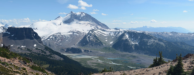
Panorama Ridge below the shelter was mostly snow-free, however we had to cross a large snow field on the way to the peak. The condition of the snow varied. An overnight hiker told us that it was somewhat icy in the morning hours. However, the snow got softer by midday, even though it would still require some efforts to make foot steps. We had to carefully navigate the snow field in order to avoid the steeper portions. Even though we’ve seen a few groups having made it to the top without crampons, many of us were really happy to wear microspikes.

Trekking poles (or even an ice axe) are really needed on this snow field. In fact, even with snow poles, some of us found it difficult to perform a controlled descent. Using poles for stopping yourself while sliding definitely requires some practice; moreover, poles can easily bend or even break if not held properly, as some of us discovered.

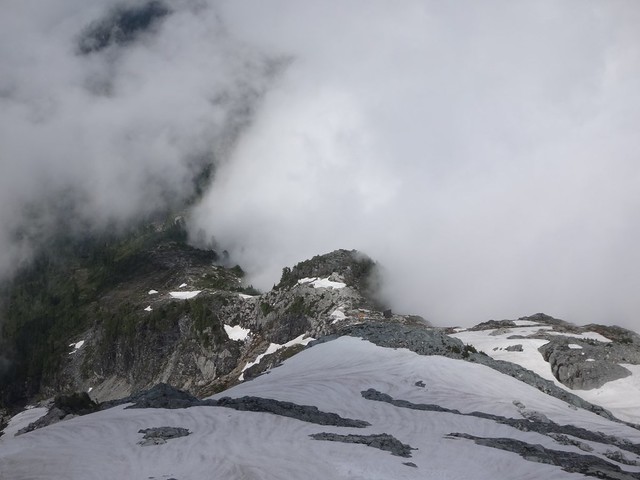
The final scramble to the top was, perhaps, the most enjoyable part of the route. We were lucky to get some really dramatic views through the fog.

Overall, this was quite an epic trip with a wonderful group of people.”

View from Golden Ears peak

Southern Chilcotins, 30 Jun 2016

Chris N. in the Southern Chilcotins:
“Matt, Doug and I spent 4 days camped in Graveyard Valley in the Southern Chilcotins and exploring the surrounding ridges. Access was via the Hurley (thoroughly unpleasant but 2wd-able), the Tyaughton Lake road (washboard-y corners but 2wd), Taylor-Mud Connector (slick when wet descending to the Tyaughton Creek crossing but 2wd otherwise), Mud Creek FSR (excellent; very 2wd), Mud-Paradise FSR (one berm 2/3 of the way down the hill to Tyaughton Creek might be 2wd; pothole-y after hill but reportable 2wd beyond the Tyaughton Creek trailheads) and the Relay Creek FSR (totally not 2wd right from the start). The last road requires high clearance 4wd and lots of nerves. There’s channeling, creek crossings, deep rutting, mudpits, off-camber sections with exposure and one steep off-camber hill with bad traction. We spent 1/2 hour doing some road work (bring shovels!) and made it to the road end. But this road isn’t going to last many more years. Once on the trail, they are generally easy to follow but wet at this time of year. We spent most of our time off-trail up in the alpine though and encountered very little snow – even above 2500 m. Deer, wolf, bear and moose tracks abound. Saw a sow grizzly with 3 yearly cubs and a wolf. And met no-one else. An excellent trip to my favourite part of the province.”

Flower Forest

Skyline Divide, 26 Jun 2016

Phil A. on Skyline Divide:
“Mount Baker beckoned, and four Wanderungers answered the call with a perfect day hike along the Skyline Divide. After navigating the pockmarked road (low clearance cars beware), we set out through the woods. 450 m later we popped out into flower-peppered, emerald green, and a snow covered ridge line. From there, it was one spectacular view after the another, and an afternoon of hiking, laughing, and bum sliding. The ridge that runs towards Mount Baker seemed to go on forever, and a wise Wanderunger would do well to bring a tent to spend at least one night atop one of its numerous knolls. Sad that we couldn’t overnight, we turned back and headed to Sumas for some Mexican food.

Elevation Gain/Loss: 1200 m/-1200 m
Distance: 13.5 km (most of the trail is easy to follow, but some parts are still snow-covered).
Time: At a slow/moderate pace you can reach the ridge line in 1.5 hours. After that, you can go as far as you want. We went as far as N48° 50.527′ W121° 51.464′ before turning around.”

https://www.instagram.com/p/BHJjwFrAe3c/

Flora Peak, 25 Jun 2016

Phil A. on Flora Peak:
“Confident that the weather would clear up, your heroes set off to conquer Flora Peak in Chilliwack Lake Provincial Park. The hike was a good mix of mossy second-growth forest, alpine meadows, talus slope-scrambling, and ridge exploring. We also timed it perfectly, and the clouds parted as we reached to summit. No real snow except for a few north-facing patches. Rather than take the trail down, we ‘shwacked through the flower fields and got a fantastic view of Chilliwack Lake.

Elevation Gain/Loss: 1520 m/-1520 m
Distance: 12.7 km”

https://www.instagram.com/p/BHGrxn5A1Ki/

Slollicum Peak, 4 Jun 2016

Phil on Slollicum Peak:

“In search of a snowy summit on a scorching day, four intrepid Wanderung-ers headed to Slollicum Peak. After muscling our 4×4 up to the trailhead, it was a 4-hour hike on a moderately well marked trail. We were greeted with blooming flowers, the odd stinging nettle, and babbling brooks. The summit was snow covered, and offered a great 360 degree view of the hanging Slollicum Lake, Mt Baker, Harrison Lake, and the countless surrounding peaks.

Distance: 13 km
Elevation Gain: 1440 m
More hike information on Club Tread

https://www.instagram.com/p/BGSCveWtuJE/