
Astrid M. at the Mount Baker region
“The weather Gods were with us this weekend and we enjoyed the rich variety of trails and landscapes in the Mt. Baker-Snoqualmie National Forest. Following the Ranger’s tip, we went to Hannigan Peak on Saturday which is an open trail through a nice valley leading up to the peak with stunning 360 degree views. Snow started at about 1300m but did not pose much of an obstacle. After a cozy night in a cabin we set out to hike the Ptarmigan Ridge on Sunday. The road is closed beyond Heather Meadows where Picture Lake is located which means some extra work to get to Artist Point were the trail starts. The parking lot at Artist Point was already covered in snow. The views from the trail are spectacular with Mt. Baker constantly in view. Some parts of the trail after the junction with the Chain Lakes trail were frozen solid with a thick layer of ice. We did not make it all the way to the Coleman Pinnacle but opted for an earlier return in order to take the Chain Lakes trail back to the parking lot. We were rewarded for that decision with more amazing views of lakes, meadows, alpine landscape and snowy mountains. Thanks a lot to the group for being flexible with making route decision. I believe we all had a great time.”
Category Archives: Multi-day
Grand Canyon 25/09/08
Sue in the Grand Canyon:
“The 3 of us started out at sunrise down the North Kaibab Trail taking the side trip to Roaring Springs to cool off in the water. Ribbon Falls was the highlight of the first day after setting up camp at Cottonwood and playing in the creek. Setting off at daybreak again on day 2 got us to Bright Angel campground well before lunch with time to relax at Boat Beach before hiking the River Trail loop for more fabulous views. On our layover day we hiked almost half of the 9 mile Clear Creek trail, a very hot trail even on a day with some cloud cover. Lots of sun exposure and great views from this trail. After lunch Ribeka and Lucy also visited the waterfall at Phantom Creek and did a very worthwhile exploration further up the creek. Wildlife included 2 rattlesnake encounters and 1 sighting. Scorpions and a black widow spider were revealed by Ranger Pam at one of her several informative talks at Phantom Ranch. Great weather with t-shirts for all except the first hour from the North Rim and very warm nights. Hiking out the Bright Angel Trail for the first 2 hours with headlamps allowed Lucy and Ribeka to venture quickly out on the side trail to Plateau Point for sunrise before the final 5 mile uphill stretch. Early rising was worth it to avoid the extreme heat of the day. A 4am start got us up to the South Rim well before 11am hiking in almost total shade. Lots of chit chat with the many tourists on the upper section of the trail. We were reportedly the only hikers with smiles on our faces at that point and we were sad to have the trip coming to an end so soon. A great trip and couldn’t wish for better company. You can’t help but love the Grand Canyon for all its fabulous expansive views every step of the way. I expect we will all be back to explore more trails here in the future.”

Stein Valley mini traverse 30/08/08
Merewyn in the Stein Valley:
“Pictographs, cable cars, unlogged old growth forests, a beautiful clear river – the Stein Valley has it all and more! Andy, Maria, Christian, and I spent a wonderful week traversing the Stein from Blowdown Pass to Lytton. The trip started out with intense snow flurries at Blowdown but once we got over the pass and down into the valley we had great weather. We saw no large wildlife but we did see lots of squirrels, mice, ant lions, lizards, and snakes. In fact, we saw as many snakes as we saw people – once we left the Pass, we only saw 8 other people and had every single campsite to ourselves. The section between Blowdown and the Stein is obviously very under-traveled as we saw no other hikers and counted 76 trees blocking the trail within an 8 km stretch. The main Stein trail was infinitely more maintained. An unforgettable area!”
![Stein Valley - Thurs, 04.Sep [Day 6]](https://farm4.static.flickr.com/3255/2836686687_f580a76934_m.jpg)
Athelney Pass 30/08/08
Chris at Athelney Pass/Salal Creek:
“Attrition due to injuries and work commitments whittled our group down to just 2 but off we went anyway. The Lillooet River FSR is in good 2wd condition all the way to the Salal Creek Road. A creek was flowing over the road at 45.5 km which is probably doable by a confident driver in a 2wd with average clearance but depends on the time of year (earlier = higher water level). The hill beyond had a bumpy bit at the start but was good after that. At the top of the hill is the unmarked Salal Creek Road on the right (47.8 km). Most of the traffic on this road takes a right fork at 1.1 km to go to a mine – the route to the trail is straight over a shallow berm (may require high clearance). Two-wheel-drive traffic will be halted by the heavy rutting caused by water runoff at 1.3 km. We turn left at 5.3 km (straight leads to a new cut) and arrived at the trailhead at 6.0 km. The trail started at the far (north) end of the cut and is flagged by orange and pink flags (some initial confusion due to 2 parallel sets of flagging 10m apart – the best set is the uphill ones). A distinct footpath is rare but the flagging was good even in dense slide paths. Half an hour later we emerged on the gravel flats next to the creek. Whenever the creek hugged the east bank, flags led up into the forest to bypass the section (keep an eye peeled for them). There was one unflagged section of alder travel (100 m but felt much longer). Nearing the glaciers and after the recent rockslide, a faint footpath appeared close to the creek but disappeared after the first side-creek crossing. The 2 creek crossings are unbridged but we rock-hopped over them after scouting for a good crossing point. After that, the route traveled along a glacial moraine until it got too eroded and knife-edgy and we were forced down to the creek again. Much rock travel took us to the volcanic flats from where it was less than an hour to the collapsed cabin at the pass. Over the next couple days, it snowed, our boots froze solid, we visited ice caves at the toe of Athelstan Glacier, travelled down the boggy McPharlon Creek and climbed the Elephant.”
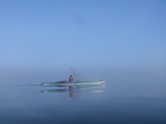
Johnstone Strait Kayak Tour 16/08/08
Sandra kayaking the Johnstone Strait / Broughton Archipelago:
“Our group of 8 headed out for a great 6-days on the water around both the Johnstone Strait south of Telegraph Cove and north through the Broughton Archipelago (as far north as Insect Island and Echo Bay). We got a little of everything… Half the time there was beautiful sunshine but we also had a day of rain. The winds picked up for sections of our days (including one “exciting” crossing with waves from both current/wind, and also from the wake of a cruise ship!) but we also had wonderfully calm days. Campsites ranged from amazing island set ups with wooden structure outlines ready for tarps & tree swings to simple clearings in the woods. We had lazy easy days and a couple long paddle days.
Highlights from the trip included seeing porpoises everyday, orcas half the days, visiting First Nation reserves / abandoned communities, campfires every night, amazing food, freezing dips in the ocean (did I mention the WARM campfires?!?!), navigation practice during early morning fogged-in paddles & hunting down camping areas amongst the islands and the distance we got from the crowds of Johnstone Strait. Good times on and off the water!”
Johnstone Strait 09/08/08
Sandra kayaking in the Johnstone Strait and Broughton archipelago:
“Our group of 8 headed out for a great 6-days on the water around both the Johnstone Strait south of Telegraph Cove and north through the Broughton Archipelago (as far north as Insect Island and Echo Bay). We got a little of everything… Half the time there was beautiful sunshine but we also had a day of rain. The winds picked up for sections of our days (including one “exciting” crossing with waves from both current/wind, and also from the wake of a cruise ship!) but we also had wonderfully calm days. Campsites ranged from amazing island set ups with wooden structure outlines ready for tarps & tree swings to simple clearings in the woods. We had lazy easy days and a couple long paddle days.
Highlights from the trip included seeing porpoises everyday, orcas half the days, visiting First Nation reserves/abandoned communities, campfires every night, amazing food, freezing dips in the ocean (did I mention the WARM campfires?!?!), navigation practice during early morning fogged-in paddles & hunting down camping areas amongst the islands and the distance we got from the crowds of Johnstone Strait. Good times on and off the water!
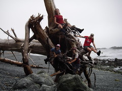
North Coast Trail 02/08/08
Sandra on the North Coast Trail:
“What an amazing week our group of 11 had on the 1-way 80 km trip through the newly opened North Coast trail and tried-and-true Cape Scott trail. We lucked out with only a few hours of light rain on 1 of our 7 days on the trail (4½ days on the NCT, 2½ days on Cape Scott, 2 travel days). There was lots of wildlife, with everything from bears and gray whales to a couple of porpoises playing around the front of our boat for 10 minutes during the water taxi ride on day 1 (and don’t get me started on the “whale-bear”).
Since we decided to hike the North Coast trail heading west, ending up on the Cape Scott trail, we did a 3 hour car shuffle at the end of day 0 to leave a couple vehicles in the Cape Scott parking lot (our end point). Our first day on the trail started with an hour-long water taxi ride from Port Hardy.
What was in store for us on the North Coast trail was apparent right away – straight off the rocks where the water taxi dropped us off, we had to haul ourselves up a steep embankment into the forest with the help of ropes. And – this was only the “moderate” section! The “very difficult” sections were great… ahh… for team building?!? Lots of muddy bluffs had to be scaled or descended with the use of ropes. The group did a fantastic job of yelling tips at people hanging from ropes on where to put their feet, passing backpacks along when sections were easier done as a pack-free scramble, hand-holding across sketchy sections, and of course taking pictures when people fell off the trail before helping them up (only after checking that it was just pride that was hurt, of course!).
I now have a new appreciation for the fact that a “minimal elevation gain” hike can be harder than summiting a peak! The NCT is a fantastic trail for anyone who wants to experience coastal hiking / loved the West Coast Trail, but wants a bit more challenge and no crowds. Kudos go to the folks that have punched this new trail through!!”
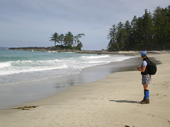
Cape Scott 31/07/08
Carollyne at Cape Scott:
“Charlie, Curt, Lucy, Ribeka and I caught the 8:30 am ferry to Nanaimo for a rainy drive and dinner at The Scarlet Ibis in Holberg, before beginning the muddy trek to Eric Lake at 7:30 pm. It was hard to imagine what a `muddy trail’ meant before Cape Scott, but we were all glad we brought gaiters. Fortunately, Thursday night saw the last of the rain. Friday, we hiked out on the waterlogged, but lovely forest trail giant spruce, stunted pines moss, ferns and the largest skunk cabbage I’ve ever seen – over boardwalks, bridges and mud to Nels Bight beach in bright sunshine, quickly throwing off our boots for a run into the ocean. Amy, another Wanderunger and a friend were there to greet us. That evening we sighted 3 grey whales blowing and fluking for several hours before having our first amazing 3-course dinner and sharing Amy’s campfire. We had heavy packs, but great food. Saturday, we day hiked to Experiment Bay, Guise Bay and the lighthouse, enjoying brilliant sunshine, stunning beaches, end of the earth views and interesting chats with the lighthouse keeper before another evening of whale sightings. Sunday, we were relieved to have a somewhat drier trail for the 18 km trek to San Josef Bay. While on the trail, the writer lept over a mudhole a little too recklessly, resulting in a full body and face plant in the mud with Curt at a full run in rescue. Luckily, a good laugh was the only consequence. Monday, some of us enjoyed San Josef Bay’s beaches, sea stacks and heat while others hiked to the cold chill and clouds of Mt. St. Patrick. Another starry sky, a great dinner and campfire filled our last night at Cape Scott. Everyone contributed cheer, great conversation and teamwork to make this a fantastic trip. Curt gets special thanks for helping get our packs on our backs and all the driving too. Sorry that Daniel was held up at work at the last minute so couldn’t make the trip.”
Southern Chilcotins 29/07/08
Chris on Slim/Gun/Taseko in the Southern Chilcotins:
“Dean had to drop out so that left just Cara and I for a week in a quiet corner of the Southern Chilcotins. The Hurley road was in great condition earlier this year but is deteriorating – still drivable at speed but bumpy, pot-holey and washboardy. Slim Creek FSR was great until Jewel Bridge but only OK 2wd after that until the blocked bridge at 28.5km. An hour of walking took us to the end of the road and the start of the very wet trail (no way to keep your feet dry on this one). Soon we left the trail and spent the rest of the trip off-trail wandering the alpine or bushwhacking for days. Despite less-than-stellar weather (rain/hail/snow every alternate day), a scaled-back itinerary (20km of off-trail travel a day is insane) and a tent fly that was a sheet of ice on the last morning, we had an amazing time. No bears or wolves (there were plenty around given the number of prints we found) but we did have close encounters with a bull moose and a porcupine. We found 40 year old mineral claim posts and animal bones, gazed down on massive glaciers, glissaded snow slopes, forded icy streams, strolled meadows that extended forever and saw no-one (except the helicopter pilot who buzzed us one morning). Days of rain followed by a beautiful sunny day resulted in a hatch of mosquitoes of biblical proportions which turned our bushwhack back to the trail on the last day an epic of endurance. It’s a beautiful place and I’m already planning a trip (or 2) back.”
Horne Lake 25/07/08
Greg on a Horne Lake adventure:
“The trip this weekend went without a hitch. Thirteen of us made it to the campground where we enjoyed the teepees, although one was a bit drier than the other due to heavy rains Friday night. The group enjoyed a restful stay and bountiful meals in the beautiful, clear scenery of Horne Lake. Some hiked, some caved, some played frisbee, and some even skinny-dipped. All of the people on the trip were of great interest: professionals with various backgrounds and common values made for some interesting conversation and classic good camping and outdoor recreation. If I hadn’t left my camera on the roof of a stranger’s car, I’d have documented proof.”