
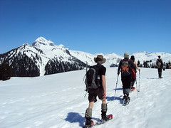
Steve at Widgeon Lake:
“Amazingly, there was still 5-10 ft of snow at the top of this trail (but only at the very top strangely). The journey was far tougher than we expected. Painful boat logistics. An almost not seaworthy inflatable boat for 2 people. A steep slippery root climb for last 2 km. Rain for 70% of it including the chilly snow camping. Even then Widgeon lake is worth a revisit. Though we could barely make out a view, I suspect that the lake islands and granite backdrop would be spectacular. As it was the ice was very interesting (very arctic like). Do this one at the end of the summer when it is dry and make sure to stop by the scenic falls too. This trail could be one of the greats but given how tough it was for me, and how bad the rain and visibility were, my particular experience was only a marginal thumbs up and that was mainly because of the great company and good attitude in adversity (Jamie, Janice, Steve and Kevin).”
All posts by andy
Broken Group Islands 28/05/11
Sandra kayaking the Broken Group islands:
“Am I really going to do an 8 day kayaking trip with total strangers?” The cursor hovered hesitantly on the ‘send’ button on the Wanderung callout email I had just written. “What’s the worst that can happen?” I thought, and with one click of a finger I eradicated my indecision and sent it hurtling out into cyberspace.
Day 1: Captain’s Log Star Date: May 28. Travel from Toquart Bay to Hand Island. We are standing at the launch site in Toquart Bay. John is determined to pack what seemed like half a grocery store into his kayak and is using his entire body weight to get his rear hatch cover to close over his frying pan. Dennis, the other paddling partner is compact and has extra space which John happily fills.
Confident that we won’t starve, we launch on a bluebird day and head for Hand Island not more than a few hours away. We land on a sandy west-facing beach and bask in the evening sun. There are purple flowers that line the entire pathway to the solar composting toilet, and if you keep going the path takes you to another secret beach on the other side. Dennis catches a rock crab and John cooks it over a fire while we marvel at being able to see the stars. We fall asleep to the sound of the tide creeping closer and the magic of these islands begins to permeate into a place in ourselves that we hadn’t accessed in a long time.
Day 2: Hand Island to Turret Island (stop to see giant tree) then paddle to Clarke Island. As he approaches shore on Clarke Island, John vaults his paddle like a javelin onto the sand and jumps out of his kayak like the snake in a can of nuts that has just been opened. I sigh and stare at my $400 Werner paddle and vow never to let John touch it. Before his boat is even pulled up and life jacket is off, John is fiddling with the bungees on his boat to free his fishing gear.
“Let’s get these crab traps out!” he yells excitedly as his paddle begins to float away with the tide.
“What have I gotten myself into?” is a thought that would linger in my mind for the better part of the afternoon and evening until I was sitting down with my first ever fresh crab presented on a plate in front of me. “Now tell us what you think of your providers now? Did the men do good or what?”
I think about this between mouthfuls of fresh crab. Even if I was barefoot and pregnant in a time when the First Nations roamed this island, I had to admit I would have still been impressed with their manly abilities to harvest what the ocean had to provide.
Day 3: Paddle around and hiking on Benson Island. I have ambitious plans of a long day of paddling around the exposed outer islands. When I tell this to the boys they stare at me with the eyes that a six year old would give you if you had just asked him to turn the Saturday morning cartoons off to go outside and play.
“But we’re tired and we want to go fishing”. We strike a compromise. Benson Island was close by, we could paddle around it and then land and do a hike to the ‘blowhole’ which was a hole in the rocks that sprayed water up like a fountain when the waves crashed into it.
This pleases them and John plops his fishing hook in the water to troll for salmon on the way over. Benson Island was originally open to camping in, but has been recently restricted to day visits only due to archeological surveying that is currently taking place. The Tseshaht First Nations in the area believe that Benson was the place where their version of the Adam and Eve story took place for their people. Anyone landing on Benson can see why. With rugged shorelines, beautiful sandy beaches and lush old growth rain forest, if life was going to start anywhere, it would make sense that it would be on this paradise island.
Did you catch anything? “No,” says John dejectedly before pulling up his line with some difficulty before realizing that he had caught a fish and just had been unwittingly dragging it around the entire paddle. His eyes light up like Christmas, “A fish! I caught a fish!” We take it to shore and John pummels it with a frying pan, a most fitting object of death for a tasty fish.
Just before we land back on Clarke we notice blows from a whale. We watch mesmerized by this underwater leviathan gently rolling to the surface to breath. Scanning the surface for krill with it’s impressive baleen, it swims further away until its blows disappear into the setting sun.
Day 4: Paddle around Wower Island to Dicebox Island around the backside of Effingham, round Gilbert and back to Clarke. Clarke Island, we were told by the fee collectors, is the best campsite in the Broken Group. We believe them immediately. There was a large sandy beach, the kind your feet loved sinking into, and directly behind was a grassy field that was consistently being mowed by fearless deer who would let you get so close you could almost touch them.
In the morning Dennis and I leave John to bask in the morning sun and we set off to explore the outer islands. As we approached the outside of Wower the waves became more hectic and confused and we bob around on the increasingly larger swell like rubber ducks in a tub filled with rambunctious children. We take shelter between Wower and Bately and watch a group of 30 sea lions on a rocky outcropping try to out-bark each other in a cacophony of sound.
We have lunch on Dicebox Island and try to image what it would have been like to land there 500 years ago and know no other life than this. In these heavily windblown, salty isolated islands life still abounds in lush green canopies and in the boundaries between the tide and far deeper than we can ever see and travel.
Paddling around the exposed east side of Effingham Island we can see what the ravages of wind and waves have done to the spectacular rocky shore. Sea caves and sea arches line the shoreline and we resist the urge to paddle inside as these are sacred burial sites for the Tseshaht people.
Small droplets of rain began plunking and making rings all around us with increasing intensity. The surface of the water started to resonate and shake as if there was an angry neighbour below us banging on his ceiling and yelling at us to stop making all that racket. We unwittingly obey as we silently and soggily paddled back to Clarke.
Day 5: Paddle from Clark to Gibraltar. Little islets and rocks jut up from the surface like flowers that manage to break through cement sidewalks. I try to imagine the tectonic plates underneath us causing the whole bottom of the ocean to fold and bend like peanut brittle. The pressure and friction release exploding underwater volcanoes and whole mountain ranges appear with their apexes peeking out above the surface of the water allowing us to camp on a zenith at sea level.
The site on Gibraltar is gorgeous and even though the beach is gravelly, we are glad to not be in the sand any more. The boys went fishing and I got to the task of setting up a large camp tarp when I noticed an eagle fly closer than I’ve ever seen. Dennis comes back and begins searching for a filleted fish he left on a log. After an extended search we noticed the eagle perched smugly in a tree that towered over our campsite. The mystery of the missing fish was solved: Eagle 1… Dennis 0.
Day 6: “I’ve eaten a lot of dirt on this trip,” says Dennis as he casually brushes off a piece of food that had fallen on the ground. “Well, I’d rather eat dirt than sand,” was my statement that I was about to follow up with seemingly logical reasoning. “Dirt is done and over with, sand lingers in your mouth for a while and grinds down your teeth.” “Yeah, I wouldn’t say it grinds your teeth, maybe it even polishes them, and besides…”
Dennis stops abruptly. “Wait a minute… are we seriously debating over whether we would rather eat dirt or sand?” I think that’s how you know when it’s day 6 of a trip.
Earlier that morning we paddle to the Jacques Jarvis lagoon to catch a 1 foot low tide. Diverse colours of bat stars line the bottom of the lagoon and many tiny fish dart in an out of the eel grass. John and Dennis try to catch scurrying crabs on the sandy bottom with their paddles.
We paddle into a natural fish trap and the entire channel is packed with huge red California Stickapus sea cucumbers. Measuring about a foot long, slimy and with a diameter a bit larger than an actual cucumber, these creatures have soft spikes and look like something they would make you eat on the show Fear Factor.
On the way back the sky opens up with rain and chills me to the bone. Feeling monstrously ill upon my return back to camp I fall asleep in my tent to wake up in the evening to the boys tending to a fire. “The crab curry is ready and we pre-cracked all the claws for you because we know they are your favourite.” Afterwards they cleaned up the dishes and packed away the food while I sat by the fire. I was mercifully grateful that I wasn’t alone on this trip.
Day 7: We leave the gravelly beach of Gibraltar and head to the north side of Nettle Island, cross Coaster channel, through the Pinkerton islands and back to Hand Island. I am packing up some food and tarps, Dennis is tearing down our tent and John is lying on a log in the sun wishing he was dead. That’s the funny thing about alcohol, it’s like an exhilarating roller coaster that always makes you throw up in the end. And no matter how many times it ends badly, you always line up for more.
The passages between the Pinkerton Islands take John’s mind off his unsettled stomach. They are sandy and shallow which gives the water a beautiful tropical look and we feel as though we are floating over a glowing green road to the Emerald City. If we could speak to the Wizard of Oz at that moment, I would wish for a new bladder as I had to pee, Dennis would ask for a new stomach since he was hungry, and John would probably ask for a new brain that wasn’t throbbing. We settled for lunch on a mud flat and then paddled back to Hand Island and John cast out the crab traps for the last time on our trip.
I fall asleep that evening feeling sad that tomorrow would be our last day, but exhilarated at the prospect of soon being able to shower.
Day 8: Hand Island to Toquart Bay. Hand Island gets smaller as we paddle away from it. I take a picture but it comes out looking like a small blob on my camera screen. Pictures never capture the true beauty of what you’re seeing and I try to burn it into my memory. The day is so hot the tops of my hands start to burn and when we arrive to Toquart Bay we don our wetsuits and take our kayaks for a swim and do some rescue practice.
Finally after packing up our boats we walk smelly and salt incrusted into a pub in Port Alberni and watch the Canucks win game 2 of the final series. After a well earned beer, a lingering goodbye we part ways so I can start writing this rather lengthy trip report and prepare for our next trip.
Baden-Powell Trail 12/06/11
Paul G. on the Baden-Powell trail:
“From the MacDonald Creek trail head at Chippendale Road, four of us kept up a quick steady pace as we climbed to the Hollyburn area where we first encountered snow at the lower cabins. By the time we reached the Boy Scout Camp our pace slowed as the trail had 0.5 to 1.0 m snow coverage. The snowpack is still quite firm, however, with minimal postholing. First Lake is still 75% covered. While the snow was gone around the former Cypress Lodge area where we stopped for lunch, the trail in the woods is still covered until just after the Blue Gentian Lake trail intersection. After that, smooth hiking through the Brothers Creek area and down to the Cleveland Dam. It was a great day for a hike!”
Empetrum Peak 12/06/11
Irina on Empetrum Peak:
“After breakfast at Galileo, our group of four started the hike from the Cheakamus Lake parking lot. A 2 km trip to the turn-off for the bridge across Cheakamus River, and the trail starts climbing up. Consistent snow started at 1080 m, near the end of switchbacks. Most of the snow was firm enough to walk on in boots as some older footprints suggested, but after each of us postholed all the way to the thigh, putting on the snowshoes was a unanimous decision.
It was a long but pleasant hike following the markers where we could find them. In 3 hours, we were at the meadows with first glimpses of mountain ranges around us. Heading west, we chose our ascent route which climbed to the saddle between two of the subsummits. Good snow quality due to lack of sunshine certainly helped, and after another uphill, we were on the ridge. Claudio and Malin chose to stay there, and handing them one of our radios, Evgeny and I continued to the Empetrum peak. It was only another 30 min to the summit, where we were treated to the close-up views of Black Tusk from this rarely visited vantage point.
After rejoining, we tried another route on the southern side of the ridge for the way back. Would have been doable with crampons and ice axes but not all in a group had them, so we retraced our steps and descended an even gentler grade along the ridge. Stayed too far west in the meadows though, and ended up crossing the creeks hiking down and up steep-ish embankments.
A good hike and fun conversations along the way made it an excellent outing. Thanks to Claudio for offering to rent a car and drive. See trip report with geotagged pictures on Live Trails.”

Eagle Bluffs 12/06/11
Paul T. on Eagle Bluffs:
“Seven of us spent a fine day hiking to Eagle Bluffs, picking up the Baden Powell trail from the Black Mountain trailhead just across from the B.C. Ferries work yard in Horseshoe Bay, doing a loop on the way back via Whyte Lake and Nelson Canyon, returning to the starting point by the Seaview Walk in West Van. We completed the hike in just over 5 hours (past groups I’ve been with have done it in closer to 6; fit bunch this time), with leisurely breaks at the Bluffs, and at Whyte Lake on the way back where the water was just mild enough (at least at the surface) for a swim.
The trail to the Bluffs is clear of snow.
Couple of things to note: the junction of the trail to Doughnut Bluffs (lesser used and not well so well known trail) can now cause some confusion because there are a lot of new, bright trail markers at the beginning of this trail and so it might be possible to stray onto this trail without knowing you had. And, the trail approaching the Bluffs is not very well marked.”
The Gargoyles 05/06/11
Irina at the Gargoyles:
“Ah, finally, the summer is here! Bright blue skies and snow-clad mountains are calling 🙂 Our group of nine started off from the Elfin Lakes parking lot. Snowshoes, although not strictly necessary, went on from the start. We used the winter route along Paul Ridge, and with stops for snacks and pictures, made it to the Elfin shelter in just over 3 hours. Atwell and Garibaldi were seen from many vantage points along the trail, and we were excited to be getting even closer.
For four in the group, it was a second day out in the baking sun, and they opted for staying at the shelter, while the rest of us were eyeing the route to our destination. The decision was made to go up the safe zone until the end of the tree line, then re-assess the traverse below the steep East face of Columnar Peak from there. Instead of the dreaded sugary snow, we found ourselves walking up firm and well-settled snow. Although moist, it held well. From higher up, the traverse looked much more approachable: the longer-propagating sluffs off Columnar were old, and the fresher ones were short runs-offs at the highest steepest portions of the ridge. We continued on to the Columnar-Gargoyles saddle.
The ridge up Columnar Peak was narrow and heavily corniced, while that of Gargoyles, quite a bit wider. Up we went, reaching the West summit of Gargoyles in about an hour of travel from the shelter. Views of the cornices on the East summit killed any desire to explore that peak. Without regrets, we called it a day and relaxed and enjoyed another hour of the beautiful sunny day on the top, surrounded by mountains, breathing in the warm summer air for the first time this season. A tiny speck of a solo hiker was moving towards Little Diamond Head, and the vastness of the white space around him was intimidating.
Returning to the shelter, we re-joined our group and headed back. I hope all enjoyed a great day in the mountains; I sure did, and a wonderful company was certainly a big part of it. Huge thanks go to our drivers Susanne and Darcy. See full report and geotagged pictures on Live Trails.”
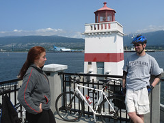
Stanley Park cycling 05/06/11
Keith cycling here and there:
“It was a great day for a ride. We moved quite quickly through the city, but had time to smell the roses. One rider went down early on on some railroad tracks, but is doing well! It was a great loop, tried my best to keep off totally busy streets as we meandered West, South, East then North. The food? I do not know how it works that you ask random people to bring food and it all goes together so well. (I once had a birthday where nobody talked and there were 7 cakes though…) Veggie lasagna, yam salad, and wild rice with salmon… and a cupcake!! It worked out very well. Here is the recipe for the salad:
Sweet Potato Salad With Orange-Maple Dressing
(Bon Appetit, June 2003)
The salad can remain at room temperature up to two hours before serving. Makes 12 servings.
Dressing.
1/4 cup extra-virgin olive oil
2 tablespoons pure maple syrup
2 tablespoons orange juice
2 tablespoons Sherry wine vinegar or balsamic vinegar
1 tablespoon fresh lemon juice
2 teas poons minced peeled fresh ginger
1/2 teaspoon ground cinnamon
1/4 teaspoon ground nutmeg
Salad:
6 pounds red-skinned sweet potatoes (yams), peeled, cut into 3/4-inch cubes
1 cup chopped green onions
1 cup chopped fresh parsley
1 cup pecans, toasted, coarsely chopped
1/2 cup golden raisins
1/2 cup brown raisins
For dressing:
Whisk all ingredients to blend in small bowl. Season dressing to taste with salt and pepper.
For salad:
Steam sweet potatoes in batches until potatoes are just tender, about 10 minutes per batch. Transfer sweet potatoes to large bowl. Cool to room temperature. Add green onions, parsley, pecans, and all raisins; Pour dressing over; toss gently to blend. Season salad to taste with salt and pepper. (Can be made 2 hours ahead. Let stand at room temperature.)”
Mayne Island cycling 04/06/11
Markus on Mayne Island:
“Seven of us headed out on a spectacular Saturday to check out the wonders of Mayne Island. In seven hours (coincidence?) we managed to cover most of the north of the island at a fairly relaxed pace, stopping at the Farmers Market, Georgina Point and Edith Point for a wander about/hike. We then headed inland to Mt. Parke and hiked up to Halliday Lookout where we had lunch while taking in the spectacular view of the Gulf Islands. I would recommend doing this as an overnight trip as there is still plenty more to see.”
Stanley Park cycling 29/05/11
Markus cycling the sea-wall in Stanley Park:
“Shout out to Rob M and Oksana for joining me in what has to have been the most laid back call-out I’ve ever been on. The weather was perfect for the myriad of stops that we made on the way. From investigating tidal pools around Stanley Park to finding little tucked away waterfalls around False Creek, we covered a lot more than just the distance from start to end.”
Baden-Powell Trail 22/05/11
Paul G. on the Baden-Powell Trail:
“Seven of us took in this hike along the base of Fromme and Grouse. The undergrowth is greening up nicely and the black flies have arrived. We were teased by the sun for a few minutes, but as we approached East MacKay Creek, the fog thickened, the forest darkened ominously and the skies opened up. Heavy rain and hail, but no frogs. Maybe next year 😉 (2012).”