Tag Archives: Tricouni Meadows

Tricouni Meadows East, 4 Jul 2015

Eugene Y. at Tricouni Meadows East:
“The Chance Creek FSR was in a pretty good condition and reasonably well marked with red bands at all the major intersections. With an OpenStreetMap, we had no difficulties navigating the road. My Protege easily made it to the 8.4 km mark (1050 m elevation). TJ drove his Outback for another 500 m. We walked the remaining 2 km of the road all the way to the trailhead.

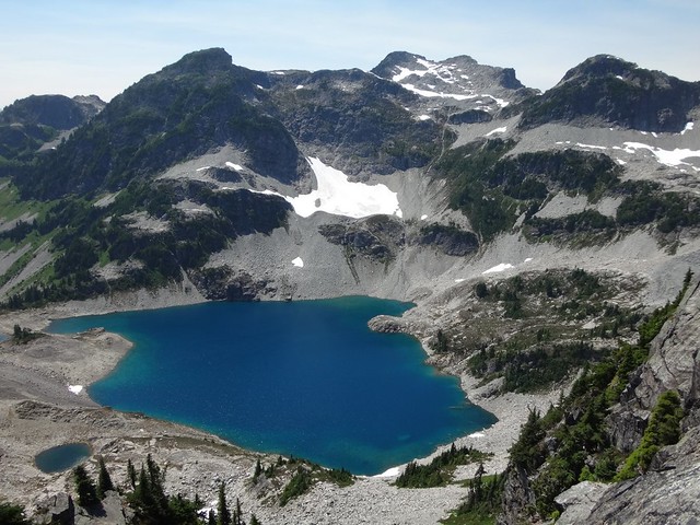
The trail was in a very good condition and mostly dry. After a 30 min walk through a pleasant forest we reached the blooming meadows about 800 m south of a large glacier-fed lake at the head of the High Falls Creek (1500 m elevation). At this point we split, as some of us went directly to the lake, while others ventured to explore the ridge on the east side of the lake.

Our route to the ridge involved some light bushwhacking, crossing a boulder field, and climbing a dry stream bed. Finally we reached a narrow plateau (1700 m elevation) that offered superb views of Tricouni, Garibaldi, and the surrounding areas. As we were running out of time, we decided against proceeding further along the ridge.

Once we descended to the lake, we joined the rest of the group for a pleasant swim. The lake itself proved to be a bit too cold, however, the large tarn on the east side was truly enjoyable.”

High Falls Lake (East Tricouni)

Tricouni Peak, 27 Jul 2014

Steve v. at Tricouni Peak:
“Did we make the peak? Almost. Did we see amazing scenery and views all around? You bet we did! This trip was one of those epic dayhikes that may have better been served as an overnight trip. The need for a good 4×4 makes this particular destination hard to reach for the average hiker but do what you can to someday come to Tricouni Meadows and Peak.

Lakes, waterfall, flowering meadows and open summits all awaited us, impressing us at every muddy step. Yes, that is right, the legendary muddiness of this trail was out in full force but really is only an issue for the first 1/4 from the trailhead. Another group of hikers told us there is a way less muddy trail on the other side of the creek and had the clean pants to show for it (someone look into this!).

The group (me, Tamara, Paul, Perry) held up a decent pace but we still found that the mud, combined with the extensive scree fields and snow patches put us way over the 7 hour time estimate listed in 103 Hikes. More like 9 hours with lunch but I can’t help but think maybe it is easier with more snow in certain parts than less.

After an exhausting hike out with an endless “last kilometre” we tried to get into the Watershed for some grub but it was packed and ended up at the Howe Sound Brew pub.

One last big thanks to Perry for getting us to the trailhead and for having a spare pair of boots to lend!”

Tricouni Peak, July 2014